
This hike starts in the southwest corner of Glacier National Park in the Apgar Mountains. From the bridge over McDonald Creek near the village of Apgar, travel along the Camas Road about 5.4 miles. You should see the sign for the Huckleberry Fire Lookout and a parking lot on your left not far after the McGee Meadow overlook.
The trailhead is at about 3,771 feet in elevation. The trail climbs 2,725 feet over 6 miles to reach the Huckleberry Lookout at 6,496 feet. It’s about the same distance as walking into Sperry Chalet and about 2 miles less than climbing to Granite Park Chalet from The Loop. However, I found the return downhill portion caused less pain in my knees than Sperry or Granite.
Since water is not available along the path nor at the lookout, be sure to pack enough for a 12-mile day. This is grizzly and black bear habitat. Make sure that you have bear spray where it will be quickly available and know how to use it. You probably don’t want to wait until you see the whites of a massive grizzly bear’s eyes to determine how quickly you can take the spray from its holster and remove the safety clip.
The day starts by walking through a mostly lodgepole pine forest. As you increase elevation, there will be more and more subalpine fir, and they will become further and further apart. As more sunlight is able to shine on the forest floor, there will be more and more huckleberry bushes.
The infamous 1910 fire burned a substantial part of the Apgar Mountains. This was followed in 1926 by the Huckleberry Fire which merged with the Half Moon Fire and consumed 95% of the Apgar Range. The Apgar Flats Fire of 1929 burned 19,000 acres including Huckleberry Mountain. In 1967, the Huckleberry Mountain Fire and Flathead River Fire burned a large part of the Apgar Mountains. It is believed that the 1910, 1926, and 1929 fires set the stage for the extensive growth of huckleberries in the area.4
Huckleberries are well adapted to fire. They primarily regenerate by root propagation rather than by seed after a burn.4 In fact, “hucks” need to burn at least every 10 to 20 years to produce well. If the forest canopy closes in around them, due to the absence of fire, it can result in fewer flowers and unripe fruit. In general, the bushes produce few berries if they go more than 60 years without burning.6 Of course, weather can complicate things. A late spring freeze or mid-summer frost can also affect production as can drought.

All of this great food has not gone unnoticed by grizzly and black bears. This is a hot spot for the bruins if the crop is good. In the Apgar Mountains where there are huckleberries, the highest probability of seeing bears is from the middle of July until late fall. Both the grizzlies and blacks feed on huckleberries in the lower to mid-elevations. But, as the timber becomes more sparse at a higher elevation, it’s mostly grizzly. Apparently, the density of the forest has an effect on the competition between the two.4
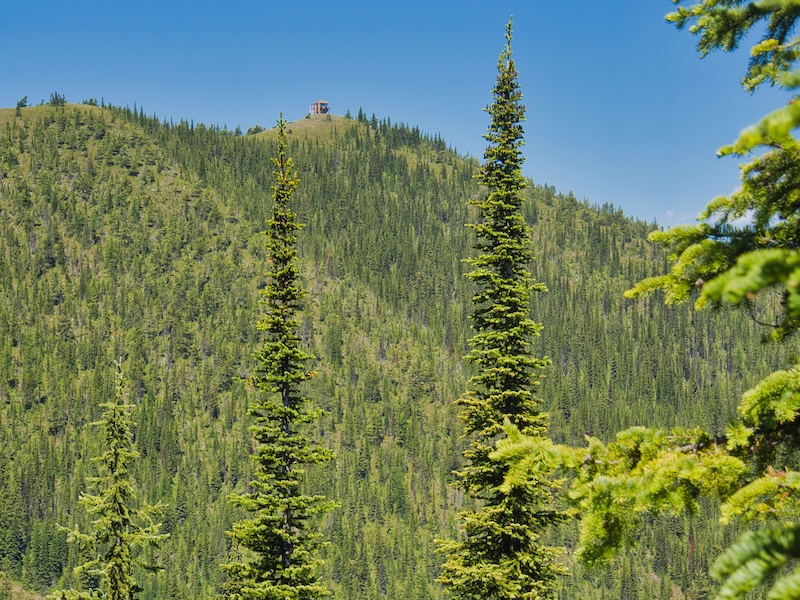
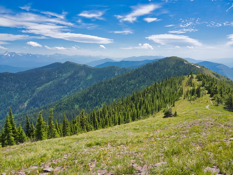
After 4 miles, the trail will go through a saddle, and the lookout tower can be seen. There is a steep drop-off as the path wraps around to the north side of the ridge. Even into the end of June, this section has the potential to be dangerous because of a lingering snowfield. It’s a good idea to check the Glacier National Park Trail Status Reports before heading out.
Also, in this section of the hike, you will see some beautiful red rock. Some of the boulders have ancient ripple marks that were formed over 1 billion years ago. Continental masses were separating during the second half of the Proterozoic Eon. This created an inland body of water that has been named the Belt Sea. The East African Rift Zone and the Red Sea is an example of something similar happening today.
The sediment that was eroded from the lifeless Earth surface was carried and deposited into the sea. The red rock results from deposits made in shallow water where there was enough oxygen to react with iron in the sediment. This formed iron oxide.5 It is the same chemical reaction that forms rust. There is evidence that indicates at least some of the deposit came from the west and southwest from land masses that eventually became Siberia and Australia.3,7

About 65 to 70 million years ago, toward the end of the reign of dinosaurs, an enormous section of the sedimentary rock that had formed under the Belt Sea was forced eastward 50 miles and uplifted over the younger formations of eastern Montana. The mountains of Glacier National Park are made of that rock.
Notice also that the Apgar Mountains do not have the knife-edged ridges as seen in other areas of the park. The more rounded form is the result of this range being wholly covered and then eroded by glacial ice during the Great Ice Age of the Pleistocene Epoch.4
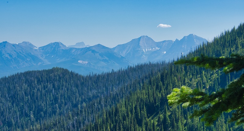
As you approach the summit of Huckleberry Mountain, views to the west of the Whitefish Range and to the east of the Livingston Range are spectacular. From the summit, one can see into Canada on a clear day.
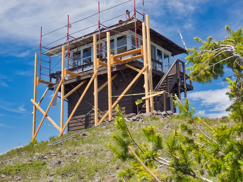
The Huckleberry Fire Lookout tower was built in 1933 and is on the National Register of Historic Places. Before this structure, there was a cabin topped with a cupola lookout. It was constructed in 1923.2

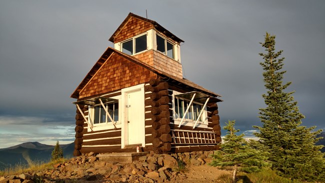
The only original example remaining of this type of building that I could find is the U.S. Forest Service Hornet Fire Lookout. It is also on the National Register.1 Hornet is about 24 air miles to the northwest of Huckleberry Mountain and perched on the summit of Hornet Mountain. This piece of history can be rented for overnight stays from mid-June to October for a nominal fee.
End Notes
- National Park Service, National Register of Historic Places. “Hornet Lookout.” Accessed November 1, 2018. https://npgallery.nps.gov/NRHP/AssetDetail?assetID=8fe0ab8a-3e69-47b6-a54b-96a37ff4e5f8.
- National Park Service, National Register of Historic Places. “Huckleberry Fire Lookout.” Accessed November 1, 2018. https://npgallery.nps.gov/NRHP/AssetDetail?assetID=22312362-033d-48b5-a72f-2427c0c81565.
- Sears, James W., Raymond A. Price, and Andrei K. Khudoley. “Linking the Mesoproterozoic Belt-Purcell and Udzha Basin Across the West Laurentia-Siberia Connection.” Precambrian Research. Accessed November 2, 2018. https://www.sciencedirect.com/science/article/pii/S0301926803002857.
- Shaffer, Stephen C. “Some Ecological Relationships of Grizzly Bears and Black Bears of the Apgar Mountains in Glacier National Park, Montana.” Scholarworks at University of Montana. Accessed November 1, 2018. https://scholarworks.umt.edu/cgi/viewcontent.cgi?article=4636&=&context=etd&=&sei-redir=1&referer=https%253A%252F%252Fscholar.google.com%252Fscholar%253Fhl%253Den%2526as_sdt%253D0%25252C27%2526q.
- Raup, Omer B., Robert L. Earhart, James W. Whipple, and Paul E. Carrara. Geology Along Going-to-the-Sun Road Glacier National Park, Montana. West Glacier, MT: Glacier Natural History Association, 1983.
- Rockwell, David. Exploring Glacier National Park. Guilford, CT: The Globe Pequot Press, 2002.
- Ross, Gerald M., and Mike Villeneuve. “Provenance of the Mesoproterozoic (1.45 Ga) Belt basin (western North America): another piece in the pre-Rodinia paleogeographic puzzle.” Geo Science World. Accessed November 2, 2018. https://pubs.geoscienceworld.org/gsa/gsabulletin/article-abstract/115/10/1191/1936/provenance-of-the-mesoproterozoic-1-45-ga-belt?redirectedFrom=fulltext.
