Howe Lake, ridge, and creek are the namesakes of Charlie Howe, the first homesteader (1892) at the foot of Lake McDonald and the first white man to locate Avalanche Lake and Sperry Glacier.3
Howe Lake is an easy and worthwhile destination spring through fall. And it’s likely you’ll not find the trail crowded. If you’re looking for more to fill your day, there are a couple of options at the end of this post.
As always, please apply Leave No Trace principles.
Trailhead
From the T-intersection near the Apgar Visitor Center, travel northwest on the Camas Road for 1.3 miles. The Fish Creek Campground Road will be on the right. Drive for 1.1 miles on that road until it Ys. Bear left.
The left fork puts you on the 100+-year-old Inside North Fork Road, which the Butte Oil Company carved through the timber in 1901. Although, at the time, calling it a road was probably a stretch. The unbridged, ungraded, and in places mucky route allowed the drillers to haul their machinery to the foot of Kintla Lake. Once the water froze, workers slid the equipment across the smooth surface to the drilling site.3,4
Drive 5.4 miles north on this historic and still somewhat primitive thoroughfare.
The Howe Lake Trailhead is on the right, and two small parking areas on the left. An interpretive sign, also on the left, describes the historic Matejka Homestead.
The Hike
About 13 percent of Glacier National Park burned during 2003, a record for the park. Lightning caused most of the fires that dry summer. Not so with the Robert Fire that burned this area. Careless humans started it. Snow finally put it out, but not until the flames had consumed 52,747 acres of timber.5

The trail leads you through young lodgepole pine stands, with widely spaced magnificent old larch trees that survived the inferno. Bright yellow glacier lilies and snow-white trillium put on excellent displays alongside the footpath in the spring. It’s impressive to see the healing taking place.
While you’re strolling along, be sure to make noise and have your bear spray where it’s quickly accessible. Know when and how to discharge it. We walked on top of grizzly bear tracks and dodged some scat during a May hike. On a separate trip, I encountered one of these powerful animals on the road just north of the Howe Lake Trailhead. Since the bruins use this area, it makes sense to be versed in bear safety.
At the Lake
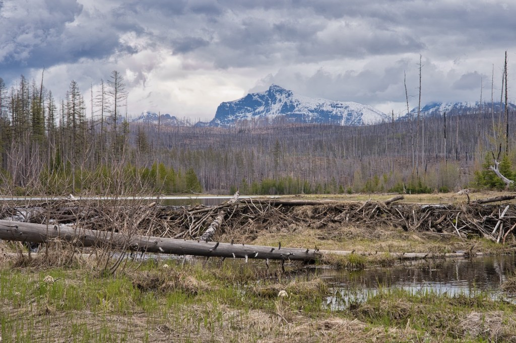
Before you know it, the first glimpse of water comes into view through the trees, and arrival at the outlet soon follows. Howe Ridge is visible to the east. The crest is about 1,000 feet above the lake’s surface and crowned with a glacial moraine. Imagine this spot under at least 1,000 feet of ice. If it was 20,000 years ago during the Pleistocene’s Great Ice Age, that would have been the case.1,2

The beaver dam across the outlet seems in pretty good shape. This is also true for the beaver lodge we spotted on the far side of the narrow channel connecting the lower and upper parts of the lake.
Howe Lake is an excellent place to see loons and other waterfowl. Be mindful that park service personnel prohibit fishing in the upper part of the lake until August to encourage loon nesting and protect their young until they attain fledging age. You’ll see the sign.

Hike Summary
| Total Distance: 3.2 miles |
| Total Elevation Gain: 240 feet; Loss: 108 feet |
| Difficulty*: 3.9, easy (Calculated using Petzoldt’s Energy Rated Mile equation.) |
| Total Walking Time: 1 hour 27 minutes (Calculated using an average speed of 2.5 mph and Naismith’s correction for elevation gain.) |
Options
If you choose to go farther, the trail continues east away from the lake and intersects the Howe Ridge trail in a little less than two miles. Or, once you return to your vehicle, drive another mile and a quarter north to the Camas Creek road closure. There, you’ll find the trailhead to Christensen Meadows and Rogers Meadow. I suggest this option. You can learn more about it here.
Notes
- Carrara, Paul E. ” Late Quaternary Glacial and Vegetative History of the Glacier National Park Region, Montana.” U.S. Geologic Survey. Last modified , 1989. https://pubs.usgs.gov/bul/1902/report.pdf.
- Raup, Omer B., Robert L. Earhart, James W. Whipple, and Paul E. Carrara. Geology Along Going-to-the-Sun Road Glacier National Park, Montana. West Glacier, MT: Glacier Natural History Association, 1983.
- Robinson, Donald H. Through the Years in Glacier National Park. Whitefish, MT: Glacier Natural History Association, Inc., 1973.
- Scott, Tristan. “The Road Less Traveled.” Flathead Beacon, May 11, 2017. https://flatheadbeacon.com/2017/05/11/road-less-traveled-2/.
- “The Fires of 2003: a synopsis.” The Trail Inside, Fall 2003. http://www.glacierparkfoundation.org/InsideTrail/IT_2004Win.pdf.
