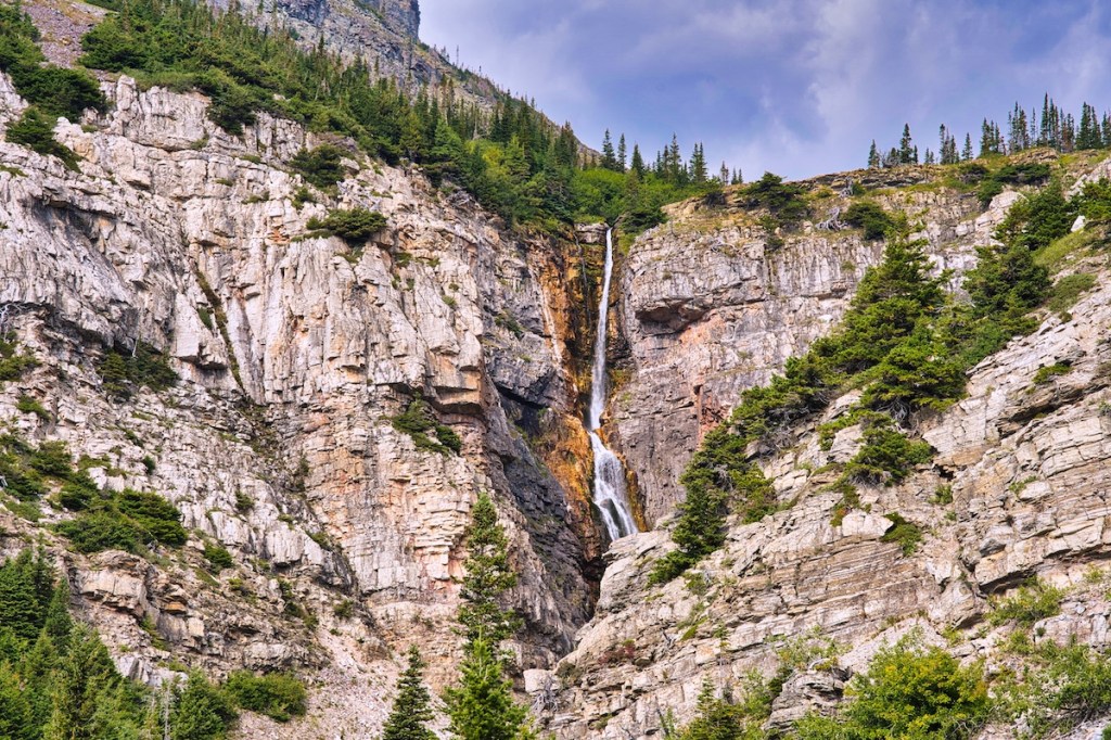
The liquid snow of Apikuni Creek presents a spectacular show when the Earth drops out from beneath it. The water plummets 160 feet over 1.5 billion-year-old Altyn limestone, the oldest rock on the park’s east side.1,2
Trailhead
Apikuni Falls Trail leaves the parking area to the northwest and the Red Gap Pass Trail northeast. The parking lot is 2.8 miles west of the Many Glacier Entrance Station. Or, find the trailhead 1.1 miles east of the Many Glacier Hotel road junction if driving from the west.
Wildlife
For whatever reason, bears seem to like this area. The last time we hiked to the falls, a black bear sow and three cubs crossed in front of us within the first quarter mile. Although we were at least 150 yards away, she gave us an unflinching stare until the little ones entered the brush. The same day, both morning and afternoon, we saw a grizzly bear near the parking lot – luckily from our car.

Several years ago, we exited the Red Gap Pass Trailhead after four glorious days in the backcountry. While walking back to the Swiftcurrent Inn and the truck, a grizzly bear sow and her cubs near the Apikuni and Red Gap parking lot caught us off-guard. Brush concealed her until she stood up with ears back and agitated. An alert Red Bus driver encouraged my hiking partner and me to pile into his empty bus. At the same time, he maneuvered his coach between the bear family and us.
I’ve seen several other bears on different occasions in the same general area. If you have spent little time in bear country, I recommend checking out the recommendations Glacier National Park’s Bear Safety webpage.
If you have binoculars with you, scan for bighorn sheep on the east slopes of Altyn Peak and near the falls.
The Hike
You’ll notice that I’ve rated the difficulty of the walk to the falls as easy. Compare this hike with 640 feet of elevation in a mile to the average increase of 490 feet per mile for Ptarmigan Tunnel or 430 feet per mile on the trek to Grinnell Glacier. Then why is it easy?
I use distance and elevation gain to calculate the difficulty score using Petzoldt’s Energy Rated Miles equation.3 If the trip were two miles uphill rather than one, it would rank as moderate difficulty. Climbing five miles with 640 feet of elevation gain per mile makes it strenuous. Apikuni Falls has an easy score, primarily because of low total distance (and energy expended).
During spring and early summer, the footpath starts out through a meadow loaded with color. Before you know it, you will enter the forest and start the climb. Along the way, a few side trails lead to spectacular views of the Swiftcurrent Valley and the peaks to the south.

The trail officially ends a short distance from the falls. Unofficial social trails proceed on to the base of the cascades. Beware of wet rocks and expect some light scrambling.
Hike Summary
| Total Distance: 2.0 miles |
| Elevation Gain: 640 feet |
| Difficulty: 3.3, easy* (Calculated using Petzoldt’s Energy Rated Mile equation.) |
| Total Walking Time: 1 hour 7 minutes (Calculated using an average speed of 2.5 mph and Naismith’s correction for elevation gain.) |
Notes
- “Apikuni Falls.” World Waterfall Database. Last modified December 11, 2018. https://www.worldwaterfalldatabase.com/waterfall/Apikuni-Falls-10170.
- Dyson, James L. “The Geologic Story of Glacier National Park.” Glacier Natural History Association. https://www.nps.gov/parkhistory/online_books/glac/3/index.htm.
- Petzoldt, Paul K. Petzoldt’s Teton Trails. Salt Lake City, UT: Wasatch Publishers, 1976.
