
This area is off the radar for most visitors during the summer. After the snow has blanketed the high country trails in the fall, this is a good option. If you’re ambitious, it is a definite consideration for a midwinter ski trip.
The Drive
From the West Entrance Station of Glacier National Park, drive to the ‘T’ intersection and then turn left onto the Camas Road. Travel about 1.2 miles and turn right onto to the Fish Creek Campground Road. After another mile, you should arrive at the junction for the Inside North Fork Road. Turn left and proceed along the narrow winding gravel road for 6.6 miles. Its blind curves can be dangerous. Be sure to stay on your side of the road.
In 1901, the Butte Oil Company carved a 40-mile path through the wilderness from Apgar to Kintla Lake. The rough, ungraded wagon road with stumps and bogs was made to haul oil drilling equipment to exploit the oil seeps found near the head of Kintla Lake. The well was drilled. It did not produce and was eventually abandoned.4 The original wagon path morphed into our Inside North Fork Road.2
Your clue that the drive is coming to an end is the bridge over Camas Creek. Shortly after crossing the stream, you should see the Camas Creek Trail sign on your right. The road is closed to automobiles a couple hundred feet beyond the trailhead.
Repeated flooding near Anaconda and Logging Creeks has rendered the road unsafe for cars and trucks. It’s an expensive fix. The park service has been evaluating their options. Despite that, hikers and bikers are welcome to use the road.
To Christensen Meadows
Straightaway, the path enters a lodgepole pine forest. But after only 0.3-miles, it breaks into extensive open areas. This is the beginning of Christensen Meadows.

Although the scenery does not match that of Rogers Meadow, the history is every bit as interesting. Ernest Christensen established his 160-acre homestead in 1896. He paid $16/acre which at the time was considered to be at the high end of its value.1
He and his neighbor Josiah “Joe” Rogers went away for a while to serve as packers in the Spanish-American War of 1898. When Christensen returned, he continued making improvements to his homestead. Some of these included the construction of a new log home, barns, root cellar, well, and fencing. He raised timothy hay and sold it to tourists and the Park Service. This hardworking settler also did horse packing with Joe Rogers and operated his own tourist business at Lake McDonald.1
Rogers Meadow
As you continue down the trail, you will notice that Camas Ridge, to the north, has burned in the past. The 70,609-acre lightning-caused Moose Fire of 2001 is to blame. To the south is Howe Ridge. The most recent burn, of course, was the Howe Ridge Fire. But, the man-caused Robert Fire of 2003 consumed 52,747 acres which included Howe Ridge. That promoted thick lodgepole pine growth and left an abundance of sizeable dead timber. The summer of 2003 has been referred to as the “Summer of Fire.” Fires that season burned 13% of Glacier National Park. It was the worst fire season in the park’s history.3
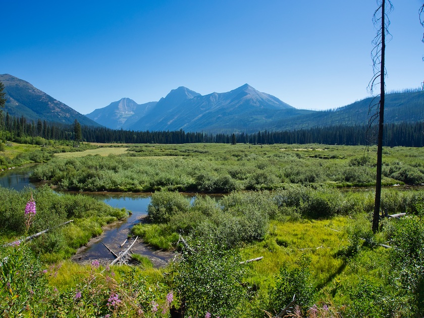
The trail continues in a northeast direction up the Camas Creek drainage and wanders in and out of forested areas. At 3.2 miles, the beautiful Rogers Meadow comes into view. Camas Creek slows here and meanders with full looping curves through the wetlands. The peaks of Stanton Mountain, Mount Vaught, Heavens Peak, and Rogers Peak are the striking backdrop to all this.
If you’re lucky, you might spot one of the beaver, river otters, or moose that call this place home. Bears and wolves are also known to move through this valley. This is the stuff of movies – the beaver slapping the water with his tail, the stream falling away from a moose’s antlers as he pulls his head from the water, the mournful howl of a wolf, and the silhouette of the humpback grizzly bear wandering across the meadow. It could happen.
Rogers started his homestead in 1896 too. When he and Christensen returned from the war, he began building his ranch. At one time, Josiah had 100 horses besides cattle. He raised 50 acres of timothy and constructed 1.5 miles of fencing. Oil exploration businesses and the U.S. Geological Survey crews used his packing services as did many visitors to the Lewis Glacier Hotel on the east side of Lake McDonald. Somewhere he found time to court the woman whom he married in 1902. He lost her to illness in the winter of 1908. Joe sold his ranch in 1914.1
Options
If you call it a day here and return the same way you came in, it will be a 6.4-mile round trip. The end of the Camas Trail is another 10.7 miles. The trail passes Trout Lake in 4 miles, Arrow Lake in 7.1 miles, and finds Camas Lake at the end. The path from Arrow to Camas requires several stream fords and can get pretty brushy. Probably best planned as an overnighter.
Another option is to continue up the Camas Creek Trail to the West Lakes Trail. That junction is a little south of Trout Lake. This route will lead you up and over Howe Ridge exiting at the north end of Lake McDonald. Christensen and Rogers most likely used the same path. The distance to the West Lakes Trailhead at Lake McDonald is about 7.5 miles from Rogers Meadow. Naturally, vehicle logistics will need to be worked out.
End Notes
- Bick, Patricia. Homesteading on the North Fork in Glacier National Park. West Glacier, MT: National Park Service, Glacier National Park, 1986.
- National Park Service, Glacier National Park. “North Fork Homesteads Resource Brief.” Accessed November 26, 2018. https://www.nps.gov/articles/north-fork-homesteads-brief.htm.
- National Park Service, Glacier National Park. “Fire History.” Accessed November 27, 2018. https://www.nps.gov/glac/learn/nature/fire-history.htm
- Robinson, Donald H. Through the Years: in Glacier National Park. 5th ed. West Glacier, MT: Glacier Natural History Association, Inc., 1973.
