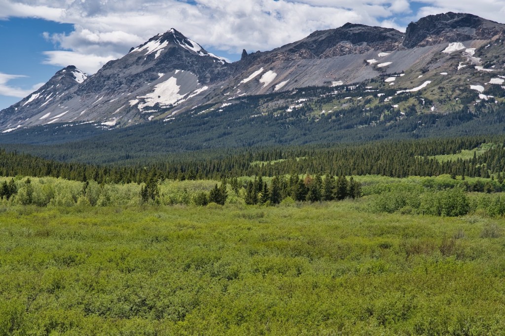
If solitude is what you’re after, this hike near the southeast border of Glacier National Park will deliver. Explore as little, or as much, as your group can handle. However, you’ll need two vehicles for the entire point-to-point trek. Remember, the park service prohibits dogs on all trails. And that’s a good thing in this grizzly bear habitat.
Trailhead
The trip begins atop the Continental Divide at Marias Pass and ends 8.6 miles later at a vehicle pullout on the north side of U.S. Highway 2 close to mile marker 203—the usual start for the Firebrand Pass hike.
At Marias Pass, on the north side of U.S. Highway 2, there is a large gravel area near the railroad tracks. Park there, cross the rails and walk along the tree line to find a trail headed north. This is the Summit spur trail, which provides access to the Autumn Creek Trail.

Hike
After one-half mile, the trail crosses an earthen dam on the west end of Three Bears Lake. In 1902, Great Northern Railway (GNR) built this structure and another one on the east end to raise the water level of the naturally occurring Summit Lake. GNR needed the increased volume to supply a 50,000-gallon storage tank at Marias Pass.1 There, steam locomotives replenished their onboard water supply.

When you intersect the Autumn Creek Trail, 1.1 miles from the trailhead, turn right. The easy-going path reaches its highest point of just under 6,000 feet in elevation 4.5 miles from the start and directly under the mountain formation known as The Mummy.
The footpath leads you through an open lodgepole pine forest with bear grass, huckleberries, and grouse whortleberries in much of the understory. When spring brings good rains, and there is ample soil moisture, bear grass blooms are spectacular. Small meadows along the path are home to a variety of other wildflowers. During June and July, they show off with multicolored displays.
Seven miles from the trailhead, look for the Lubec Trail junction (some refer to it as the Coonsa Trail). It’s another 1.5 miles to U.S. Highway 2. Panning east to west, Calf Robe Mountain, Summit Mountain, and Little Dog Mountain provide a spectacular scene.
Hike Summary
| Total Distance: 8.6 miles |
| Total Elevation Gain: 947 feet; Loss: 1,056 feet |
| Difficulty: 10.5, strenuous* (Calculated using Petzoldt’s Energy Rated Mile equation.) |
| Total Walking Time Estimate: 3 hours 52 minutes (Calculated using an average 2.5 mph speed and Naismith’s correction for elevation gain.) |
Autumn Creek Trail – Blacktail Hills Option
In winter, the Blacktail Hills route is popular with skiers and snowshoers. You’ll also need to plan for two vehicles on this point-to-point outing. The trip begins at Marias Pass, as described above, and ends near mile-marker 194 (193.8) on U.S. Highway 2. There is a pullout on the south side of the highway just east of the exit point. I recommend ending here so the steepest part of the trip is experienced going downhill.
Turn left (west) when reaching the Autumn Creek Trail. Little Dog Mountain will be north of the trail and Elk Mountain will appear to the west. During winter, the open areas on the east side of Elk Mountain down to Autumn Creek can be hazardous.
Orange tags on the trees mark the route. These are especially helpful after a snowstorm. If you’re traveling this trail in winter, be sure to check the Avalanche Report.
Hike Summary
| Total Distance: 5.7 miles |
| Total Elevation Gain: 579 feet; Loss: 1,126 feet |
| Difficulty: 6.9 moderate (Calculated using Petzoldt’s Energy Rated Mile equation.) |
| Total Walking Time Estimate: 2 hours, 34 minutes (Calculated using an average 2.5 mph speed and Naismith’s correction for elevation gain.) |
Notes
- “Three Bears Lake and Dams.” Library of Congress. Historic American Engineering Record National Park Service (HAER No. MT-88). https://cdn.loc.gov/master/pnp/habshaer/mt/mt0200/mt0273/data/mt0273data.pdf.
