On November 2, 1887, after three days of bushwhacking, George Bird Grinnell, Jack Monroe, and James Willard Schultz scaled the headwall of a magnificent glacial valley. The team was probably all smiles when they climbed up onto the glacier Grinnell had spotted through his spyglass two years earlier.2 Grinnell estimated the depth of the ice, which would later bear his name, at 600 feet.2
Grinnell became one of the prominent personalities who worked tirelessly to gain national park status for the extraordinary land he had explored.
Today millions of people travel to Glacier National Park. The Many Glacier Region, in the northeastern part of the park, is a hiker’s paradise. And one of the most popular destinations in this area is Grinnell Glacier. The trip to what remains of the once-mighty glacier often shows up in visitor’s top ten “must-do” lists. During July and August, don’t expect any solitude. But do expect to be awed by the scenery.

If you’d like to mix it up a bit, consider buying passage on the boats Chief Two Guns and Morning Eagle. Chief Two Guns is a 45-foot, 49 passenger launch that motors across Swiftcurrent Lake. Its dock at the foot of the lake is near the Many Glacier Hotel. Once at the head of the lake, there is a short walk to the pier on Lake Josephine. There the 49 passenger Morning Eagle is waiting to take folks to the head of her lake. Using the boats will knock off a little over three miles of the walk to the glacier. Check out Glacier Park Boat Company’s website for current fees and time schedules.
Planning
It’s not uncommon for the park service to post a warning or close the Grinnell Glacier Trail because of grizzly bears. If you’re unfamiliar with traveling through bear habitat, I recommend Glacier National Park’s Bear Safety web page. There’s a lot of valuable information, including a video presentation by a park bear biologist.
Also, check the Glacier National Park Trail Status page. The following is an example from July 10, 2021.
Grinnell Glacier Trail
CLOSED for bear frequenting from Thunderbird Falls to the end of the trail 7/10/21 per 822
Projected initial clearing date: 7/23/21 per 650
High-angle snow hazards exist approximately 1.5 miles above the junction with Josephine Lake (3.5 miles from the trailhead at the picnic area). Crampons, ice axe, and extensive experience with ice travel would be recommended.
And while you’re at it, visit Glacier National Park’s Trail and Area Closings and Postings web page.
I also encourage you to check the National Weather Service Recreation Safety Forecast web page to reduce the chances of nasty weather surprises.
If you’ve not done many longer hikes in the backcountry, consider REI’s Day Hiking Checklist. It’s a good one.
Trailhead
Hiking the entire Grinnell Glacier Trail is the focus of this post. The strenuous hike begins in the Many Glacier picnic area about 0.5-miles past the road to the Many Glacier Hotel. The trailhead is well marked at the south end of the parking lot, which fills early during July and August. Additional parking is sometimes available just before the picnic area beside the road.
The Many Glacier Hotel is an alternate starting point. You will meander along the eastern and southern shores of Swiftcurrent Lake before intersecting the Grinnell Glacier Trail. This route is about three-tenths of a mile longer than that starting at the picnic area.
Hike
Hike Summary
| Total Distance: 10.6 miles |
| Total Elevation Gain: 2,277 feet; Loss: 701 feet |
| Difficulty: 15.2, strenuous* (calculated using Petzoldt’s Energy Rated Miles) |
| Estimated Walking Time: 5 hours 22 minutes (calculated using an average 2.5 mph walking speed and Naismuth’s Rule to compensate for elevation gain) |
The first two miles of the footpath are relatively level and forested. You’ll walk along the western shores of Swiftcurrent Lake and Lake Josephine. Grinnell Point, the prominence seen from the Many Glacier Hotel, rises to the north.
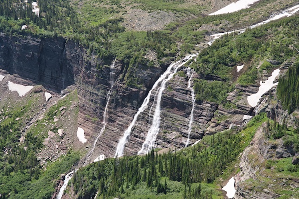
After the Josephine Trail junction, the climb begins in earnest. The icy-cold Grinnell Falls, crashing 960 feet down the headwall, appears about one mile past the Josephine intersection.1 With elevation gain, trees become fewer and stunted. A great birds-eye perspective of the u-shaped glacial valley with its shimmering lakes then opens up. To appreciate the immensity of this landscape, one needs to experience it. Photographs fall short.
About 3.5 miles from the trailhead, Thunderbird Falls spills onto the cliff-hugging trail. Then, a short distance up the path, one may encounter a steep snowfield burying the footpath. This frozen mass can persist into July and might be dangerous to cross. Checking with park rangers about potential hazards before embarking would be a good call.
One is likely to walk over fossilized ripple marks exposed during trail construction. Water agitation in the shallow sea environment of the ancient Belt Sea formed these sediment ridges over one billion years ago. During hundreds of millions of years, thousands of feet of sediment stacked one layer upon another in the sea basin. Heat and pressure cemented the loose particles into solid rock. Finally, tectonic forces shoved the massive rock mass eastward 50 miles and uplifted it as it slid over the top of much younger rock. The foundation of Glacier National Park started as the mucky bed of the Belt Sea.
As the climb continues, the route becomes a narrow shelf blasted into the side of a cliff. Far below at the bottom of the steep drop-off is Grinnell Lake, a turquoise gem. Rising abruptly from its far shore is the sheer rock face of Angel Wing, backed by the massive Mount Gould. A near-vertical rock wall is the view on the opposite side of the trail.

When the path leaves its perch on the rock face, it crosses open areas where you might see bighorn sheep and mountain goats. A picnic area with a pit toilet offers a great place to rest before the final 400-foot and 0.4-mile climb over the glacial moraine to Grinnell Glacier and Upper Grinnell Lake.
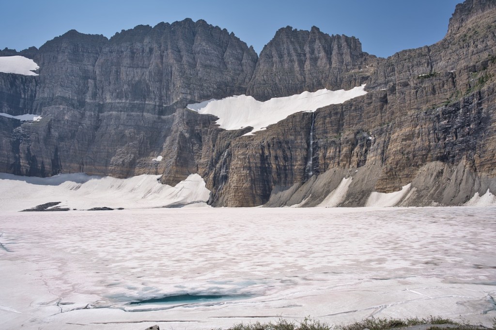
Grinnell Glacier
The ice-scoured rock beside Upper Grinnell Lake is a popular place to hang out, surrounded by fantastic scenery. Directly across the water, Salamander Falls plummets 440 feet with meltwater from Salamander Glacier.4
Salamander, once part of the vast Grinnell Glacier, shrunk 23 percent between 1966 and 2015.3
The remnants of Grinnell Glacier lie at the south end of the cirque beneath the massive Mount Gould. During the same period mentioned above, Grinnell lost 45 percent of its area.3
The USGS Repeat Photography Project documents changes in glaciers by placing historical photographs alongside more recent photographs taken from the same location. The pictures of Grinnell Glacier say it all.
In the past, rangers took visitors out onto Grinnell Glacier. This no longer happens. The risks of crossing the outlet of Upper Grinnell Lake and walking on top of weakened ice with hidden crevasses are too great.
Since 1900, the mean annual temperature for Glacier National Park and the surrounding region has increased by 1.3 ℃, which is 1.8 times the global mean increase.3
Gem Glacier succumbed to rises in temperature and lost its classification as a glacier because it no longer met the 25-acre criteria.3 The last bit of the former glacier hugs the Garden Wall south of Salamander and west of Mount Gould.
Glacier National Park Guidebooks
Your Ultimate Guide to Going-to-the-Sun Road: Invest in your adventure and unlock the full potential of this iconic road. For the price of a movie, a lifetime of memories.
Invest in Your Next Adventure: For a small price, you can unlock countless hours of outdoor enjoyment. Start exploring!
Notes
- “Grinnell Falls, Glacier County, Montana, United States.” World Waterfall Database. Last modified March 19, 2017. https://www.worldwaterfalldatabase.com/waterfall/Grinnell-Falls-482.
- Minetor, Randi. Historic Glacier National Park: the stories behind one of America’s Great Treasures. Guilford, CT: Rowman & Littlefield, 2016.
- “Retreat of Glaciers in Glacier National Park.” United States Geological Survey. Last modified, 2013. http://npshistory.com/publications/glac/glacier-retreat-2013.pdf.
- Salamander Falls, Glacier County, Montana, United States.” World Waterfall Database. Last modified March 19, 2017. https://www.worldwaterfalldatabase.com/waterfall/Salamander-Falls-759.
