
Suppose you don’t feel like climbing to the pass. In that case, there are three wonderful subalpine lakes plus waterfalls to see along the route. They involve shorter distances and not much elevation gain. You’ll find more information in this post.
If you want more than the pass, Swiftcurrent Lookout Trail heads north near the pass and climbs 1,248 feet over 1.4 miles. The views from up there are outstanding.
Another option is to begin at Logan Pass and walk the Highline Trail past Granite Park Chalet until the path intersects the Swiftcurrent Pass Trail. Follow that back to Many Glacier. This route is a little over 15 miles with 2,844 feet total elevation gain and 4,553 feet loss. Transportation logistics are a must with this trip. Consider leaving your vehicle at the Logan Pass parking lot. At Many Glacier, catch a fee-based hiker’s shuttle to Saint Mary. From Saint Mary, use the free Glacier National Park Shuttles to return to Logan Pass.
The rest of this post is devoted to the out and back hike from Many Glacier to Swiftcurrent Pass.
The Trailhead
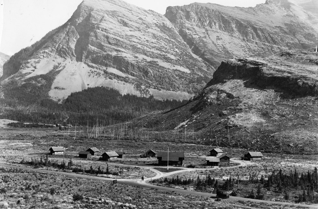
Once on the Many Glacier Road, drive to the parking lot in front of the Swiftcurrent Motor Inn (originally Swiftcurrent Auto Camp). This spot is five miles west of the Many Glacier entrance station. The well-marked Swiftcurrent Pass Trail begins just west of the inn.
The main building and cabins mark the “turning of a page” in Glacier National Park history. In the park’s early days, the Great Northern Railway (GNR) lured wealthy folks away from their vacations in the Swiss Alps and to the “alps” of America in Glacier National Park. These tourists expected top-shelf service, and they got it for a price.
Around the early 1930s, a different type of visitor emerged. The automobile made it possible for tourists to be mobile and independent of Great Northern. They demanded less extravagant lodging and service than that offered by the Many Glacier Hotel. Their voices were heard.
In 1933, Swiftcurrent Auto Camp began with the building of cabins described as “spartan and inexpensive.” Construction continued in 1935 with a general store at the east end of the current main building. In the 1940s, builders added the lobby space and restaurant at the west end.12 If you get a chance, it’s worth a look inside these historical buildings.
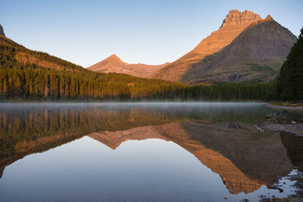
Long before the auto camp, horses and their riders rode down the Swiftcurrent Valley, making their way to the Many Glacier Hotel. This was the last leg of a multi-day backcountry camping trip known as the North Circle.3 As you walk along the Swiftcurrent Pass Trail, know that you are enjoying the same magnificent scenery that many have for over a century.
Fishercap Lake (0.7 miles)
A quarter-mile after leaving the trailhead, a path veers left toward the shore of the lake with the peculiar name. The Blackfeet gave their friend George B. Grinnell the moniker Fishercap, which was then attached to the lake.9
The soft glow of early morning light on the water, Swiftcurrent Mountain, Mount Wilbur, and Bullhead Point creates an excellent scene for photographs. Not only that, but the valley from Fishercap Lake to Bullhead Lake has superb moose habitat. And, although there are no guarantees, the best time to see these impressive animals is early morning and evening.
Redrock Lake (1.3 miles) & Redrock Falls
The Swiftcurrent Pass Trail continues from the Fishercap Lake Trail junction through mixed lodgepole pine and fir forest. Intermixed stands of quaking aspen show off glowing yellow leaves in October. One and a half miles from the trailhead, there is a short side path to a gravel beach on the north side of Redrock Lake. It’s worth a look.
Continue toward the west end of the lake and find a spur trail at 1.8 miles leading to the lower part of Redrock Falls. The best show is early in the season. After you return to the primary route, climb a little, and then pass next to Swiftcurrent Creek and the upper section of the falls.

The conspicuous red to maroon rock from which the lake and falls take their name is part of the 2,500-feet-thick Grinnell Formation. Over a billion years ago, a Siberia size landmass began separating from what would become North America. A shallow inland sea formed in the resulting basin. Here, streams and rivers dumped the silt and sand they carried from the surrounding lifeless land. Over time, heat, pressure, and oxygen content produced multi-colored layers of rock. Then, tectonic forces pushed those layers, which were miles deep, eastward 50 miles, and upward.1
When the park’s rocks were forming, life in the ancient sea consisted of single-celled cyanobacteria. Since 3.5 billion years ago, these primitive organisms have produced oxygen and contributed substantially to an atmosphere that supports life as we know it.11 Stromatolites, fossils of the structures these organisms made, exist not only in the Grinnell Formation but within many others throughout the park.4
During the Pleistocene Epoch, glaciers thousands of feet deep filled the valleys of what is now Glacier National Park. Peaks of the mountains would have appeared like islands in the seas of ice. When the glaciers receded around 12,000 years ago, they left amazing hanging and u-shaped valleys, aretes, horns, and cirques that characterize the park.
Bullhead Lake (3.9 miles to the west end)
You’ll cross a suspension bridge over a stream flowing from Windmaker Lake about three and a half miles from the trailhead. Watch for a path headed toward Bullhead Lake about 500 feet after the bridge. I think the views are better there than those at the west end of the lake.

A couple hundred feet farther west from the junction mentioned above, some not so apparent trails lead down to the shore. I used one of those when I needed to replenish my water supply coming back from the pass. Be sure to use some sort of water purification system.
Swiftcurrent Headwall
After leaving the west end of Bullhead Lake, cross Swiftcurrent Creek and head south into the drainage nestled at the base of Mount Grinnell, the Garden Wall, and a flank of Swiftcurrent Mountain. The trail crosses a pretty braided stream channel, but there is a plank bridge. It’s put in place in June and taken out in September. Check Glacier National Park’s Trail Status Reports.
In 1910, an official from the Department of the Interior visited the newly established Glacier National Park. He hired Josiah Rogers, an owner of stock and packer on the west side, to take him through the park, including a trip over Swiftcurrent Pass at the end of the journey. Rogers balked at this last request. He finally agreed when a contract guaranteed $100 for each horse lost while traveling over the dangerous route.9
The ride over a primitive trail scratched into cliffs must have made an impression on Roger’s guest. In those days, there wasn’t much money available for the park. But somehow, the government found funds to reconstruct the Swiftcurrent Pass Trail.9
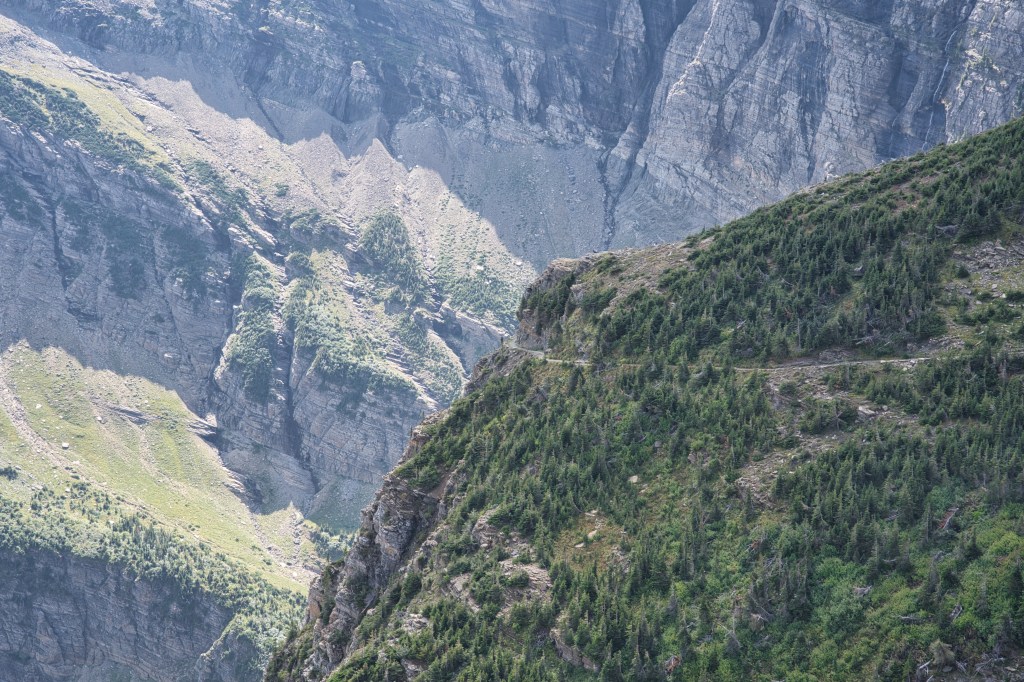
One must climb over three miles using several switchbacks cut into the headwall to reach the pass. Otherwise known as “Galen’s Ladder,” workers constructed these hairpin-turns for the footpath during the 1913 trail reconstruction.9

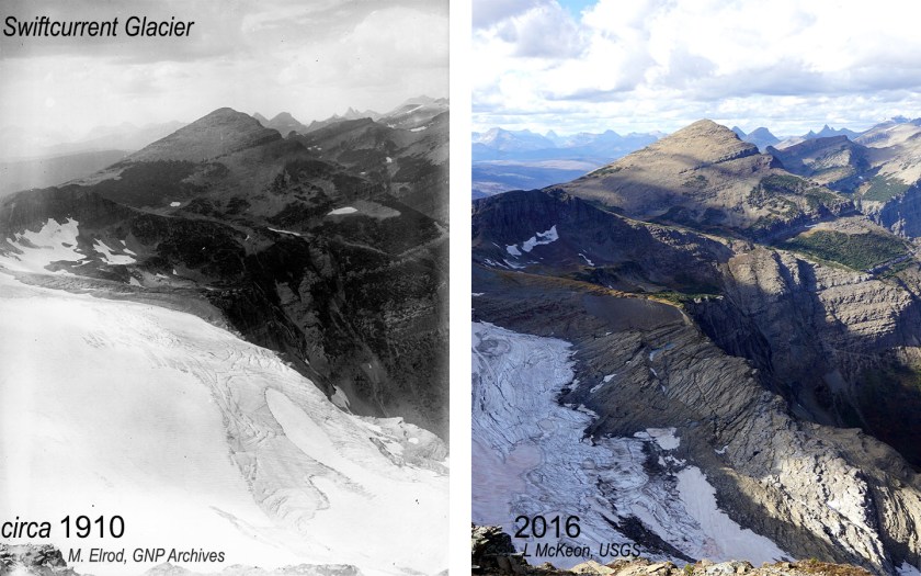
Grand waterfalls plummeting down the eastern rock face of the Garden Wall add to the spectacular scenery as you gain elevation. Swiftcurrent Glacier clings to an east face of the Garden Wall not far below the ridge top. Several viewing points will present themselves as you make your way up the trail. This glacier has decreased about 71% since the mid-1800s.10 Modern glaciers, like Swiftcurrent, are not holdovers from the Pleistocene, which ended about 12,000 years ago. The 26 remaining glaciers in the park have only been around for 7,000 years.8
“A rolling wall of flame.”9 Park superintendent Scoyen said, “I have never seen as complete a burn-out as occurred in Swiftcurrent Valley. With the exception of a few swampy areas, every green living thing from rocks on one side of the valley to the other, has been destroyed.”5 Those words described the 8,364-acre, 1936 Heaven’s Peak Fire and its aftermath.
It all began on August 18, with a lightning strike above the Glacier Wall west of the continental divide. On August 31, violent winds carried firebrands east over Swiftcurrent Pass. They ignited the forest as much as 1.5 miles ahead of the main fire. The Many Glacier Hotel was spared, but the wildfire consumed many other buildings.5

Looking down on the green Swiftcurrent Valley from several viewing points along the headwall, one would never suspect that such an inferno was part of Many Glacier’s history.
Devil’s Elbow is the last major switchback on the trail. Envision sitting on a horse or leading the critters around that hairpin turn with a vertical drop of hundreds of feet within a few steps of the path.
Swiftcurrent Pass
A small pile of rock rubble on the left side of the footpath marks the pass at 7,185 feet. It is all that remains of the base constructed in 1926 to support a locomotive bell. GNR installed bells at Swiftcurrent, Piegan, Siyeh Passes, and a fourth near Scenic Point. Great Northern borrowed the unique Swiss custom of placing bells on mountain tops and passes so that hikers could produce a loud clang upon arrival. It was in line with the railway’s advertising slogan “Alps of America” to promote Glacier National Park.9

Hike Summary
| Total Distance: 13.7 miles |
| Total Elevation Gain: 2,611 feet; Loss: 370 feet |
| Difficulty: 18.9, strenuous* (Calculated using Petzoldt’s Energy Rated Mile equation.) |
| Total Walking Time Estimate: 6 hours 47 minutes (Calculated using an average speed of 2.5 mph and Naismith’s correction for elevation gain.) |
Glacier National Park Guidebooks
Your Ultimate Guide to Going-to-the-Sun Road: Invest in your adventure and unlock the full potential of opportunities along this iconic road. For less than the price of a movie, a lifetime of memories.
Don’t guess, know. Tom Berquist, a local with nearly 1,000 miles hiked in Glacier, provides the reliable information you need to explore the east side of the park in this comprehensive and trustworthy hiker’s companion.
Notes
- Bentley, Callan. “The Belt Supergroup in Glacier National Park.” American Geophysical Union. Accessed February 18, 2019. https://blogs.agu.org/mountainbeltway/2013/08/27/guest-post-the-belt-supergroup-in-glacier-national-park/.
- “Glacier Fire Map 1910-2015.” Glacier National Park Fire History. https://www.nps.gov/glac/learn/nature/fire-history.htm.
- “Glacier National Park Tourist Trails: Inside Trail; South Circle; North Circle.” National Archives Catalog. https://catalog.archives.gov/id/71974954
- Hunt-Foster, Rebecca K. “The Stromatolites of Glacier National Park.” National Park Service Park Paleontology News – Vol. 10, No. 2, Fall 2018. Last modified , 2018. https://www.nps.gov/articles/park-paleo-fall-2018-stromatolites.htm.
- Larson, Rolf L. “Firestorm!.” Glacier Park Foundation. Last modified , 2012. http://www.glacierparkfoundation.org/History/firestorm.html.
- “Moose.” Wikipedia. Last modified January 13, 2021. https://en.wikipedia.org/wiki/Moose.
- “Moose – Alces americanus.” Montana Field Guide. Montana Natural Heritage Program and Montana Fish, Wildlife and Parks.. http://fieldguide.mt.gov/speciesDetail.aspx?elcode=AMALC03010.
- “Overview of Glacier National Park’s Glaciers.” National Park Service: Glacier National Park. Last modified August 17, 2021. https://www.nps.gov/glac/learn/nature/glaciersoverview.htm.
- Robinson, Donald H. Through the Years in Glacier National Park. West Glacier, MT: Glacier Natural History Association, Inc., 1973.
- “Status of Glaciers in Glacier National Park.” United States Geological Survey Northern Rocky Mountain Science Center. https://www.usgs.gov/centers/norock/science/retreat-glaciers-glacier-national-park?qt-science_center_objects=1#qt-science_center_objects.
- “Stromatolites.” Indiana University. https://geol105b.sitehost.iu.edu/images/gaia_chapter_10/stromatolites.htm
- “Swiftcurrent Auto Camp Historic District.” National Register of Historic Places Digital Archive on NPGallery. Last modified January 1, 1996. https://npgallery.nps.gov/NRHP/AssetDetail?assetID=9e575759-c2a0-4079-8d43-99638b12c14a.
- “Swiftcurrent Glacier. Glacier National Park, Montana. Repeat photography 1910 – 2016.” United States Geological Survey Denver Library Photographic Collection. https://www.sciencebase.gov/catalog/item/5efcf7f882ce3fd7e8a5bb10.
- ”USGS Denver Library Photographic Collection: Glaciers of Glacier National Park Repeat Photography.” USGS: science for a changing world. https://usgs.libguides.com/usgsphotolib/glaciernp.
