I feel like I am favoring one child over another when I say that Two Medicine is my favorite area in Glacier National Park. I love the entire park. But, the Two Medicine Valley calls to me.
This special place is located on the east side of the Continental Divide and the Lewis and Clark Range in the southeastern corner of Glacier National Park. It’s a 20-minute drive from East Glacier.
A Little Background
This area was and still is a sacred place to the Blackfeet Indians. The name Two Medicine comes from the Blackfeet name Na-too-too-kase which means Place of Two Medicine Lodges.12 Running Eagle Falls is named for a famous female Blackfeet warrior. Born Otaki, the male name Pitamakan or Running Eagle was bestowed on her by Chief Lone Walker for her bravery in battle. Her fate was sealed after she returned from her vision quest in the cave of rushing water – Running Eagle Falls. There she prayed and fasted for most of a week for direction in her life. The upshot was that she would never marry and would live in service of her people.9,11
The Two Medicine Road passes the trailhead for Running Eagle Falls. The 0.3-mile long trail is paved and handicap accessible. In addition to the spiritual connection to the Blackfeet, this feature has geological significance.
The sedimentary rock which makes up the mountains of Glacier National Park was formed from sediment deposited in the basin of the ancient Belt Sea from 1.6 billion years ago to about 800 million years ago. Starting about 750 million years ago, unimaginable tectonic forces shoved all of that rock 50 miles to the east resulting in the Lewis Overthrust Fault. The eastern terminus, the fault, is just below the limestone rock of Running Eagle Falls.1
Two Medicine was one of the most visited areas of the park when the Great Northern Railway was the primary mode of transportation that brought passengers to stay at the chalets they had built. After the completion of the Going-to-the-Sun Road in 1932, that changed. Even today, Many Glacier and Saint Mary visitors far outnumber those going to Two Medicine.7 I’m not saying that’s a bad thing.
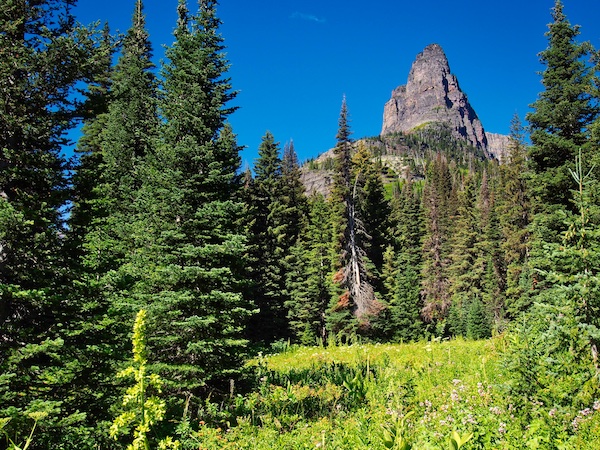
On the Two Medicine Road, you will come to a particular place where a mountain fills most of the skyline. That is Rising Wolf Mountain (9,513 feet). A fitting name for a peak that greets visitors as they embark on their exploration of this region. I first assumed the name was derived from Canis lupus – the gray wolf that inhabits parts of Glacier National Park. Not so. Rising Wolf was the name the Blackfeet gave to the Hudson’s Bay trapper and explorer Hugh Monroe.8

Monroe joined the Hudson’s Bay Company in 1815 at the age of 16.8 In the early 1820’s, he was sent to live with the Blackfeet to ensure that they delivered their furs to Hudson’s Bay trading posts, scout for beaver, and ascertain what the competition from America was doing.10 He eventually went to live with Lone Walker’s band of the Blackfeet and married his daughter Sinopah. He is thought to have been the first white man to explore the region that would become Glacier National Park. Hugh Monroe became a legend in his own time and was written into history in the 1919 book Rising Wolf by James Willard Schultz.8
Once you reach the developed area at Two Medicine Lake, there is a decision that needs to be made. You can leave your car in the parking lot adjacent to the Two Medicine Camp Store and the boat dock. There is a small booth near the lake where tickets may be purchased. However, I would recommend buying tickets online at least 24 hours ahead of your arrival to ensure that there will be a seat for everyone in your group.
The other option is to park your car near the trailhead at Pray Lake, where you exit at the end of the day. From there you will need to walk a little over one mile to reach the boat dock where you embark on the Sinopah.
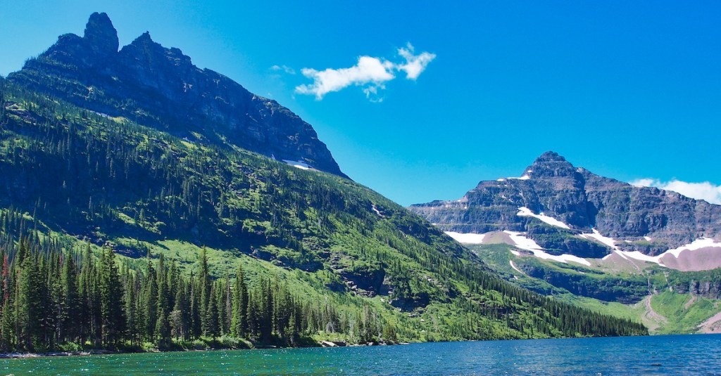
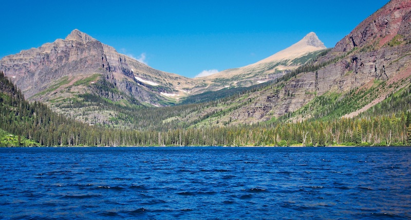
Take a moment or two to savor the spectacular mountain scenery. At the head of the lake, the beautiful Sinopah Mountain rises abruptly 3,100 feet above the water. The summit of Rising Wolf Mountain, to the north, looks down from 4,350 feet above your location.
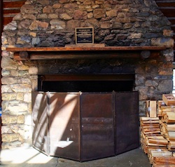
Step back in time and visit the Two Medicine Camp Store, a National Historic Landmark. This building was originally the Two Medicine Chalets kitchen and dining hall built by the Great Northern Railway in 1912. President Herbert Hoover used the Two Medicine Chalets complex as his base of operations in August 1930. On August 5, 1934, President Franklin Delano Roosevelt gave one of his famous Fireside Chats by the fireplace in the dining hall building.6
Trailhead
There are several options for getting to and returning from Upper Two Medicine Lake. If you choose to hike the North Shore Trail, it is 4.4 miles one way. The trailhead for this route begins by the campground parking lot near Pray Lake. If you take the South Shore Trail, it is about 5.5 miles one way. You will find the trailhead near the Two Medicine Camp Store and boat dock. Finally, there is the option of motoring to the west end of Two Medicine Lake aboard the Sinopah, hike 1.9 miles to Upper Two Medicine Lake, and then return 4.4 miles via the North Shore Trail for a total of 6.3 miles or 6.5 miles if you include Twin Falls. The remainder of this post will describe the third alternative.
Travel to the west end of Two Medicine Lake aboard the historic 45 foot, 49 passenger Sinopah. Constructed in 1926 by J.W. Swanson, Sinopah is the oldest wooden boat in the Glacier Park Boat Company’s fleet. She was bought by the company in the 1940s and moved from Saint Mary Lake to Two Medicine Lake. The name was then changed from Little Chief to Sinopah.2
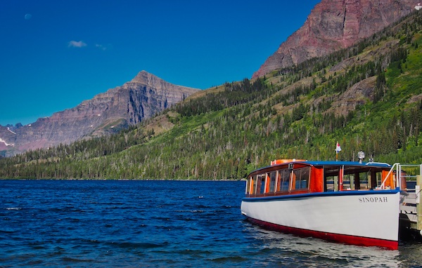
To the north is the massive Rising Wolf Mountain, to the south Painted Tepee Peak (7,650 feet) and to the southwest is the majestic Sinopah Mountain. Toward the latter part of the trip, watch to the northwest to catch a glimpse of the light colored, pyramid-shaped glacial horn Flinsch Peak (9,225 feet). Enjoy the 30 to 45 minute trip and commentary by the boat captain.
The Hike
After you disembark, you will cross a boardwalk over a boggy area. As you walk through the spruce and subalpine fir forest, watch for dark vertical lines on the trees. The lines will be from a few feet long to almost the height of the tree. These are frost cracks. They are a testament to the bitter cold and extreme temperature fluctuations that can happen in this area of the park. When they occur, it can sound like a gunshot.
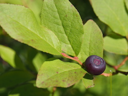
This moist area produces large patches of thimbleberries. If you’re lucky, they’ll be ripe.
Watch for the park trail signs. The first junction gives you the choice of the South Shore Trail to the southeast or a path heading in a northwest direction. You will want to go to the northwest.
At about 0.7 miles from the boat dock and after a footbridge over Two Medicine Creek, you will reach another trail junction. Go left or westerly toward Twin Falls and Upper Two Medicine Lake. A right or easterly direction will put you on the North Shore Trail to the Two Medicine Campground. From the junction, it is about 1.2 miles to Upper Two Medicine Lake.
To your right, a large elongated cone-shaped mass of rock will eventually show itself. This is Pumpelly Pillar (7,620 feet). Glaciers carved both sides of this mountain into a narrow ridge (arete) as they flowed eastward toward the plains. The spire was known by the Kootenai Indians as Standing Arrow.12 It was renamed for Raphael Pumpelly who was the leader of the Northern Transcontinental Railway survey party. Traveling with Pumpelly was Major Logan, who became the first superintendent of Glacier National Park in 1910 and is also the person for whom Logan Pass was named. They crossed Pitamakin Pass in 1883.8
The spur trail to Twin Falls can be found approximately 300 feet after you cross a small creek on your way to Upper Two Medicine Lake. It is a worthwhile and easy 0.2-mile round trip.
Just before arriving at Upper Two Medicine Lake, the trail passes near a small body of water that will be on your left. Don’t be fooled. This is not your destination. Upper Two Medicine Lake is well over 100 acres.
When you do arrive at Upper Two Medicine Lake, the trail will lead you to the backcountry campground. The campground has four sites. Two of these can be reserved. There is a limited beach nearby.
This is an excellent spot to enjoy a bite to eat and take in the views. The end of the lake is dominated by Lone Walker Mountain (8,502 feet). Mount Rockwell (9,272 feet) is to the south, Mount Helen (8,538 feet) to the northwest, and Pumpelly Pillar to the north. Mount Helen, Lone Walker Mountain, and Mount Rockwell mark the Continental Divide.
You may have noticed that there is a lot of red rock in the surrounding mountains. This sedimentary rock is of the Grinnell Formation which can be up to 2,600 feet thick. The red color comes from the reaction of oxygen with iron. This happened to the sediment deposited in the shallow water of the ancient Belt Sea during the Precambrian Time – over one billion years ago.5 Preserved mud cracks and ripple marks can also be found in this formation.
To return the 4.4 miles via the North Shore Trail, hike back down the trail that you arrived on. Walk past the junction for the path that leads to the boat dock. About 1.6 miles from Upper Two Medicine Lake, you will come to a new trail junction. The park trail sign will indicate that the route to the left will go to No Name Lake and Dawson Pass. If you take that way by mistake, it will not take very long to realize the error. There is some pretty serious elevation gain.
The final 3.1 miles of the footpath has minimal elevation gain and loss. Huckleberries are an added bonus around the middle of July. Before you know it, the trail comes to a bridge over Two Medicine Creek and then toward the Two Medicine Campground. If you had parked by the Two Medicine Camp Store, there is roughly one more mile to walk to reach your vehicle.
Glacier National Park Guidebooks
Your Ultimate Guide to Going-to-the-Sun Road: Invest in your adventure and unlock the full potential of a trip on this iconic road. For the price of a movie, a lifetime of memories.
From Novice to Expert, We’ve Got You Covered: For the price of a huckleberry shake, you’ll have everything you need to plan and execute your adventure in Glacier National Park’s east side.
End Notes
- Campbell, Marius R. “Origin of the Topographic Forms.” Department of Interior, National Park Service. Accessed September 20, 2018. https://www.nps.gov/parkhistory/online_books/glac/campbell/sec3.htm.
- Glacier Park Boat Company. “History.” Accessed September 19, 2018. http://glacierparkboats.com/history/.
- Guthrie, C.W. The First 100 Years. Helena, MT: Farcountry Press, 2008.
- Minetor, Randi. Historic Glacier National Park: the stories behind one of America’s great treasures. Guilford, CT: Lyons Press, 2016.
- NASA, Earth Observatory. “Red Rocks in Glacier National Park.” Accessed September 20, 2018. https://earthobservatory.nasa.gov/images/9021/red-rocks-in-glacier-national-park.
- National Park Lodge Architecture Society. “Two Medicine Chalet.” Accessed September 19, 2018. http://www.nplas.org/twomedicine.html.
- National Park Service. “Glacier NP YTD Report.” Accessed September 19, 2018. https://irma.nps.gov/Stats/SSRSReports/Park%20Specific%20Reports/Park%20YTD%20Version%201?Park=GLAC.
- Robinson, Donald H. Through the Years in Glacier National Park. 5th ed. West Glacier, MT: Glacier Natural History Association, Inc., 1973.
- Robison, Ken. “The Saga of Pitamakin, the Pikuni Blackfeet Joan of Arc.” Fort Benton Historian. Accessed September 19, 2018. http://fortbenton.blogspot.com/2011/04/saga-of-pitamakan-pikuni-blackfeet-joan.html.
- Schultz, James W. Rising Wolf: the white Blackfoot. Boston: Houghton Mifflin Company, 1919.
- Schultz, James W. Running Eagle: the warrior girl. Boston: Houghton Mifflin Company, 1919.
- Thompson, Sally. People Before the Park: the Kootenai and Blackfeet before Glacier National Park. Helena, MT: Montana Historical Society Press, 2015.
