The Trailhead
Part of the fun of this hike is driving the Going-to-the-Sun Road to reach the Gunsight Pass Trailhead. The scenery is spectacular. Descriptions and pictures don’t provide a complete sense of what the men who carved this road into cliffs had to overcome. Driving it sure does!
In the fall of 1932, after 30 years of work, the first vehicle traveled over the entire length of this 50 mile national, historic, engineering marvel. However, it was not until 1952 that the road was completely paved. Traveling this trans-mountain road through glacial valleys and over glacially sculpted mountains is a terrific experience.
If you are traveling from the east, the Gunsight Pass Trailhead is about 13.2 miles from the Saint Mary Visitor Center. This route will take you through part of the 2015 Reynolds Creek Fire that burned 4,850 acres. Traveling from the west, you will find the trailhead about 4.3 miles east of Logan Pass.
Whether you make this a long day point to point hike or several day backpack trip, vehicle logistics will take some thought. Glacier National Park does have a free shuttle system. But, if you plan on hiking the 19.5 miles in one shot and maybe enjoy some fishing at Lake Ellen Wilson, you are looking at an 11 to 13 hour day. This could make using the shuttle a little tricky.
By the time you finish this challenging yet very rewarding hike through the landscape that will give you a feeling of awe, you will not only have put close to 19.5 miles on your boots, but you will also climb a total of 3,819 feet and descend a total of 5,876 feet.
Hike Summary
| Total Distance: 19.5 miles |
| Elevation Gain: 3,819 feet; Elevation Loss: 5,876 feet |
| Difficulty: 27.1 – strenuous (Score calculated using the Petzoldt equation for energy-rated miles.) |
| Estimated Walking Time: 9 hours 43 minutes (average 2.5 miles-per-hour and allowance for elevation gain) |
Hike to Gunsight Lake
The trail starts at about 5,300 feet in elevation. Without much hesitation, it descends 665 feet in about 1.1 miles to Reynolds Creek and Deadwood Falls. The red rock through which Reynolds Creek cuts is of the Grinnell Formation formed from sediment deposited in the shallow water environment of the ancient Belt Sea during the Middle Proterozoic Eon over one billion years ago.6
The Gunsight Pass Trail Junction is another 500 feet beyond the falls. Keep to the right to continue on to the pass. The trail leads you to a long single hiker suspension bridge over Reynolds Creek and then to the Reynolds Creek two site backcountry campground. The Gunsight Trail continues up the Saint Mary River Valley in a general southwest direction.
Even though you will be walking through a lot of forest on this portion of the trail, there will be openings where grand views will present themselves. One such opportunity provides a picturesque view to the south of lush grassy meadows surrounding Mirror Pond with the 9,030 foot Citadel Mountain in the background. It is not uncommon for a moose to wander into this scene.
Consider bringing rain pants, a raincoat, and an extra pair of socks. This section of the trip is brushy. Morning dew or a recent rain can leave enough water on the vegetation to soak the early hiker.
The junction for the trail to Florence Falls is about 4.2 miles from the trailhead. The spur trail to the falls is 0.8 miles and can be overgrown with thick vegetation like thimbleberries and cow parsnips. According to the World Waterfall Database, Florence Falls drops 800 feet, but only the lower 440 feet can be seen from where the trail ends.8 That 440 feet of cascading water is a pretty sweet sight though. The entire falls can be seen from Sun Point on Saint Mary Lake.
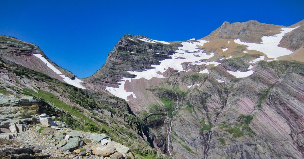
The trail starts climbing the southeast flank of 8,750-foot Fusillade Mountain as it ascends to Gunsight Lake. About one mile past the Florence Falls junction, the path emerges from the trees to reveal the majestic 10,052 foot Mount Jackson. George Bird Grinnell named this mountain after William Jackson who was the grandson of Hugh Monroe. Hugh Monroe worked for the Hudson’s Bay Company and is believed to be the first white to explore the country that is now Glacier National Park. Jackson was also a scout for Captain Reno at the time of the Custer Battle on the Little Bighorn.7
Situated on the northeast side of Mount Jackson is the 200-acre Jackson Glacier. Jackson is the 7th largest glacier of the 26 remaining glaciers in the Park. To the east of Jackson Glacier is the 400 acre Blackfoot Glacier which is the 2nd largest glacier of the 26. Both of these were once one. In 1850, this one glacier covered 1,875 acres.
Today’s relatively small moving masses of ice are not the remnants from the Great Ice Age of the Pleistocene Epoch (two million to about 12,000 years ago). The valley filling glaciers from that age are to be given credit for the beautiful mountain sculpting for which Glacier National Park is famous. The glaciers we enjoy today had their origin about 6,000 to 8,000 years ago and probably increased the most during the Little Ice Age which started about 400 to 500 years ago and ended in 1850.1
According to Dr. Dan Fagre, a USGS Research Ecologist in Glacier National Park, this area is experiencing a rise in temperature that is about two times the global average rise in air temperature.2 Paleoclimate research has revealed that the climate warming today is happening much more rapidly than the changes of the last two million years. NASA Earth Observatory states that interglacial warming during the past two million years averaged 5 ℃ over 5,000 year periods. The predicted rate for the next 100 years is at least twenty times that rate.3
When President Taft signed the bill in 1910 making Glacier the 10th national park, there were an estimated 150 glaciers. Today there are 26. One computer model predicts all of the glaciers will be gone by 2030.2
About 0.5 miles before Gunsight Lake, you will cross an extensive debris field that was deposited by a massive avalanche during the winter of 2010/2011. The trail has since been improved. So, no bushwacking should be necessary.
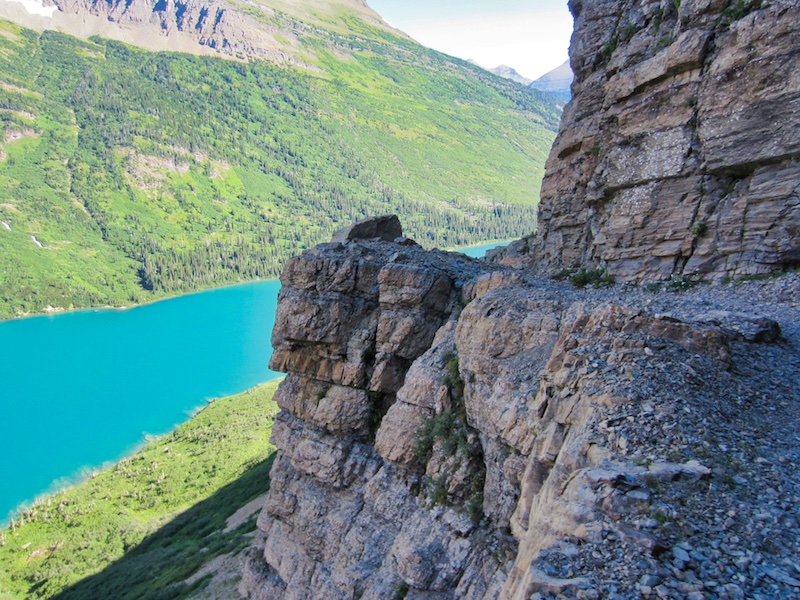
At the lake, you will find the backcountry campground which has six sites, three of which can be reserved. The camp usually opens around July 15. Look toward the head of the lake and enjoy the majesty of Gunsight Mountain (9,258 feet) and Mount Jackson (10,052 feet). The low point in between the two summits is Gunsight Pass (6,946 feet). Gunsight Lake is at 5,351 feet.

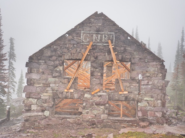
During 1910 to 1912, the Great Northern Railway (GNR) established a tent camp for its guests coming and going from the Sperry Chalets and Saint Mary. From 1910 to 1911, GNR constructed the Gunsight Lake Chalets including a dining hall/kitchen and a 50 guest lodge at a location between the backcountry campground and the lake outlet near the shoreline. These opened in 1911.5
Sometimes things are just not meant to be. During the offseason of 1913 to 1914, the dining room building suffered significant damage from a hungry grizzly bear. The loss was repaired. Then, sometime in March of 1916, buildings were destroyed in an avalanche. Reconstruction never happened.
Gunsight Lake to Lake Ellen Wilson
I think that I had a constant smile on my face during this section of the hike. We left behind the shores of Gunsight Lake and continued on across a long suspension bridge which spanned the Saint Mary River. My lungs demanded a lot of the pristine alpine air as we climbed the 2.8 miles and 1,595 feet to Gunsight Pass. At the same time, my eyes provided a nice distraction as they fed my brain with jaw-dropping beauty as we gained altitude along the northern flank of Mount Jackson. Gunsight Lake shrunk below us. Waterfalls were thundering down rock faces, sometimes hundreds of feet, to the north and south of us.

There are several snowfields below the pass that can persist well into August. Some are steep and need to be negotiated with caution especially early in the summer. Check the Glacier National Park trail report. If they recommend an ice-ax and crampons, take it seriously. Be sure to know how to use the equipment properly. Sliding down the frozen face of a steep snowfield toward a cliff is not the ideal time to learn how to self-arrest.
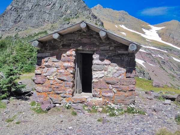
Upon arriving at Gunsight Pass (6,946 feet), you will be treated to views of Lake Ellen Wilson far below to the southwest, Gunsight Lake to the northeast, Gunsight Mountain to the north, and Mount Jackson to the south. The rock shelter there was built about the same time that the Going-to-the-Sun Road was completed in the early 1930s. It was constructed for a cost of $638 to provide a safe haven in times of severe weather for those traveling between the Sperry Chalet and Saint Mary.4 It is evident that maintenance has been kept up.
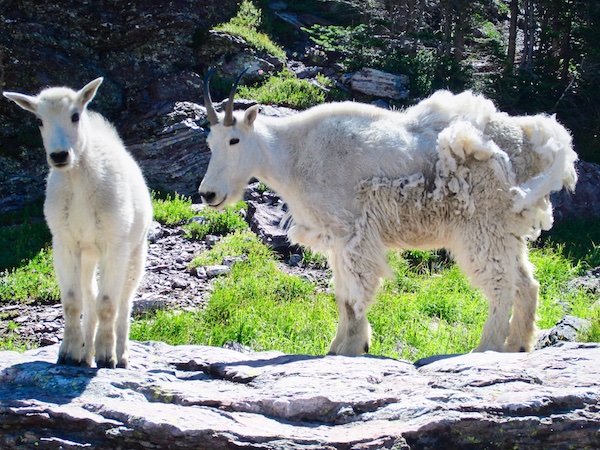
Don’t be fooled by the apparent amiable nature of the mountain goats that are likely to be encountered at the pass. Some can be a bit clingy. The apparent lack of fear is a red flag for me. It may be my imagination, but their behavior is a little different than those that I have encountered in other parts of the park. The photo opportunities are excellent though.
Gunsight Pass is about 9.3 miles from the trailhead and close to the halfway mark. From the pass, the trail descends 1,017 feet on its way to Lake Ellen Wilson. The trail distance is about 1.7 miles from the pass to the trail junction that leads to the backcountry campground at Ellen Wilson. There is a beautiful little waterfall and stream that the trail crosses toward the bottom of the descent. On our trip, we met a group of mountain goats that were coming up the path and wanted to cross the stream at the same place as us. There was no negotiation. We stepped off of the trail a reasonable distance and let them pass.
Lake Ellen Wilson belongs to a glacial cirque at 5,929 feet elevation. She is a little over a mile long and about one-half mile wide. According to Fishes of Glacier National Park Conservation Bulletin Number 22, the only fish species in Lake Ellen Wilson is the Eastern Brook Trout. I can attest to the fact that they will rise to a fly. The backcountry camp has four sites of which two can be reserved. The camp usually opens around August 1.

The outlet empties into Lincoln Lake 0.25 miles away as a bird flies, but only after a spectacular 1,300-foot drop. Beaver Chief Falls is the name given to these thundering cascades. This picturesque lake was named in honor of President Woodrow Wilson’s first wife who died in 1914, the year following her husband’s inauguration.7
Lake Ellen Wilson to Lake McDonald Lodge Parking Lot
The hike from the Lake Ellen Wilson backcountry campground trail junction to Lincoln Pass is 2.3 miles and 1,121 feet of elevation gain. The pass, at 7,050 feet, is the highest point along this hike. From the pass, it is an easy 1.2 miles with 550 feet of elevation loss to the Sperry Chalet. If luck is with you, there may be some freshly baked huckleberry pie left for purchase at the kitchen and dining hall.
The two-story Sperry Chalet and the separate dining room/kitchen were completed in 1913 by the Great Northern Railway. They are built of native stone which was quarried from a talus slope behind the buildings and extending to the south. Both of the buildings are National Historic Landmarks. The only other remaining backcountry hotel in the park is the Granite Park Chalet situated on the Garden Wall.
The Sperry Chalet was named for Dr. Lyman B. Sperry from Oberlin College in Ohio. The gentleman explorer and ardent supporter of the national park concept led the first group of people to the glacier that now bears his name in 1896. He also negotiated a deal with the Great Northern Railroad to provide transportation to and from the park, tents, food, and supplies for himself and students. In return, during the seasons of 1902 and 1903, he and the volunteer students built a trail from Lake McDonald to Gunsight Pass with a spur trail to Sperry Glacier.7
On August 17, 2017, the Sperry Chalet was gutted by the 16,000-acre Sprague Fire. Reconstruction is now underway and is anticipated to be completed by the end of the 2019 summer.
A notable side trip from the chalet complex is the 2.7 mile, 1,500-foot climb to Comeau Pass and then another half mile from the pass to view the glacier. Allow at least six hours for a round trip.
Once you leave the chalet en route to the Lake McDonald Lodge parking lot, it is a 3,286-foot elevation drop over 6.1 miles. Your knees may whine a little by the time the trailhead arrives. The route is mostly in the trees along the Sprague Creek drainage on the south side of Mount Edwards and Mount Brown.
A great way to cap off an extraordinary day of hiking is with a refreshing beverage on the terrace of the historic lodge overlooking Lake McDonald.
Glacier National Park Guidebooks
Maximize Your Adventure: Learn about the diverse recreational opportunities available along the Going-to-the-Sun Road, including hiking, biking, boating, and more. A small price to pay for endless outdoor experiences.
From Novice to Expert, We’ve Got You Covered: For the price of a huckleberry shake, you’ll have everything you need to plan and execute your adventure in Glacier National Park’s east side.
End Notes
- Fagre, Daniel B. “History of Glaciers in Glacier National Park.” U.S. Geological Survey. Accessed September 8, 2018. https://www.usgs.gov/centers/norock/science/history-glaciers-glacier-national-park?qt-science_center_objects=0#qt-science_center_objects.
- Fagre, Daniel B., and Lisa McKeon. “Retreat of Glaciers in Glacier National Park.” U.S. Geological Survey. Accessed September 8, 2018. https://www.usgs.gov/centers/norock/science/retreat-glaciers-glacier-national-park?qt-science_center_objects=0#qt-science_center_objects.
- NASA Earth Observatory. “How is Today’s Warming Different from the Past?.” Accessed September 8, 2018. https://earthobservatory.nasa.gov/Features/GlobalWarming/page3.php.
- National Archives Catalog. “Montana MPS Gunsight Pass Shelter.” Accessed September 8, 2018. https://catalog.archives.gov/id/71974944.
- National Park Architecture Society. “Gunsight Chalets.” Accessed September 8, 2018. http://www.nplas.org/gunsight.html.
- Raup, Omer B., Robert L. Earhart, James W. Whipple, and Paul E. Carrara. “Geology Along Going-to-the-Sun Road Glacier National Park, Montana.” Glacier Natural History Association.
- Robinson, Donald H. Through the Years. 5th ed. West Glacier, MT: Glacier Natural History Association, 1973.
- World Waterfall Database. “Florence Falls.” Accessed September 8, 2018. https://www.worldwaterfalldatabase.com/waterfall/Florence-Falls-748.

One response to “Gunsight Pass Trail, Point-to-Point Hike”
I wanted to thank you for this fantastic read!! I certainly loved every little bit of it. I have you book marked to check out new things you post…
LikeLike