This 18-mile hike, which crosses the Continental Divide from east to west and then back over again, is spectacular. It includes walks through subalpine forests, mountain meadows, and high windswept alpine ridges with panoramic views into the craggy park interior. There is also a high probability of seeing moose and bighorn sheep.
Trailhead
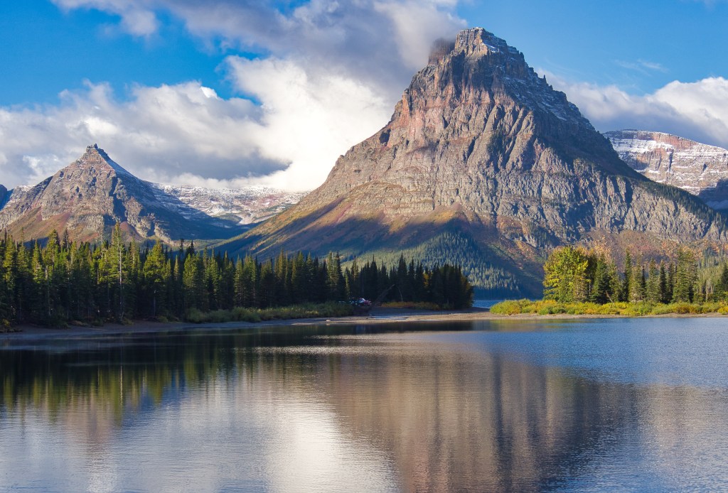
This tail is located in the Two Medicine Valley of the southeast region of Glacier National Park. Find the Two Medicine Campground and then the parking lot near Pray Lake. This will be both your beginning and ending location – assuming that you do not decide to motor across the lake on the Sinpopah launch.
Clockwise or Counterclockwise?
Since this is a loop, it can be hiked clockwise or counterclockwise. I have found that there are pros and cons for both directions.
Clockwise (Dawson Pass first)
Pros
- The light for photography tends to work better in this direction
- Most of the elevation gain is accomplished in the two miles just before the pass. The rest of the hike is relatively level or downhill.
Cons
- Toward the end of the 18 miles, there is a small ridge on the east flank of Rising Wolf Mountain that must be climbed.
Counterclockwise (Pitamakan Pass first)
Pros
- The 2,400-foot elevation gain to Pitamakan Pass is spread out over 7.6 miles.
- There is an option to catch a ride on the Sinopah across Two Medicine Lake at the end of the day. This could reduce the mileage of the hike by about 3 miles.
Cons
- The steep descent from Dawson Pass can be a killer for some people’s knees.
A Few Things to Consider
First, be honest about your hiking ability and physical condition. If you are not in shape, postpone this one for another day. There are plenty of other hikes to enjoy that will be more in line with your ability.
This trek can take 9 to 10 hours. You want to make sure that you are not hiking in the dark. Not a prudent plan. It’s a good idea to check sunrise/sunset tables when you are planning for the trip.
The route covers 18 miles with over 5,000 feet of elevation gain and loss. So, don’t skimp on the energy that your body will require. Bring the amount of food that you think you will need and then throw in a little extra. There will be no water for a good part of this trip. Prepare accordingly. It wouldn’t hurt to include a water filter to use on the latter part of the journey when you do have access to water.
Be prepared for quick weather changes. Parts of the trip will be above 7,000 feet. The last time I did this hike, it was excellent autumn weather at the beginning and snow and blowing snow around the passes. Bring clothes that can be combined in layers. Include a hat, gloves, and some sort of a windbreaker jacket and pants. The wind can blow pretty hard up there.
Use common sense on extremely windy days. There will be some parts of the trail that are narrow with long steep drop-offs. Call it a day before you get into trouble. The mountain is not going anywhere.
Trekking poles are a good idea for a balance aid, especially on windy days. Some people claim that they help with knee pain on descents.
Finally, bring bear spray. Make sure that it is quickly available and know how to use it. On our last trip, we saw bear scat on the trail in more than one place. Parts of the route were posted with signs warning of grizzly bears frequenting the area. Additionally, it’s recommended to hike in a group and always make plenty of noise.
The rest of this post will describe the hike going in a clockwise direction – starting with the 6.5 mile and 2,435-foot climb in elevation to Dawson Pass.
The Hike
From the parking lot, walk about 300 feet toward the foot of Pray Lake and cross the bridge over Two Medicine Creek. Continue another 300 feet to the ‘T’ in the trail. Go left. You will then be on the Dawson Pass Trail.
The trail proceeds in a general southwest direction. The enormous red hulk of Rising Wolf Mountain will be on your right. To the southeast across Two Medicine Lake and proceeding clockwise are Never Laughs Mountain, Grizzly Mountain, Painted Tepee Peak, and the majestic Sinopah Mountain.

The beautiful mountain at the head of Two Medicine Lake was named after Sinopah, a Blackfeet Indian maiden. She married Hugh Munroe, a Hudson’s Bay trapper and trader who lived with her people for some time. The Blackfeet gave him the name Rising Wolf for which the mountain was named.2
The rock that makes up these great mountains in the park was formed over an 800 million year time span which began 1.5 billion years ago. During that time, sediment was eroded from the surrounding lifeless land and deposited into the ancient Belt Sea. That sea was located where eastern Washington, northern Idaho, and western Montana are today. Preserved ripple marks and mud cracks in some of the formations are a testament to the water environment of that very distant past.3
The surrounding mountains have a lot of red color in them. That is the rock of the Grinnell Formation. The color was caused by oxygen reacting with the iron in the fine sediment that was deposited in the shallow water environment. The Grinnell has many ancient ripple marks and mud cracks.3
Starting in the Jurassic Period, 150 million years ago, and continuing into the end of the Cretaceous Period, 60 million years ago, Earth’s tectonic plates shoved a mass of rock several hundred miles wide and several miles thick 50 miles to the east.3
The magnificent horns, aretes, cirques, and u-shaped valleys that we enjoy today are the results of continent size glaciers working on the rock deposited here by the tectonic forces. The glaciers scraped and gouged from about 2 million years ago until 12,000 years ago.3 Glacier National Park, the sculpted masterpiece, is now sought by visitors from around the world.
The vistas that we seek out today in Glacier National Park have been in the making for the last one-third of the Earth’s entire existence.
At about 3.1 miles, you will come to a junction with a trail that exits on your left. This will lead to the South Shore Trail and the dock for the Sinopah launch at the head of the lake. This path will also connect with the trail to Upper Two Medicine Lake. Stay right. On our last trip, after this junction, we met a red fox trotting down the path and encountered a bull moose laying where we needed to walk.
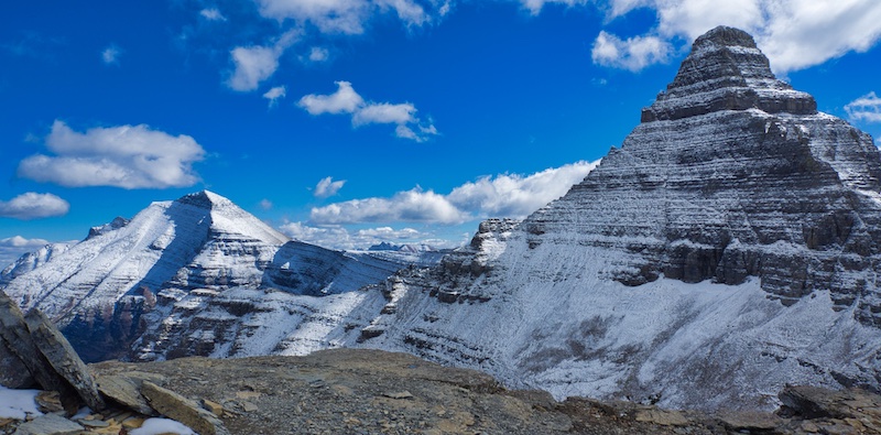
The spur trail to No Name Lake will be found at 4.6 miles from the trailhead. After this, the route gets steep. You will climb through the Bighorn Basin via a series of switchbacks. As you continue to gain elevation, Flinsch Peak, a glacial horn, will come into view to the northwest. You will notice that Flinsch is not red. It’s tan colored limestone is of the Siyeh Formation. This rock is above and younger than the argillite of the Grinnell Formation.3
In the limestone rock near Dawson Pass, we found fossilized cyanobacteria colonies commonly known as stromatolites. Although the fossils are not this old, these single-celled photosynthetic organisms have been living on our planet for over 3 billion years.1 These simple creatures are mostly responsible for the Earth’s atmosphere becoming more oxygen rich and less carbon dioxide saturated.6 They are not as abundant as they once were, but places like Shark Bay in Western Australia still support these tiny oxygen factories.
At 6.5 miles and 7,598 feet in elevation is the rocky, windswept Dawson Pass. There is a rock cairn marking the site. You will also find a rough rock wall that can provide a little shelter from the wind. The views are magnificent and include park icons such as the spire of Mount Saint Nicholas to the southwest and Mount Stimson to the west.

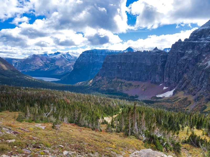
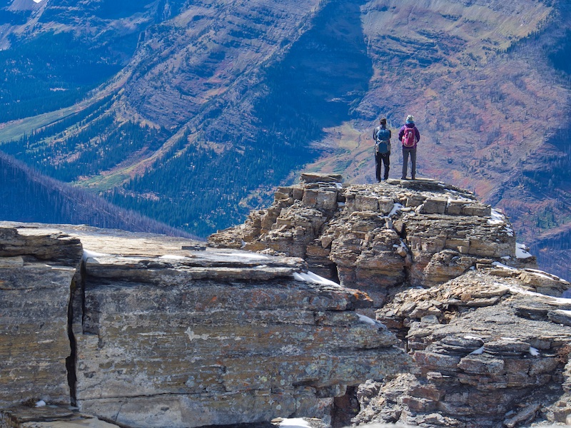
From Dawson Pass, the path heads north and is basically benched into the steep, barren, rocky, western slope of Flinsch Peak. The Pitamakan Overlook is toward the north end of this segment where the trail juts out west and then abruptly back to the east. This is part of a steep ridge belonging to Mount Morgan. If you aren’t concerned with exposure, make your way out to the end of the overlook for a breathtaking vantage point.
The trail continues to the northeast and wraps around the northern slope of Mount Morgan before descending to Pitamakan Pass.
Pitamakan was a famous female Blackfeet warrior. Born Otaki, the male name Pitamakan or Running Eagle was bestowed on her by Chief Lone Walker for her bravery in battle. Running Eagle Falls are also named for her.4 It is in the cave of rushing water, Running Eagle Falls, that she committed herself to a vision quest which changed her life. She renounced marriage and devoted her life to the service of her people.5
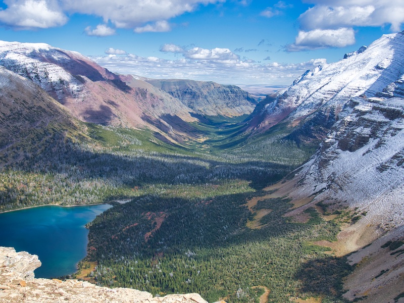
Hundreds of feet below the pass to the north are two alpine gems – Seven Winds of the Lake and Pitamakin Lake. There is a trail, accessed from near the pass, that leads between these two lakes and down the North Fork of Cut Bank Creek to the backcountry campground near Morning Star Lake. This is part of the Continental Divide Trail. Staying on this footpath will lead over Triple Divide Pass, to Saint Mary Lake, Many Glacier, and eventually, Goat Haunt at the Canadian Border.

From the pass, it is a 7.6-mile downhill trek in the Dry Fork drainage back to the trailhead. This section is also part of the Continental Divide Trail. The spur trail to Old Man Lake will appear on your right about 1.5 miles from the pass. The massive mountain to the south is Rising Wolf. The circumnavigation of this enormous landmark is almost complete.
About 4 miles from Pitamakin Pass or 15.5 miles from the beginning, there is another trail junction. Proceeding straight ahead for 2.8 miles will put you at the Two Medicine Entrance Station. Take the right fork toward the Two Medicine Campground. Within this last section, there will be a bit of a climb over a ridge that extends from Rising Wolf Mountain.
Hopefully, when you reach the end of the trail and your vehicle, there are refreshments and other goodies waiting in a cooler for you. There is much to celebrate!
Glacier National Park Guidebooks
Your Ultimate Guide to Going-to-the-Sun Road: Invest in your adventure and unlock the full potential of opportunities along this iconic road. For less than the price of a movie, a lifetime of memories.
Don’t guess, know. Tom Berquist, a local with nearly 1,000 miles hiked in Glacier, provides the reliable information you need to explore the east side of the park in this comprehensive and trustworthy guide.
End Notes
- Awramik, Stanley M., and James Sprinkle. “Proterozoic stromatolites: The first marine evolutionary biota.” Historical Biology13, no. 4 (May 8, 2009): 241-53. Accessed October 1, 2018.
- Guthrie, C.W. The First 100 Years. Helena, MT: Farcountry Press, 2008.
- Raup, Omer B., Robert L. Earhart, James W. Whipple, and Paul E. Carrara. Geology Along Going-to-the-Sun Road Glacier National Park, Montana. West Glacier, MT: Glacier Natural History Association, 1983.
- Robinson, Donald H. Through the Years: in Glacier National Park. 5th ed. West Glacier, MT: Glacier Natural History Association, Inc., 1973.
- Schultz, James W. Running Eagle: the warrior girl. 1919.
- “Stromatolites.” Accessed October 1, 2018. http://www.indiana.edu/~geol105b/images/gaia_chapter_10/stromatolites.htm.
