An adventure for the books! The 31-mile land segment of our journey started in the northwest corner of Glacier National Park and followed the Boulder Pass Trail to Goat Haunt in the north-central region of the park. From there we motored about 7 miles north on Waterton Lake to the docks in Waterton, Alberta, Canada via the 165 passenger boat the M.V. International built in 1927.
Our journey took us over two mountain passes and along four pristine mountain lakes all the while surrounded by majestic, jaw-dropping scenery. Finally, we crossed the international boundary at the 49th parallel which was negotiated with Great Britain in 1846. It wasn’t planned at the time, but this ended up being part 1 of a 2 part trek from the west side of the park to the east side.
Permits
For this backpacking trip, we needed a permit for each of the three specific campgrounds that we intended to use – Upper Kintla Lake, Hole-in-the-Wall, and Lake Janet. Lake Francis was not available to us. If you can get Francis, take it instead of Janet. You will not regret it.
One-half of the sites are available on a walk-in basis the day before or the day of a trip. At this writing, the fee was $7/person/night. Although the Polebridge Ranger Station is a permitting location, I would suggest that you have the permit in hand before driving all the way to Polebridge. For up-to-date information on securing backcountry campsites visit Glacier National Park’s Wilderness Camping webpages.
The tickets for the boat into Canada can be purchased from the Waterton Shoreline Cruise Company. You will need a passport to enter Canada.
It Needs to Start at Polebridge
As any local knows, you cannot venture into this region without first stopping at the Polebridge Mercantile located just outside the park boundary. There will probably be someone around by 7 AM. Might I suggest their Huckleberry Bear Claws and a cup of coffee? If you arrive around dinner time, check out the Northern Lights Saloon and Cafe located next to the Merc. I doubt that you will be disappointed.
By the way, if the Mercantile seems pretty old, it is. Bill Adair built the Merc in 1914. Local folks back then knew it merely as Adair’s. Bill and his wife worked the store and lived in their homestead cabin which is now the Northern Lights Saloon and Cafe. These buildings are now part of the W.L. Adair General Mercantile Historic District which was placed on the National Register of Historic Places in 1986.1
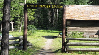
Kintla Lake
Upon leaving Polebridge, we drove eastward and crossed the North Fork of the Flathead River where we entered Glacier National Park. From there we drove north for about 15 miles to reach the Kintla Lake campground. Our kind friend who had volunteered to deliver us to the trailhead cut us loose and headed back to Kalispell. The plan was to get an early start the next day. So, that left a little time to explore.
We met the ranger in charge, Lyle Ruterbories, who was in his mid-nineties and still at it. What a treat it was to talk to him and listen to the stories he had to tell. It turns out that the ranger station at Kintla Lake was built ten years before the area became Glacier National Park. The construction was done by the Butte Oil Company in 1900 after oil seeps had been discovered along Kintla Lake.
The oil company hired men to clear a wagon trail from Apgar to the south shore of Kintla Lake. In the autumn of 1902, crews hauled drilling equipment to the foot of the lake. When there was enough ice on the lake, the load was skidded to the drill site. The oil well was the first in Montana. But, it never worked out and was abandoned.
Long before Europeans came to this country, the Kootenai used the land that is now Glacier National Park for thousands of years – back to the Late Pleistocene. In her book, People Before the Park, Sally Thompson explains that the Kootenai used 11 mountain passes to travel east of the continental divide to hunt buffalo. One of those passes was Brown Pass which was accessed either from the Bowman Lake drainage or Boulder Pass side.4 It is interesting to imagine what life was like for those hardy people that regularly used the same general path on which we were about to embark.
Bear Safety
This is grizzly bear habitat. Always carry bear spray where it is immediately available and practice removing the canister from its holster. Be sure that any packaging material has been removed from the safety clip and that you can remove the clip safely and quickly. The time to learn is not when you have a bear encounter. Make plenty of noise to alert bears of your presence. Surprising a bear can ruin your day.
Glacier National Park has a great Bear Safety webpage.
Kintla Lake to Upper Kintla Lake (11.5 miles)
After an early breakfast, we began our hike to Upper Kintla Lake. There is only an average elevation gain of about 100 feet per mile, which made for a decent first day. At times, you’ll be treated to sweeping views of the Boundary Mountains and Long Knife Peak to the north. Close to the head of the lake, is the Kintla Lake backcountry campground. Not too far from the food prep area and sticking out of the gravel shoreline is a piece of equipment left behind by the Butte Oil Company.

The first oil well not far from the shore of Kintla Lake reached a final depth of 1400′, but in the winter of 1902-03, almost the whole works burned. The well never reached a profitable pocket of oil. In 1912, all claims of the Butte Oil Company were declared void. Another company built a derrick near the North Fork River several miles below Kintla Creek, but it stopped drilling in 1903 due to a lack of capital.3
The trail leaves the lake and soon passes a patrol cabin as it gently climbs to some open benches. Watch for signs of the lightning-caused 2003 Wedge Canyon Fire which consumed 52,974 acres during the most significant fire season in Glacier National Park’s history. More than 13% of the park burned during “The Summer of Fire”.
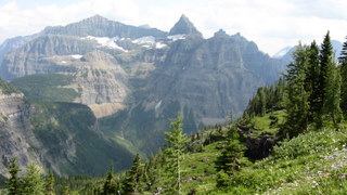
Views to the south-east are dominated by the magnificent Kintla Peak and the glacial horn Kinnerly Peak. The mountain to the east, which resembles the comb on the head of a rooster, is Gardner Point. The Boulder Pass Trail climbs up the south-west flank of that beauty.
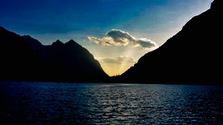
Arriving at the backcountry campsite after a full day is always a nice reward. It had been a pretty warm day. The lake beckoned, and we obliged. This day was topped off with a freeze-dried meal, that only seems delicious in the backcountry, a magnificent sunset, and a deep sleep that most often comes to me when I’m in the mountains.
Upper Kintla Lake to Hole in the Wall (8.6 miles)
On the second day, the trail more than made up for the small amount of elevation gain of the first day. Our destination was the Hole-in-the-Wall campground found in the bottom of a glacial cirque of the same name.
Not long after leaving Upper Kintla Lake, we crossed a suspension bridge over Kintla Creek and began our 6.1-mile and 3,070-foot climb to Boulder Pass. We hiked through thimbleberry and cow parsnips (bear candy) some of which was 5 feet tall or more. At times, the lush growth obscured the trail.
We took a little break and grabbed a bite to eat at the Boulder Pass Campground. The talus field below the campground is home to pikas. These cute furry animals are about the size of a large baked potato and are a relative to rabbits. Their physiology makes heat an enemy. There is evidence that climate change has adversely affected some populations in the western United States. Glacier National Park is in the process of determining the health of pika populations within the park. I volunteered to collect data during this trip that will go toward this effort.

This is also an excellent place to see mountain goats which is another species that doesn’t do well with heat. Park biologists are collecting data to determine patterns in the population of this species as well. So, we spent some time counting numbers, determining sex, and age groups within our observation grid.
From Boulder Pass, it’s a 3.5-mile and 1,090-foot descent into the Hole-in-the-Wall cirque. The rock that we were walking over, like the rest of the Park, was formed from sediment that was deposited in the ancient Belt Sea which would have been located where eastern Washington and western Idaho are today. Starting about 1.6 billion years ago, the 18,000 feet of sediment, that would become Glacier National Park, was eroded from land that had not yet seen life. The erosion and deposition continued until about 800 million years ago. Then, approximately 150 million years ago, incomprehensible tectonic forces started to shove the enormous rock slab 50 miles eastward. That movement continued until about 60 million years ago.2
It’s cool to see part of the story laid out along this trail by mother nature. The reddish colored rocks with ripple marks or mud cracks look like they were recently made, but are over a billion years old.

There are also strange circular patterns in the stone. These are fossilized algae called stromatolites. The single-cell photosynthetic microorganisms that made the structures lived in the shallows of the sea much as they do today. These simple organisms played a significant role in forming the oxygen-rich atmosphere that life today depends on.
But wait, there’s more. Over two million years ago, the Earth entered a cooling period. This was the Pleistocene Epoch, and it lasted until about 12,000 years ago. It was the time of the “Great Ice Age” when valley deep glaciers advanced and retreated many times. The beautiful rock that was born in the Belt Sea and shoved eastward was then sculpted by the glaciers into the quintessential horns, aretes, cirques, u-shaped valleys, hanging valleys, and moraines that we take delight in today.
Once you reach the edge of the Hole-in-the-Wall cirque, there are incredible views of Thunderbird Mountain and The Sentinel to the south. Enjoy these views and those of numerous waterfalls as you descend. Keep an eye out on the east side of the cirque for the short spur trail that leads down to the campground.
This magnificent place to spend the night has some ornery mule deer that are pretty persistent when it comes to getting salt. So, don’t leave any hiking poles or sweaty t-shirts lying about the campsite. At Stoney Indian, we actually did have a mule deer doe pick up and carry off a hiking pole. An observant fellow camper went after the deer and recovered it while we were in the meal prep area.
You will no doubt discover this on your own, but I challenge you to find a privy anywhere that has the views of the one at Hole-in-the-Wall. Note that privy implies walls. There are none – just a simple box with a lid placed over a hole.
Hole-in-the-Wall to Lake Janet (7.0 miles)
It was hard to leave Hole-in-the-Wall behind. We started climbing out of the cirque along the southwest flanks of Mount Custer and then Chapman Peak and then descended to the vast subalpine meadows of Brown Pass. Here the Bowman Lake Trail intersects with the Boulder Pass Trail that we had been following for two days. Our path continued to drop in elevation as we headed down into the Olson Creek Valley to the east. It is a beauty. The trail passes close to Thunderbird Pond which provided a great photo op. Looking east above the pond, Mount Cleveland dominates the skyline, and the sharp pinnacles of Citadel Peaks rise in the foreground.
We were not lucky enough to land a camping site at Lake Francis, but the lake is only a short jaunt down a spur trail off of the Boulder Pass Trail. It was well worth the time to visit the lake. From the clean gravel beach, we looked across the water to the towering cliffs of The Sentinel and a waterfall thundering hundreds of feet into the beautiful turquoise water of Francis. The waterfall is fed by the glacial melt of what is left of Dixon Glacier. Words nor pictures can do justice to that scene.

The short 7-mile day ended at Lake Janet. This campground is not on the lake, but the food prep area is near a shaded stream. We found bear tracks along the creek but never did see the bruin. The unusually high cable for hanging food provided entertainment for the impromptu contest to see who could toss their weighted cord over it with the fewest number of tries.
Lake Janet to Goat Haunt (4.3 miles)
There is a talus field with pika about one mile east of the Lake Janet campground. This was our second site for data collection.
After a short day, we arrived at Goat Haunt which is about 2,000 feet lower than Brown’s Pass. We boarded the M.V. International shortly after arriving at the dock, and then the rain and wind started. Talk about luck! During our 7-mile northward journey on Waterton Lake, the captain slowed as we passed the international boundary. It looked like someone had taken a giant razor to cut the swath through the trees.
After the boat arrived at the docks in Waterton, Canada, it was about another half hour of waiting so that officials could check our passports and backpacks. Then, it was off to a local establishment for a cold brew and burger to wait for our ride back home.
Life is good!
Glacier National Park Guidebooks
Experience the magic of Going-to-the-Sun Road with this expertly crafted guide. Discover recreation opportunities, enjoy breathtaking views, and create a personalized itinerary that suits your travel style. Discover Glacier at your own pace. Order now and embark on an unforgettable journey through Glacier National Park.
Ready to explore? Tom Berquist, a local with nearly 1,000 miles of hiking the trails of Glacier under his belt, provides practical insights, detailed maps, wonderful photos, and valuable planning information. This guide is your trusted companion for an unforgettable East Side adventure.
End Notes
- “Montana SP Adair, W. L., General Mercantile Historic District.” National Archives Catalog, Department of the Interior, National Park Service, Feb. 1986, catalog.archives.gov/id/71975962. Accessed 23 July 2018.
- Raup, Omer, Robert Earhart, James Whipple, and Paul Carrara. Geology Along the Going-to-the-Sun Road Glacier National Park, Montana. West Glacier, MT: Glacier Natural History Associaton, 1983.
- Robinson, Donald. Through the Years. 5th ed. West Glacier, MT: Glacier Association, 1973.
- Thompson, Sally. People Before the Park. Helena, MT: Montana Historical Society Press, 2015.
