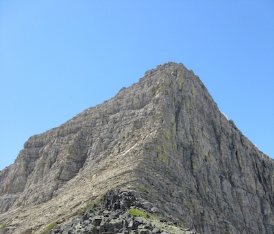
This out and back hike leads to a very unique location in North America. Triple Divide Peak (8,020 feet), which towers above Triple Divide Pass (7,397 feet), is referred to as the hydrologic apex of North America. This is where the Continental Divide and the Northern Divide intersect.
Water draining down the west side of the peak travels to the Pacific Ocean via Pacific Creek, the Middle Fork of the Flathead River, the Clark Fork River, Pend Oreille River, and finally the Columbia River. Water flowing down the northeastern side drains to Hudson Bay via Hudson Bay Creek, Medicine Owl Creek, Red Eagle Creek, Saint Mary Lake, Saint Mary River, Oldman River, Saskatchewan River, and the Nelson River. Water on the southeastern slopes of Triple Divide Peak flows to the Gulf of Mexico by way of Atlantic Creek, the North Fork of Cut Bank Creek, the Marias River, Missouri River, and the Mississippi River.

The Trailhead
The turn to the Cut Bank area is located between St. Mary and Two Medicine. Travel about 14 miles south from Saint Mary along highway 89 or north of East Glacier approximately 16 miles along the same road. There is a five-mile-long gravel road that leads to the ranger station, campground, and the trailhead.
The Cut Bank Ranger Station, built in 1917, is one of the first buildings constructed by the National Park Service (NPS) in Glacier National Park and is listed on the National Register of Historic Places. The station had a permanent year-round ranger until the late 1930s when the NPS made the decision to staff the ranger station only during the summer months. In 1935, the ranger station barn was built by the Civilian Conservation Corps for about $1,300.1
West of the ranger station is the Cut Bank Campground. This no-frills, 14 site campground does have a vault toilet, but no potable water. The North Fork of Cut Bank Creek is nearby. So, filtering or boiling your water is an option. RV’s and truck trailer combinations are not recommended.
The trailhead is located close to the campground. However, there is not an abundance of parking spaces. This entry into Glacier National Park will give you access to other trails that will lead both north and south along the eastern side of the park.
This is grizzly bear habitat. Always carry bear spray where it is immediately available and practice removing the canister from its holster. Be sure that any packaging material has been removed from the safety clip and that you can remove the clip safely and quickly. The time to learn is not when you have a bear encounter. Make plenty of noise to alert bears of your presence. Surprising a bear can ruin your day.
Glacier National Park has a great Bear Safety Web page at https://www.nps.gov/glac/planyourvisit/bears.htm.
The hike from the Cut Bank Trailhead to Triple Divide Pass climbs 2,380 feet over 7.2 miles.
On the Trail – The Easy Part
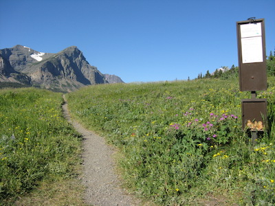
The hike to Triple Divide Pass starts off through meadows that can be loaded with wildflowers. The trail roughly follows the North Fork of Cut Bank Creek in a southwest direction. Bad Marriage Mountain (8,350 feet) fills most of the skyline to the south. At 3.9 miles from the trailhead, you will come to a trail junction. Going left, to the south, will take you to Morning Star Lake and Pitamakin Pass. Stay right for Triple Divide. From this location to the pass, you will be on a section of the Continental Divide Trail which stretches 3,100 miles from Mexico to Canada. The Atlantic Creek backcountry campground is just a short distance up the trail at 4.2 miles. While you are still relatively close to water, you may want to consider replenishing your supply.
At 4.6 miles, there is another trail junction. The trail to the left leads to Medicine Grizzly Lake. Stay right to continue on to Triple Divide Pass. If you are interested in visiting Medicine Grizzly Lake, it is about 1.4 miles from the junction to the foot and 1.9 miles to the head of the lake. This beautiful lake has numerous waterfalls plunging toward it from Triple Divide Peak, Razoredge Mountain (8,570 feet), and Medicine Grizzly Peak (8,315 feet).
The lake gets its name from the Blackfeet Legend of Medicine Grizzly. According to this legend, a Blackfeet warrior named Nis-ta-e was severely wounded while trying to escape with horses that he and fellow Blackfeet had stolen from the Snake tribe. A grizzly bear found him and supplied him with food. When Nis-ta-e was strong enough, the bear carried him on his back to a location close to his people. The bear asked that in return for saving Nis-ta-e that neither he nor his people would kill a hibernating bear.2
On the Trail – The Tougher Part
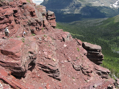
From the junction to Medicine Grizzly Lake, it is about 2.6 miles to Triple Divide Pass. Don’t count on access to water from here on. The trail climbs up the southern flank of Mount James (9,375 feet) and gains about 2,000 feet in elevation by the time it reaches the pass. The scenery is spectacular. The view looking down on Medicine Grizzly Lake with water cascading hundreds of feet down the headwall is quintessential Glacier. Be sure to keep an eye out for bighorn sheep and mountain goats.

At 7.2 miles, relish the views from the pass back to the southeast along the Atlantic Creek drainage or to the north along the Hudson Bay Creek valley. While looking north, you should be able to see signs of the 2006 Red Eagle Fire that burned over 32,000 acres. This fire burned to the northeast and out of the park and onto the Blackfeet Reservation. From the pass, the notable Triple Divide Peak rises 621 feet to the west and Mount James 1,980 feet to the east.
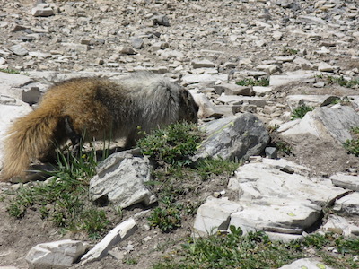
In addition to bighorn sheep and mountain goats, hoary marmots are also inhabitants of this area. When we sat for lunch, the marmots didn’t waste any time positioning themselves for an irresponsible handout. Please don’t feed them.
Hike Summary
| Total Distance: 14.2 miles |
| Total Elevation Gain: 2,610 feet; Loss: 399 feet |
| Difficulty: 19.4, strenuous * (Calculated using Petzoldt’s Energy Rated Mile equation.) |
| Estimated Walking Time: 7 hours (Calculated using an average speed of 2.5 mph and Naismith’s correctionfor elevation gain.) |
Options
With some planning, this hike could be extended into a nice overnighter. Continue north down the Hudson Bay Creek valley 7.8 miles to the head of Red Eagle Lake. There is a backcountry campground there with four sites – two of which are reservable. Or, add another 0.8 miles to reach the foot of the lake and another backcountry campground with the same number of sites.
From the foot of Red Eagle Lake, it is 8.1 miles to the trailhead which is located at the parking area for the historic 1913 St. Mary Ranger Station – built three years after the establishment of Glacier National Park and three years before the creation of the National Park Service.3
End Notes
1. “Cut Bank Ranger Station Historic District.” National Register of Historic Places, United States Department of the Interior, npgallery.nps.gov/NRHP. Accessed 10 July 2018.
2. McClintock, Walter. “The Old North Trail.” Sacred-texts, MacMillan and Co., Limited, 1910, http://www.sacred-texts.com/nam/pla/ont/ont39.htm. Accessed 10 July 2018.
3. “St. Mary Ranger Station.” National Register of Historic Places, United States Department of the Interior, npgallery.nps.gov/NRHP. Accessed 10 July 2018.
