In my last post, I described our backpacking trip from Kintla Lake in the northwest corner of Glacier National Park to Goat Haunt in the northcentral part of the park. This post will be about the second leg of the northern traverse beginning at Goat Haunt and ending at Chief Mountain – 28 miles.
The 1927 M.V. International was again our transportation. She transported us from Waterton, Canada south across Waterton Lake and delivered us to Goat Haunt in the United States.
A Note on Bear Safety
This is grizzly bear habitat. Always carry bear spray where it is immediately available and practice removing the canister from its holster. Be sure that any packaging material has been removed from the safety clip and that you can remove the clip safely and quickly. The time to learn is not when you have a bear encounter. Make plenty of noise to alert bears of your presence. Surprising a bear can ruin your day.
Glacier National Park has a great Bear Safety webpage.
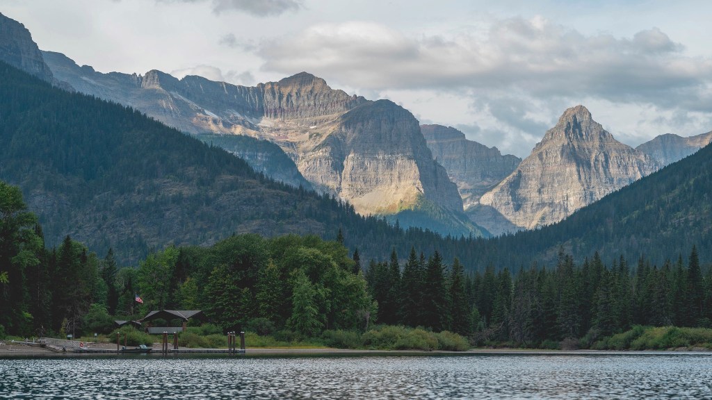
Goat Haunt to Waterton River Campground (1.2 Miles)
After we arrived at Goat Haunt in the afternoon, we proceeded to the Waterton River campground and set up camp. Since there was still daylight, we hiked to Rainbow Falls which was about 1.1 miles roundtrip. The only wildlife we spotted was a bald eagle and a small doe with her spotted fawn.
Waterton River Camp to Stoney Indian Lake (8.1 miles)
The next morning we pointed our boots south down the Waterton Valley Trail. There is a short spur trail to Kootenai Lakes at about 2.5 miles. Kootenai Lakes is supposed to be an excellent place to spot moose. However, there were no moose for us. But, we did see some dandy mosquitos.
Porcupine Ridge and the distinctive Citadel Peaks can be observed to the west. The junction for the challenging trail to the Porcupine Fire Lookout is about 1.5 miles beyond the Kootenai Lakes spur.
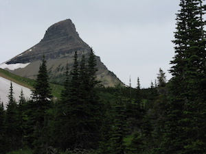
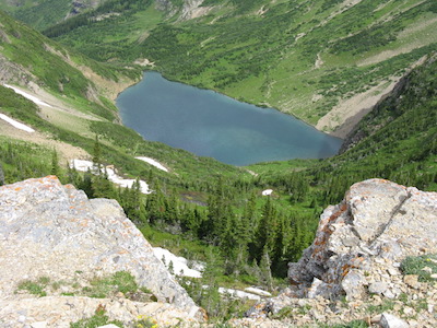
The Stoney Indian Pass Trail junction is about 0.9 miles past the Porcupine Fire Lookout trail junction. This steep footpath begins at about 4,600 feet of elevation and climbs east up the Pass Creek Drainage arriving at Stoney Indian Lake, elevation 6,325 feet, in 2.3 miles. I forgot all about the climb when I saw the beauty of this glacial tarn guarded by majestic mountains especially the glacial horn – Wahcheechee Mountain.
The stunted alpine trees at the foot of the lake surround the campsite which is on the south side of the trail. The food preparation area is found north of the trail.
Entertainment for the evening was provided by the local deer. We were returning to the campsite after hanging our food in the food preparation area when a fellow camper walked into our site carrying a hiking pole that belonged to my friend. He told us that he saw a deer pick it up and trot off with it. He chased after the deer which promptly dropped the hiking pole. After cooking dinner that evening, we returned to the campsite to find a deer standing in the middle of my pack licking the back. Those deer were emboldened by their craving for salt.
I was curious about the Stoney Indians after whom the lake and pass were named. It turns out the Stoney Indians, who prefer to be called Nokoda, are descendants of the Assiniboine Sioux. They were fearsome warriors and bitter enemies of the Blackfeet Indians. The name Stoney Indian was given to them by white explorers who observed their unique way of cooking. Small depressions were made in the ground and lined with rawhide to form bowls. These bowls were filled with water. Fist-sized rocks were heated in a fire and then added to the water causing it to boil. Meat and other food items were then cooked in the boiling water.3
The Nokoda used land from Alberta south to Chief Mountain on the eastern border of the park and to the west and the tobacco plains by Eureka, Montana. Interestingly, Kootenai Indians also used the tobacco plains, the western half of the park, and the mountain passes through which they would travel to hunt buffalo on the eastern side of the park.
Stoney Indian Lake to Lower Glenns Lake (8.8 miles)
The next morning a little later than usual, we ate breakfast, packed up, and started for Stoney Indian Pass. A few weeks before we arrived the path around the back of the lake was blocked by a steep snowfield. Fortunately for us, it had melted and was no longer an issue. At the southeast end of the lake, the climb began – about 600 feet in a little less than a mile. There was plenty to smile about upon reaching the pass. We were in the headwaters of the Mokowanis River, and the views were spectacular.
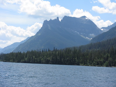
As we descended the headwall via a series of switchbacks we lost considerable elevation from Stoney Indian Pass (6,908 feet) to Atsina Lake (5,765 feet). This beautiful lake is surrounded by Stoney Indian Peaks (9350 feet) to the north, Pyramid Peak (8,170 feet) to the east, Mount Kipp (8,839 feet) to the south, and Cathedral Peak (9,041 feet) to the southwest. One cannot help feeling a little insignificant when surrounded by the extreme geographical relief and knowing the history behind it.
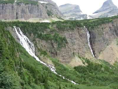
Waterfalls were in no short supply. To the south, water flowing out of 7,145 foot Sue Lake plummeted hundreds of feet as Raven Quiver Falls. We came to the ford across a stream that was located above Atsina Lake that a backcountry ranger had cautioned us about. It was about knee deep and flowing swiftly, but we negotiated it without much trouble. It wasn’t until we had descended further and turned around to look at where we had come from that we saw it. A short distance downstream from where we forded the stream, the water fell, and it fell a long way, about 600 feet. That was Paiota Falls. To the right of Paiota Falls, looking back up the drainage, was the beautiful Atsina Falls. Further down the trail, the Mokowanis Cascade drops several hundred feet.
I find the history of names to be fascinating. Take the names Atsina, Blackfeet, Mokowanis, Belly River, and Gros Ventre for example. American fur traders were the first to use the name Blackfeet to refer to the Niitsitapi. The Haninin were called Gros Ventre by French explorers and Mokowanis, which means ‘big bellies,’ by the Blackfeet. Atsina also refers to the Haninin. It is thought that Atsina, which translates to ‘gut people,’ was also a name given by the Blackfeet.1,3 The Mokowanis River flows into the Belly River which also refers to the Haninin. The stomachs of the Haninin must have been pretty distinctive.
Thomas Blakistan, an English explorer, naturalist, and a member of the Palliser Expedition, named the Belly River in 1858. He knew the meaning of Mokowanis and used the English translation for the river name. The Belly River first appeared on a map in 1865.3
At about 4.5 miles from Stoney Indian Pass, the spur trail to Mokowanis Lake heads south for a little less than one mile to the backcountry campsite by the lake. There is also a campground at the junction, and since the bugs were not bad, we took the opportunity for a little break. We had been seeing a lot of bear scat on the trail, but the campground seemed scat free.
After about one-half mile from the Mokowanis Junction, we passed the campground at the head of Glenns Lake. Another 2.4 miles and we arrived at the campsite at the foot of Glenns Lake which was our destination for the day. We hung our food, set up the tent, and then I headed to the lake for a refreshing dip.
I dove in, and when I came to the surface, there was a bear less than 50 yards from me cruising the shoreline. Luckily the bear was not interested and continued on a path away from me. I continued to watch until it was on the opposite side of the lake and disappeared into the brush.
Lower Glenns Lake to Chief Mountain Trailhead (10.3 miles)
We got an earlier start on our final day. There were three hours of driving to do after reaching the trailhead.
Cosley Lake campground was a short hike at only 1.4 miles from the camp we had left that morning. George B. Grinnell’s map of 1892 shows both Glenns and Cosley Lakes as Lansing Lakes.4 The current name is for the infamous ranger/poacher Joe Cosley.
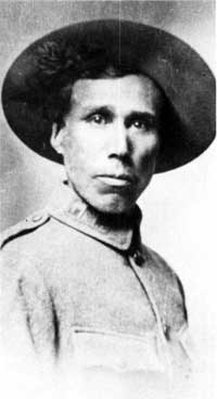
Cosley was one of the first six park rangers hired in 1910 by Major William R. Logan and ended up being the ranger for the Belly River. Even after he had been employed as a ranger in charge of enforcing the laws that governed Glacier National Park, Cosley continued to ply his trade of hunting and trapping. Of course, these were illegal.
Eventually, in the winter of 1928-1929, he was captured at his hunting camp by 24-year-old Joe Heimes. Cosley was taken to Belton where he was charged and tried in the same day. He was given a $100 fine and a suspended jail sentence. Cosley left immediately for his beaver cache in the Belly River. The 59-year-old snowshoed across the continental divide via Ahern Pass in less than 20 hours. He gathered up his pelts and headed into Canada before officials could catch up with him.1
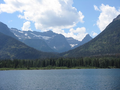
From Stoney Indian Pass, we dropped a little over 2,000 in elevation to arrive at Cosley Lake. Looking back toward where we had come from, the views of Mount Kipp, Pyramid Peak, and Cathedral Peak with the water of Cosley Lake in the foreground are classic Glacier.
Around the foot of this beautiful lake is a trail junction. The trail going to the southeast, the Cosley Cutoff Trail, connects to the Belly River Trail that then joins the Ptarmigan Trail or the Redgap Pass Trail. Both of those routes will take you to Many Glacier. The path leading to the north is the Stoney Indian Pass Trail – the path that we had been following since leaving the Waterton Valley Trail. It connects with the Belly River Trail near the Belly River Ranger Station and then on to the Chief Mountain Trailhead.
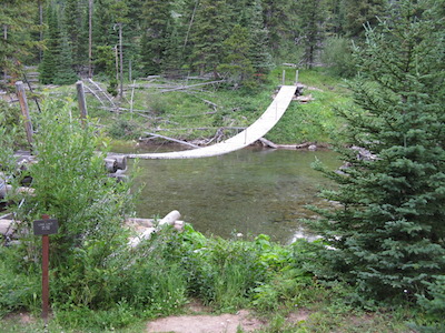
At about three miles from the Cosley Lake campground, the Stoney Indian Pass Trail crosses the Belly River with a suspension bridge just before it joins the Belly River Trail. The Belly Ranger Station can be seen to the southeast. The setting is beautiful. The buildings are set to the far end of a picture-perfect open area with Lee Ridge as a backdrop. This ranger station has never had a road built to it.
The original building was constructed in 1912 but is now used as the barn. It is fun to imagine Joe Cosley taking part in the construction of this square hewn log structure. I’ll bet that building could tell some stories. The current ranger residence was built in 1925 for a cost of $1,500. The woodshed construction followed in 1927 for a fee of $232.75 and the fire cache in 1928 for $450.2
From the ranger station on, we started seeing bear scat again. We never did see a bear nor wildlife for that matter. We are pretty noisy in bear country. So, it makes sense. The final 6.1 miles have minimal elevation gain or loss. Except, and wouldn’t you know it, the trail climbs about 700 feet in the last couple of miles – always more noticeable at the end.
The treat upon reaching the car was a fresh change of clothes. It’s the little things, isn’t it?
End Notes
- Guthrie, C.W. Glacier National Park: The First 100 Years. Farcountry Press, 2008.
- “Montana MPS Belly River Ranger Station Historic District.” National Archives Catalog, Department of the Interior, National Park Service, Sept. 1995, catalog.archives.gov/id/71974902. Accessed 23 July 2018.
- Rayburn, Alan. Stories About Canadian Places. Toronto Press, 2001.
- Robinson, Donald. Through the Years. Glacier Natural History Association, Inc., 1973.

One response to “Goat Haunt to Chief Mountain”
1963 at the beaver dams below Chief Mountain, my friend and I fished daily. I regret not remembering my fishing partners first name. I believe his last name was Fredricks. We had a life time of fun that summer. At the age of 13 or 14 we had no worries. State of Montana had hired Fredrick Construction Company out of Billings to rebuild and resurface the highway going to Canada on east edge of Glacier Park.. This is all from memory so may not have names correct. Fredrick may have been the road boss. Each day we would hitch a ride from Babb to the constrction site, and return to the highway in the afternoon. With a kell of pan sized trout. I remember walking a 2 track trail to the dams, passing by a sheep herders camp wagon, jeep parked beside it, only seen the man a couple times. He must have been with the sheep . If by chance the other boy would read this my name is larry G, Scobey Montana.
LikeLiked by 1 person