
The Apgar Fire Lookout perches on an overlook in the Apgar Mountains southwest of Lake McDonald. Put this on your list for early season hikes or if in summer the first half of the day. The 2003 Robert Fire removed the lodgepole pine forest, and the trail on the southwest slope can get toasty. However, beautiful vistas await as anyone who has been there or viewed the webcams can attest.
The namesake for all of this was Milo B. Apgar. He settled at the foot of Lake McDonald in the 1890s. It didn’t take him long to realize that the Great Northern Railway would bring visitors to this rugged and remote location and they would need a place to stay and food to eat. He built cabins for them near the lake and McDonald Creek.² The Village Inn at Apgar occupies the site now.
Trailhead
Drive 0.3-miles past the West Entrance and turn left toward the Glacier Institute. At the T-intersection turn right. Soon after, turn left and drive past the Swan Outfitters Corral. From the Quarter Circle Bridge over McDonald Creek, travel 1.5 miles to the trailhead.
Difficulty
The hike is 7.2 miles (11.6 km) round trip with a 1,850-foot (564 meters) elevation gain. The lookout sits at 5,236 feet (1,596 meters).
The difficulty rating of this hike varies with the source. For example, the Sierra Club Hike Rating Scale pegs this as moderate difficulty. The NW Hiker Calculator gives a score of 18, which they consider challenging. There are other variables to consider. Although not an exhaustive list, trail condition, weather, the physical condition and age of the hiker, and the load carried are essential considerations.
A difficulty rating system conceived by Paul Petzoldt, an accomplished mountaineer and founder of the National Outdoor Leadership School (NOLS), makes the most sense to me. He bases the unit of measure for the calculation on the energy needed to walk one level mile – an energy mile. So, total distance gives you the energy miles to start with. Then add two energy miles for every 1,000 feet of elevation climbed.
The total distance for the lookout climb is 7.2 miles or 7.2 energy miles. The elevation gain requires an additional 3.7 energy miles. The sum is 10.9. A score less than 5 suggests an easy hike, 5 – 10 moderate, and greater than 10 strenuous.
Research in the Exercise Physiology Laboratory at Western Carolina University discovered Petzoldt wasn’t that far off.³ The system is not perfect, but it gives one a means to compare the relative difficulty of hikes.
The Hike
Water will not be available after you leave the lower portion of this trip. So, be sure to bring plenty. And, carry your bear spray where it is quickly accessible. Know how and when to use it.
Be aware that Glacier National Park has rules concerning pets in the park. It’s a good idea to be familiar with these park policies. You don’t want your fun money going to pay a hefty fine.
The trail leaves the parking lot in a northwest direction under the crowns of lodgepole pine and western larch. These trees probably sprouted after the 103,000-acre 1929 Half Moon Fire consumed the previous forest.
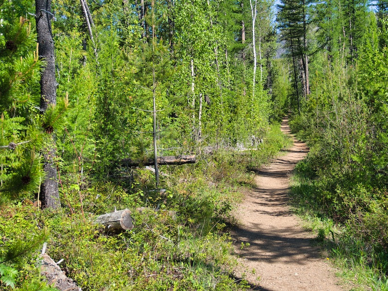
Several clues point to the character of the pre-fire forest. For example, thimbleberry, bead lily, fairy-bells, starry false Solomon’s-seal, growing under the lodgepole pine canopy, prefer moist, shady forest sites. Healthy western redcedar has become prominent in the understory. They too prefer wet, shaded places. Both lodgepole and western larch are intolerant of shade. So, left undisturbed, the cedar will be more successful at regeneration. Before the 1929 fire, this was probably a western redcedar, western hemlock forest similar to what we see in the Lake McDonald Valley.


Bears come to feed on the grasses, sedges, and dandelions in the moist areas. Later they take advantage of the berry crop produced here.
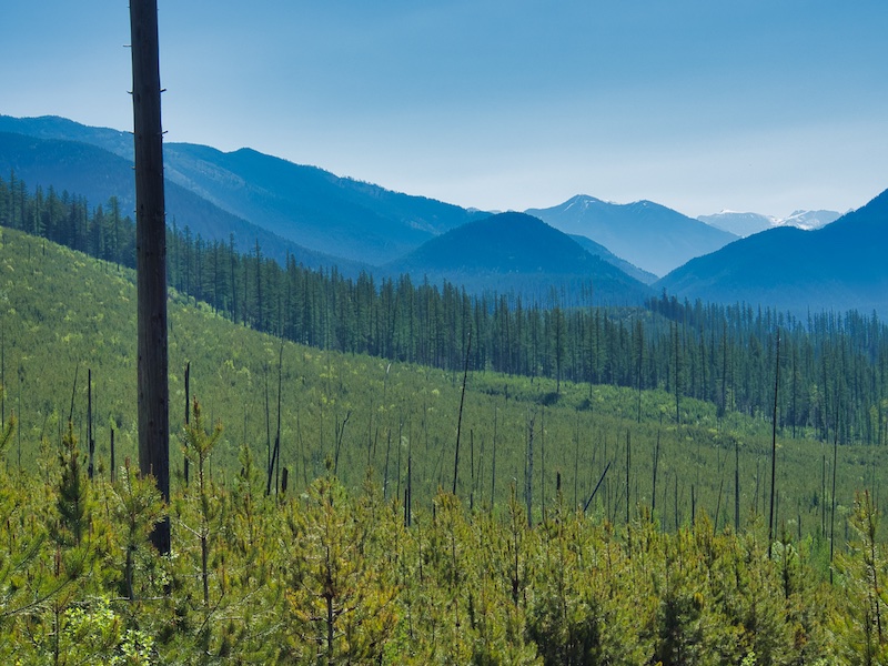
It doesn’t take long to emerge from this 90-100-year-old stand of trees and enter a sea of short “doghair” lodgepole pine. This fire-adapted species came through again and started the healing process after the 2003 Robert Fire. That summer, there were 26 wildfires in the park burning 13 percent of its area.
Ceanothus or buckbrush is a fragrant evergreen shrub you will see along the trail. This is a remarkable plant. Its seeds can survive in the soil for centuries waiting for a fire to start their germination process. But that’s not all. Ceonothus, together with bacteria that live in little nodules in their roots, take nitrogen from the air and convert it to a form that the plant can use. As they colonize a post-fire area, the shrubs also help improve the soil. Look for their tiny white flowers starting in June and into July.

The trail makes three long switchbacks as it climbs a southwest slope of the Apgar Mountains. I was on this trail before the 2003 fire when trees provided shade. Not so today. This can be a toasty hike during warm summer afternoons.

When you see an outhouse and a hitching rail, you’re close to your destination. There is a short trail to the right where the lookout comes into view.

At the Lookout
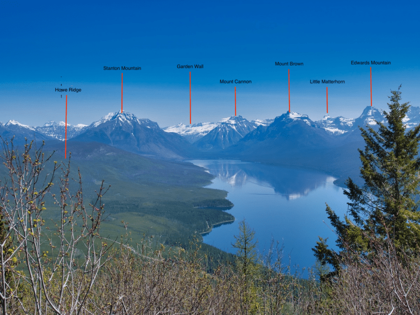
As you face Lake McDonald 2,000 feet (610 meters) below, Howe Ridge is to the left. At the end of Howe is Stanton Mountain, followed by Mount Vaught. The Garden Wall is at the far end of the valley. Snyder Ridge is on the right side of Lake McDonald. The first peak above the valley on that side is Mount Brown with Mount Cannon further to the northeast. Edwards Mountain is just east of Mount Brown, and the Little Matterhorn rises between the two. The spectacular spire of Mount Saint Nicholas stands proud to the southeast about 24 miles (39 kilometers) away.
The National Park Service initially built the Apgar Lookout in 1929. Within two weeks of completion, the Half Moon Fire destroyed it. The Park Service rebuilt the structure you see today in 1930. It’s on the National Register of Historic Places.¹
Notes
1. “Apgar Fire Lookout.” National Register of Historic Places, National Park Service. Accessed May 2, 2019. https://npgallery.nps.gov/NRHP/GetAsset/1e5a2539-a0ec-4eac-a9d6-987509d132db.
2. Guthrie, C.W. The First 100 Years. Helena, MT: Farcountry Press, 2008.
3. Holcombe, Randall. “‘Energy Mile’ Theory Tested in Laboratory.” Western Carolina University. Last modified May 10, 2011.
