
Over 100 years ago, guests staying at the former Going-to-the-Sun Chalets on Saint Mary Lake delighted in a hike to three beautiful waterfalls.1 Early in the season, my wife and I retraced the footsteps of those early visitors who invested considerable time and money to visit this incredibly beautiful place in the newly created Glacier National Park.
Trailhead
This hike begins at the renovated Sun Point picnic area, trailhead, and shuttle stop. From the west entrance to the park, it is 40 miles up and over Logan Pass on the Going-to-the-Sun Road. The drive is only 10 miles from the east entrance.
As you stand in the picnic area facing the restroom facilities, the sidewalk to the right will lead you down to the Sun Point Nature Trail. Walk down this trail a short distance, and there will be a junction. Go left to reach Sun Point.
There is another way to Sun Point which is the path that we followed. The sidewalk going to the left of the restroom will intersect with a trail that will lead you up the east side of the rocky bluff that juts into Saint Mary Lake. This is Sun Point.
Before you hit the trail, be sure that you have your bear-spray where you can access it quickly.
Going-to-the-Sun Chalets
The rock perch 100 feet above the surface of Saint Mary Lake was the location chosen for the Swiss-style chalets which were constructed during the years 1912 to 1915. Sun Camp, the informal name for the complex, accommodated 200 guests. These adventurers could only reach this impressive place by boat or packhorse. It was expensive and took a considerable amount of time to get there.1

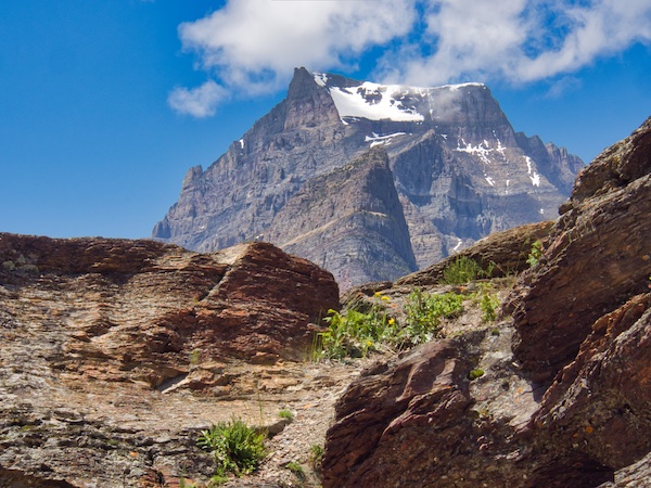
The panorama to the west of Sun Point has never become commonplace for me. I am filled with awe when viewing the sheer rock faces of the three glacially carved mountains, Mahtotopa, Little Chief, and Dusty Star. These three massive peaks seem to be on a collision course with the pristine waters of the lake. In the distance, to the west, is the spire of Fusillade Mountain with a long thin silver ribbon to its north which is Florence Falls. To the northwest and monopolizing the skyline is Going-to-the-Sun Mountain.
Fusillade Mountain: Named by George Bird Grinnell in 1891 as a satirical gesture at W.H. Seward and Henry L. Stimson for firing a futile volley at a group of goats on the side of this mountain.2
After the Going-to-the-Sun Road was dedicated in 1933, Sun Camp slowly began to lose business much to the surprise of those who predicted just the opposite. The perceived value connected to the difficulty reaching such a magnificent and isolated place had dwindled. During World War II the buildings fell into disrepair and were finally razed in 1948.1
The Hike
The total distance from Sun Point to Virginia Falls is 3.2 miles. If you don’t feel like making the entire return trip, there are three spur trails along the way that will allow you to access the Going-to-the-Sun Road and shuttle stops. From these locations, you can catch a free ride back to your vehicle. Be sure to make a note of these junctions as you pass them.
There is also the option of arranging for a boat ride from the Glacier Park Boat Company dock near Baring Falls to the Rising Sun dock and then using the free shuttles to get back to Sun Point. Finishing a great hike with a cruise on the historic 45-foot Little Chief built in 1926 would be a treat.
From Sun Point, walk west. This will put you on a nearly level path which follows the north shore of Saint Mary Lake for a while. At almost 10 miles long and 300 feet deep, this is the second largest body of water in Glacier National Park. Surprisingly, it is 1,500 feet higher in elevation than the largest lake in the park, Lake McDonald.
St. Mary Lake and Lower St. Mary Lake have had more than one name. The Piegan Indians called these lakes the “Walled-in Lakes,” while the Kootenais called them “Old Woman Lakes.”2
After only 0.8 miles, Baring Falls is the first of the three gems that you will experience. The bridge downstream from the falls offers photo opportunities, and there is also a short path that will give you different vantage points closer to the falls. Use caution around the wet rocks.
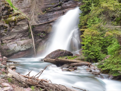
After leaving Baring Falls, a stroll of 1.6 miles will put you at Saint Mary Falls. Along the way, you will get to witness the regeneration of the forest that is happening following the 4,458-acre Reynolds Creek Fire of 2015. It didn’t take long for the next generation of trees and wildflowers to introduce themselves.

You will probably hear the cascades before you see them. There is a bridge that crosses the Saint Mary River just below the falls. This very accessible location can get crowded, but there is a small area on the far side of the bridge where you may be able to enjoy a snack and snap a few pictures. If it’s a hot day, the cold rush of air and the mist from the thundering water is a bonus.

Fewer people continue on to Virginia Falls. However, these spectacular waterfalls are only 0.8 miles beyond Saint Mary Falls, but it does include a climb of 285 feet in elevation. This short trail section is also part of the Continental Divide Trail.
As you approach the falls, you will come to a trail junction. Going to the left will keep you on the Continental Divide Trail. Take the right fork for a short distance to get up close and personal with the falls. Be very careful because the rocks can be extremely slick. More injuries and deaths in Glacier National Park are associated with water and the adjacent slippery stones than any other cause.

The hikers of the early 1900s had the Sun Camp dining room waiting for them at the end of the day. Even though it won’t be there for you, Two Dog Flats Grill at Rising Sun, just down the road from the Sun Point turn-off, offers casual fare and refreshing beverages.
Glacier National Park Guidebooks
Don’t just visit Glacier, experience it! This guide provides all the essential information you need for a seamless and enjoyable trip across the world-class Going-to-the-Sun Road. From lodging and dining to hiking trails, scenic viewpoints, and more, this guide has you covered. Order now and start planning your adventure
A Local’s Hiking and Planning Guide for Eastern Glacier: Don’t let the park’s vastness overwhelm you. Our comprehensive ebook is your key to unlocking over 50 hikes through Glacier goodness. A one-time purchase, a lifetime of memories.
End Notes
- “Going-to-the-Sun Chalets.” National Park Lodge Architecture Society, National Park Lodge Architecture Society, 2009, http://www.nplas.org/goingtothesun.html. Accessed 20 Aug. 2018.
- Robinson, Donald H. Through the Years. 5th ed.: Glacier Natural History Association, Inc., 1973.
