
This trail leads to the site of a historic ranger station, offers a display of nature’s recovery from two major wildfires and a little solitude. It’s a good early season choice for hikers and bikers alike.
Trailhead
From the park’s west entrance, drive 0.3 miles. When you see the sign for the Apgar Lookout, turn left. Continue 0.3 miles to a T-intersection and turn right. Drive past the Quarter Circle Bridge for 0.8 miles to the small trailhead parking lot marked with a sign that is also small.
Hike Summary
| Total Distance: 6.9 miles |
| Total Elevation Gain: 322 feet; Loss: 379 feet |
| Difficulty: 7.5, moderate (based on Petzoldt’s energy-rated miles) |
| Estimated Walking Time: 3 hours 5 minutes (Calculated using an average moving speed of 2.5 mph and Naismith’s correction for elevation gain.) |
The Hike
After the razing of the station buildings in 1966, the Park Service abandoned its 1940s road to the Flathead Ranger Station. The roadway returned to the forest. After 50 years, the old road has morphed into this trail, which is one of only three bicycle-friendly paths in the park.
The footpath will lead you through recently burned forest (2003 Robert Fire, 53,000 acres) and land that was burned almost a century ago (1929 Half Moon Fire, 103,00 acres). Both of these fires were human-caused.

The Halfmoon Fire started near Columbia Falls and raced eastward, jumping the Middle Fork of the Flathead River, burning over Belton (West Glacier), Apgar Flats with its cedar-hemlock forest and on to Nyack and Harrison Lake.1 The Robert Fire threatened West Glacier and Apgar, which were evacuated twice. Firefighters set backfires that redirected the path of the huge fast-moving inferno. This action saved both villages.2
Despite the destructive force of these fires, the landscape is now a testament to nature’s remarkable ability to heal. Rebirth and recovery are all around. As you walk, notice the thick stands of 20 foot tall lodgepole pines, a species adapted to fire. Their serotinous cones, which require heat to release their seeds, are a testament to this adaptation. This strategy capitalizes on the post-fire conditions of bare soil and reduced competition. But only when the trees are older than 30 years will they produce this type of cone. In contrast, non-serotinous cones release seeds without fire. Trees produce this type as early as 5 to 10 years, ensuring the species’ survival even in the absence of fire.4
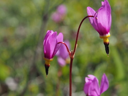
Along the footpath, beginning in April, blue violets and glacier lilies mark the start of the color season, with arrow leaf balsamroot, shooting stars, and blue clematis arriving in May. Heart-leaf arnica and lupine start showing off in June and paintbrush in July.

At 3.4 miles, you’ll arrive at the site of the once-bustling ranger station. Walk south a short distance through the trees to view the Middle Fork of the Flathead River. Continue on the trail another 500 feet to an overlook of the North Fork of the Flathead River. Soon after this point, the trail becomes overgrown.
Historical records show that the area’s easy access from the west made it a point of concern for park officials in the early days. The park also surrounded some pre-existing private property. Poaching was a problem.3
To address the poaching issue in the southwest region of the park, park officials established the Flathead Ranger Station in the early to mid-1920s. By the late 1920s, park officials staffed the station year-round. On August 17, 1929, the Half Moon Fire started outside the park, hopped the river and destroyed the ranger station. Congress approved funding in 1930 for four new structures: a residence, barn, fire-cache, and woodshed.3
The 1940s saw the construction of a road providing direct access to the compound from Belton (West Glacier). Automobile use meant the ranger station only needed intermittent staffing. The buildings deteriorated. Glacier National Park employees finally removed the residence, barn, and woodshed in 1966, leaving the fire-cache and an outhouse.3 Today, nature has left no evidence of structures. I assume the Robert Fire was responsible.
Notes
- “Fire History.” Glacier National Park. Last modified November 13, 2024. https://www.nps.gov/glac/learn/nature/fire-history.htm.
- Franz, Justin. “Glacier’s Big Burn.” Flathead Beacon, August 14, 2013. https://flatheadbeacon.com/2013/08/14/glaciers-big-burn/.
- Hufstetler, Mark. Glacier Historic Structures: Narrative Histories Report. N.p.: Glacier National Park, 1988, 194-196.
- Lotan, James E., and David A. Perry. Ecology and Regeneration of Lodgepole Pine. N.p.: USDA Forest Service, 1983. https://babel.hathitrust.org/cgi/pt?id=uva.x030492876&seq=1.
