
This beautiful hike is in the scenic Two Medicine Region of the southeast part of Glacier National Park.
Trailhead
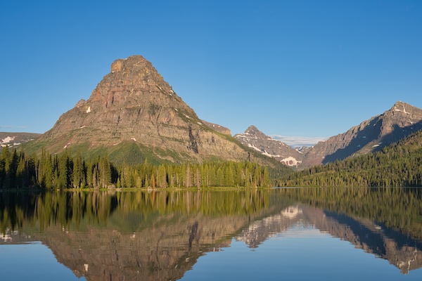
The hike begins south of the parking lot near the Two Medicine Camp Store. Head south past the boat dock for a short distance to find the South Shore Trail. This path will lead to the Two Medicine Pass Trail and eventually to Cobalt Lake. I’ve included four side trips for you to consider—three of which are pretty easy, and one that’s a bit more challenging.
Hike Summary
| Total Distance: 11.6 miles |
| Total Elevation Gain: 1,578 feet; Loss: 152 feet |
| Difficulty: 14.8, strenuous (Calculated using Petzoldt’s Energy Rated Mile equation.) |
| Walking Time: 5 hours 26 minutes (Calculated using an average moving speed of 2.5 mph and Naismith’s correction for elevation gain.) |
The Hike
The first 2.4 miles of the South Shore Trail can get pretty busy, especially from late morning through the afternoon during July and August. You might think that bears would avoid such a busy area, but that’s not always the case. On my last hike to Cobalt, a bear crossed the trail within a mile of the Two Medicine Camp Store in the early afternoon, even with scads of people on the footpath. It’s wise to be familiar with bear safety protocols before you head out.
Thimbleberry and huckleberry shrubs line the footpath in the first part of the hike. The raspberry-like thimbleberry and purple fruits of the huckleberry ripen from late July into August. Being able to snack on these tasty fruits while hiking is an enjoyable part of the Glacier experience, but remember that these berries are a crucial food source for our local bears. Check with park staff for the latest regulations on picking larger quantities. Also, keep an eye out for Fool’s huckleberry, which is common along the trail and not good to eat. If you crush a leaf from the shrub and it smells skunky, you don’t want it.
Paradise Point Option
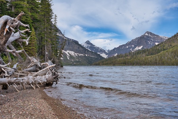
Just a quarter of a mile from the trailhead, you’ll come to a junction for a spur trail leading to the shore of Two Medicine Lake. This quick side trip offers outstanding views of Lone Walker Mountain and Mount Helen to the west and Rising Wolf Mountain to the north. It will add 0.8 miles to your hike. If you like to fish, this can be a productive site.
After the Paradise Point junction, the South Shore Trail wraps around some beaver ponds. These small bodies of water are likely spots to see moose, so keep your eyes peeled.
Aster Falls Option
At 1.2 miles from the trailhead, you’ll reach the path for Aster Falls on your left. This out-and-back trip adds only 0.3 miles and is worth a look early in the season.
One mile from the Aster Falls junction, or 2.2 miles from the trailhead, you’ll cross Paradise Creek via a suspension bridge. If you’ve never used one of these bridges, it can be a fun experience. A short distance after this, the South Shore Trail meets the Two Medicine Pass Trail. If you turn right here, 1.3 miles later, you will come to the west shore boat dock for the historic vessel Sinopah. Narrated trips aboard the Sinopah can be entertaining. If that interests you, consider buying return tickets for the Sinopah before starting your hike.
To continue to Cobalt Lake, turn left onto the Two Medicine Pass Trail.
Rockwell Falls Option
At 3.3 miles, you’ll cross a creek flowing with water from Cobalt Lake. Just 100 feet upstream is a beautiful view of lower Rockwell Falls, the perfect place to beat the heat on hot days.

After crossing the creek, the trail gains elevation using several switchbacks to reach the subalpine glacial valley that holds the 11-acre Cobalt Lake. The views get more spectacular as you climb. At 5.5 miles from the trailhead, you’ll find the junction for the spur trail to the lake. The shoreline is a short walk from there.
You’ll get the best views from the southeast shore. Cross the creek using the large flat rocks and continue past the backcountry campground food prep area. Along the way, you’ll notice several “social” trails headed for the lake with obvious obstacles and signs placed to discourage folks from using them. Please do so. The trail meant to be used is just after the food prep area. Once at the lake shore, work your way through the stunted trees and over the talus field to be rewarded with stunning views of Mount Rockwell and the ridge connected to Sinopah Mountain.
Chief Lodgepole Peak Option
This is the more strenuous side trip, which adds 4.2 miles and 1,156 feet of elevation gain to your hike. Head back to the junction for the lake, turn left, and climb for 2.1 trail miles to reach the 7,682-foot summit. I’ve seen bighorn sheep on this section in the past. The views from the top are photo worthy.
A final note. We’ve all heard the advice to bring plenty of water and food on a hike. If you’re just getting started in the outstanding outdoor activity of hiking, the word plenty may be too vague. Following are some general rules of thumb that can provide some clarity.
- Drink about 0.5 liters per hour on an outing. Age, weight, physical condition, temperature, difficulty of a hike and altitude will affect that number.1 If you have a water purification system, it will eliminate carrying a lot of water weight.
- Consume quality calories. Carbohydrates are the body’s primary fuel source during exertion. I try to avoid simple sugars because they work against my endurance. Complex carbohydrates are better. In addition, include some protein on extended hikes like this one to Cobalt Lake.
- Consume enough calories. General guidelines suggest eating 200 – 300 calories per hour. A 130 pound person would need closer to the 200 calorie amount, while a 200 pounder would need around 300 calories per hour.2 Your physical condition, the hike difficulty, and weather can affect these numbers, but they are a starting place.
I’d like to learn if you found this post helpful—what you liked and even what you didn’t like. Please let me know in the comments. Happy hiking!
Glacier National Park Guidebooks
Your Ultimate Guide to Going-to-the-Sun Road: Invest in your adventure and unlock the full potential of this iconic road. For the price of a movie, a lifetime of memories.
A Hiker’s Companion: For a small price, you can unlock countless hours of exploration. Start exploring!
Notes
- “Dehydration.” Cleveland Clinic. 2019. https://my.clevelandclinic.org/health/treatments/9013-dehydration.
- “Hill Walking Calorie Estimator.” Last modified April 30, 2019. https://jscalc.io/calc/yFvvpeAfQ9lPBnGU.
