
McDonald Creek Trail is a multi-season route through a cedar-hemlock forest. The trail is snow free in spring long before the high country opens up. Shade and the cooling effect of flowing water make the walk attractive during the heat of summer. Cool, moist fall days create wonderful earthy smells and bring forth all kinds of mushrooms of different colors and shapes. Winter creates a special beauty here. Consider strapping on snowshoes to experience it.
Trailhead
The walk begins near the north end of Lake McDonald. Turn left onto North McDonald Road 1.3 miles east of Lake McDonald Lodge along the Going-to-the-Sun Road. Cross the bridge over McDonald Creek and continue for 400 feet. You’ll find small pull outs for parking near the trailhead sign.

The largest lake and longest creek in the park, the 1913 Swiss-chalet style lodge, waterfalls, and a road all ended up with the name McDonald attached to them. But it wasn’t always so.
The lake and stream have had several names. Among them were Lac de Poissons, Lake Terry, Goat Creek, Gibbons River, The Bear Wags Its Tail (from the Blackfeet), and The Place Where They Dance (from the Kootenai).1,8 Visitors knew the lodge as Lewis Hotel until 1957.3,7
The moniker that stuck comes to us from the son of Angus McDonald, a Hudson Bay Company chief trader. In 1878, Duncan McDonald was on a journey to Canada with a small group guided by the Kootenai chief, Aeneas. They camped at the traditional Kootenai wintering grounds near present day Apgar, known as The Place Where They Dance. Duncan carved his name and date on a nearby tree. Later, witnesses of Duncan’s handiwork assigned his name to the adjacent body of water and it somehow stuck.1,7,8
The Hike
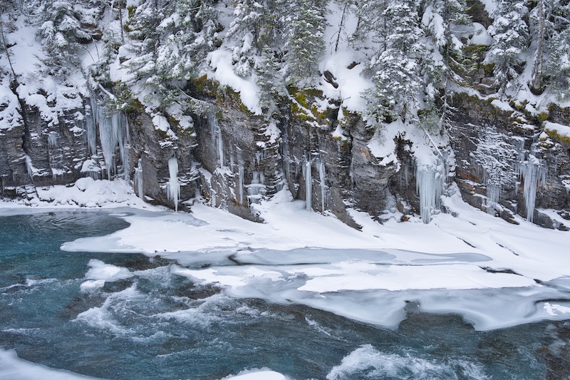
McDonald Falls is about a half mile into the hike. In spring, it’s a turbulent and roaring torrent and in winter a mass of aquamarine-colored ice. The resistant rock over which the water crashes is of the Prichard Formation—1.4 billion years old and the most ancient on the west side of the park.6

To put that age into perspective, one would need to count 24 hours per day every day without stopping for a little over 33 years to reach 1.4 billion. Land plants don’t show up in the fossil record for another 900 million years.
At three-quarters of a mile, the trail comes to Sacred Dancing Cascades and the foot-bridge over McDonald Creek. The ledges of rock over which the water tumbles are also from the Prichard. Crossing the creek and continuing on the path leads to a parking lot on the Going-to-the-Sun Road and the Johns Lake Loop Trail. Continue straight away for this hike.
Not long after leaving the bridge, barriers and signs caution passersby that the section of McDonald Creek below is an important harlequin duck habitat. The signs ask folks not to disturb the birds.
Twenty-five percent of all harlequin chicks born in Montana hatch in the McDonald Creek drainage. The population trend for this colorful bird species is on the decline in the western United States. But Glacier National Park birds seem to buck that trend. Their numbers have remained stable.2
Females return from the west coast each year only to the stream of their birth. Further, they only have one shot per season at raising chicks. The year is a bust if flood waters destroy their stream-side nests or people frighten her away.2 They could use our cooperation.

About 1.5 miles from the trailhead, the path comes to an old oxbow next to McDonald Creek. Here, the footpath moves away from the creek and then returns after a mile. Within this section, depending on the season, the trail either disappears into a dry-cobbled creek bed 100 feet wide or ice-cold water of the same width. Over one thousand feet above, a cirque lies between Stanton Mountain and Mount Vaught. This mile and half wide bowl provides significant snow meltwater to this seasonal stream. If you plan on visiting during spring runoff, bring your water shoes.
Massive and expansive mountains of the Continental Divide separate the Pacific Maritime Climate from the influence of the severe Arctic Continental Climate to the east. The Lake McDonald area is an easternmost finger of that northwest weather system, which brings heavy moisture and moderate temperatures. It’s also the eastern limit of cedar-hemlock forests. The trail continues under these trees where lush green moss monopolizes the forest floor.
Where the hike approaches the turnaround point at just under 2.7 miles, the path provides a great vantage point above McDonald Creek and the water squeezing through angular rock formations. When walking over the scoured cliff tops, notice the many cylindrical potholes. During times of high volume turbulent flow, swirling eddies used gravel and grit to bore into the solid stone. Witnessing that much water and the accompanying force would be unforgettable.
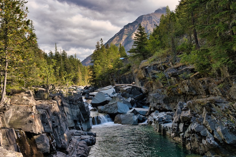
This is a great place to soak up some rays and have a bite to eat before starting back.
Option
Want to switch it up on the return trip? Instead of backtracking to the North McDonald Creek Road, take the Johns Lake Loop Trail when you reach Sacred Dancing Cascade. The detour is only about three-quarters of a mile farther and includes a charming little lake.
Cross over the bridge below Sacred Dancing Cascades and follow the trail up to the Going-to-the-Sun Road. On the far side of the blacktop, look for a trail entering the forest. That’s your path back. You’ll encounter three trail junctions along the way. The map above should help you visualize the route.
Hike Summary
| Total Distance: 5.3 miles |
| Total Elevation Gain: 207 feet; Loss: 61 feet |
| Difficulty: 5.7, moderate (Calculated using Petzoldt’s Energy Rated Mile equation.) |
| Estimated Walking Time: 2 hours 23 minutes (Calculated using an average speed of 2.5 mph and Naismith’s correction for elevation gain.) |
Glacier National Park Guidebooks
Maximize Your Adventure: Learn about the diverse recreational opportunities available along the Going-to-the-Sun Road, including hiking, biking, boating, and more. A small price to pay for endless outdoor experiences.
From Novice to Expert, We’ve Got You Covered: For the price of a huckleberry shake, you’ll have everything you need to plan and execute your adventure in Glacier National Park’s east side.
Notes
- “Glacier’s Names: A history of the park told in titles and legends.” Hungry Horse News, ca. 1983.
- “Harlequin Ducks Resource Brief: Glacier National Park.” National Park Service. Accessed November 15, 2018. https://www.nps.gov/articles/harlequin-ducks.htm.
- “Lake McDonald Lodge.” National Register of Historic Places. https://npgallery.nps.gov/nrhp.
- “Leave No Trace.” Leave No Trace Center for Outdoor Ethics. https://lnt.org/learn/7-principles.
- “Mosses and Liverworts.” Glacier National Park Montana. Last modified May 22, 2016. https://www.nps.gov/glac/learn/nature/mossesandliverworts.htm.
- Raup, Omer B., Robert L. Earhart, James W. Whipple, and Paul E. Carrara. Geology Along Going-to-the-Sun Road Glacier National Park, Montana. West Glacier, MT: Glacier Natural History Association, 1983.
- Robinson, Donald H. Through the Years: in Glacier National Park. 5th ed. West Glacier, MT: Glacier Natural History Association, Inc., 1973.
- Thompson, Sally. People Before the Park. Helena, MT: Montana Historical Society Press, 2015.
