
The Pacific Northwest weather has left its mark on the beautiful Lake McDonald Valley. Here, you can find ancient western redcedar and western hemlock trees, growing at the eastern edge of their range. Below the dense forest canopy, ferns, moss, liverworts, and mushrooms are reminiscent of a temperate coastal rainforest. This area of the park is one-of-a-kind.
Johns Lake Loop features the placid little pond where carnivorous plants secretly go about their business and locations where McDonald Creek crashes over staircases of ancient rock. Near the end, stand above McDonald Creek while watching it become part of Lake McDonald, an idyllic scene at sunset.
Trailhead
The hike begins from the Going-to-the-Sun Road 1.3 miles northeast of the entrance to Lake McDonald Lodge. Look for a small roadside parking area on the right with the Johns Lake Trailhead sign. The loop described below begins here and progresses counter clockwise.
If the trailhead parking lot is full, there are a couple of options:
- Drive 0.8 miles farther to the Sacred Dancing Cascades parking lot on the left. You can begin the loop hike there.
- Across the Going-to-the-Sun Road from the Johns Lake parking area is the North McDonald Road. Turn left there and you will see parking on your left. If that doesn’t work out, continue over the McDonald Creek bridge. The sign for the McDonald Creek Trail is about 400 feet beyond the bridge. There are small pullouts for parking. (The lower part of the McDonald Creek Trail is also part of the Johns Lake Loop.)

The Hike
The trail climbs to intersect the footpath to Avalanche Campground, which is a little over four miles away. Turn left. After a short distance, the McDonald Creek Cutoff Trail (horse trail) peels away to the left. Bear right to stay on the Avalanche Campground Trail and Johns Lake. Begin looking for the lake on your left about a half mile from the trailhead. A couple of paths lead down to the water’s edge.
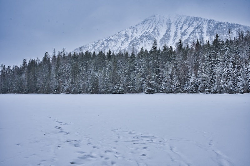
Johns Lake is a tranquil five acre body of water. In winter, it’s encased in a sheet of ice and during summer, lily pads decorate its surface. On a calm day, Stanton Mountain’s reflection on a glass-like surface is photograph-worthy.
The lake is nutrient poor because not much water flows through it. Sphagnum moss finds these conditions adequate. Like its family member the blueberries, it secretes acid into the water to lessen competition from other plants. Two particular plants don’t seem to mind the acidic environment.3
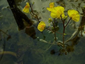
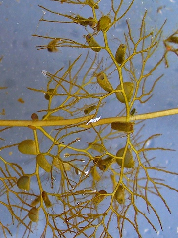
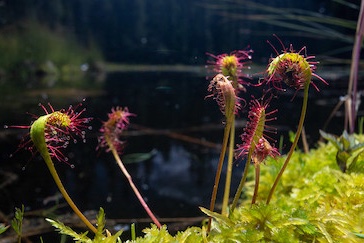
Mountain bladderwort and sundew grow on the surface of sphagnum. Like other plants, they produce food by photosynthesis, but they get most of their essential nutrients, like phosphorus and nitrogen, by feeding on tiny insects. They’re carnivores.
Mountain bladderwort has no roots, but has leaves and specialized branches that produce semi-inflated bladders. When an insect touches a trigger hair near one of these sacs, there is an instantaneous inflation, which pulls the insect inside. Digestive enzymes then go to work separating the nutrients from the unfortunate prey.3
Reddish-purple gland-tipped hairs cover the sundew leaves. Insects attracted to the glistening little drops of liquid at each hair’s end find themselves stuck with the slightest contact. When they struggle, the leaf curls around them, pressing the glands with digestive enzymes against their body.1
When you return to the main path, Johns Lake Trail splits to the left and begins its descent to the Going-to-the-Sun Road. The Avalanche Trail continues to the right. At the asphalt, you’ll see the Sacred Dancing Cascades parking lot across the road.
The Johns Lake Trail continues from the southwest end of the parking area and descends to the footbridge across McDonald Creek. Just upstream from the bridge are the Sacred Dancing Cascades. One day is not enough to know a person. Likewise, for these waterfalls. During the height of spring run-off, you feel the power of the roaring whitewater in your bones. If you visit during a scorching hot August, the cool, tumbling water provides a welcome respite from the heat. In January, the frigid water seems to withdraw into itself behind a white coating of frozen mist.

When you’re ready to leave the cascades behind, turn left on the far side of the bridge to visit McDonald Falls about 0.4 miles away. Continue to bear left when the trail splits.
Both Sacred Dancing Cascades and McDonald Falls exist because of the erosion resistant rock of the Prichard Formation—1.4 billion-year-old stone and the most ancient on the west side of the park.2 Then, the Earth spun faster, only taking 18 hours to rotate once on its axis instead of 24.
The fossil record shows that when the Prichard was still mucky sediment under the ancient Belt Sea, aquatic single-celled organisms were the predominant life forms on our planet. It took another 900 million years for land plants and aquatic vertebrates to show up.
Through the seasons, McDonald Falls has much the same traits as the Sacred Dancing Cascades, minus the tumbling part. I’ve just never seen that. It’s just keeps crashing and pounding.

North McDonald Road is 0.4 miles from McDonald Falls. When you reach the blacktop, it’s only 0.3 miles back to the starting point. Turn left for the McDonald Creek Bridge and a view of Lake McDonald, which occupies a glacially carved 472-foot depression.2 After passing a gated road, you’ll soon find Johns Lake Loop Trail continuing on the right side of the North McDonald Road.
Hike Summary
| Distance: 2.0 miles |
| Total Elevation Gain: 221 feet; Loss: 224 feet |
| Difficulty*: 2.4, easy (Calculated using Petzoldt’s Energy Rated Mile equation.) |
| Estimated Total Walking Time: 55 minutes (Calculated using an average speed of 2.5 mph and Naismith’s correction for elevation gain.) |
Notes
- Fitzpatrick Kimball, Shannon, and Peter Lesica. Wildflowers of Glacier National Park. Kalispell, MT: Trilliumn Press, 2010.
- Raup, Omer B., Robert L. Earhart, James W. Whipple, and Paul E. Carrara. Geology Along Going-to-the-Sun Road Glacier National Park, Montana. West Glacier, MT: Glacier Natural History Association, 1983.
- “Wetlands, Marshes and Swamps.” Glacier National Park Montana. Last modified November 14, 2016. https://www.nps.gov/glac/learn/nature/wetlands.htm.
