
Trailhead
Visit both Paradise Point and Aster Park via the South Shore Trail. The path begins about 150 feet south of the boat dock near the Two Medicine Store. Paradise Point is a brief side trip and only adds about 0.8 miles and around 20 minutes to the Aster Park hike.
Hike
The footpath meanders through a lodgepole pine and subalpine fir forest. Fire-resistant beargrass is abundant. A common myth claims this member of the lily family only blooms once every seven years. However, it’s precipitation and soil moisture that makes the call.2 If the conditions are just right, the blossoms seem to me like hundreds of long, pure-white puffs of smoke hanging a couple of feet above the forest floor.
At 0.2 miles from the trailhead, the Paradise Point Trail leaves the South Shore Trail and heads for the lake. Spectacular views await at the water’s edge. And, if you’re so inclined, there are fish to be caught.
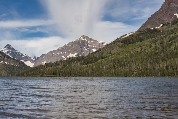
From the gravel beach, the massive Rising Wolf Mountain fills the view to the north. Other peaks, in order going counterclockwise, are Mount Helen, followed by Lone Walker Mountain. The ridge on the far left belongs to Sinopah Mountain. Except for Mount Helen, the names of the peaks above all belonged to people who were family. Lone Walker was a Blackfeet Chief and the father of Sinopah. Rising Wolf, the name given to the Hudson’s Bay trapper Hugh Monroe by the Blackfeet, was the husband of Sinopah.5
After leaving Paradise Point and rejoining the South Shore Trail, one enters an area of beaver ponds after 0.2 miles. This marshy area is also excellent moose habitat.
The antlered beasts found in Glacier National Park are of the Shiras subspecies, the smallest body moose in North America. Bulls average 800 to 1200 pounds, and cows 600 to 800 pounds. An enormous animal, to be sure. Contrast that with the Alaskan moose, the largest subspecies. Bulls can stand about seven feet at the shoulder and weigh hundreds of pounds more than the Shiras.3
In the park, moose mate from late September to early October.4 During this time, males can be cantankerous. It’s good to keep this in mind when moving through moose country.
Look for the Aster Park Trail, 1.1 miles from the trailhead. The short spur trail to Aster Falls is a tenth of a mile from the junction. From there, the footpath steepens the final 0.6 miles to Aster Park.

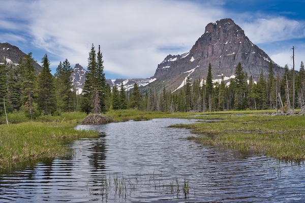
The panorama from Aster Park overlook is pretty sweet. To the east is Appistoki Peak. The reddish giant north across Two Medicine Lake is Rising Wolf Mountain. The pyramid-shaped summit peeking over the horizon to the northwest belongs to Flinsch Peak (see the featured image at the top of this post). It’s a textbook example of what happens to a mountain when glaciers grind away on opposing sides. Mountains like Flinsch are glacial horns.
In 1911, R. B. Marshall, the chief geographer for the United States Geological Survey, submitted the name Aster Park to the U.S. Board of Geographic Names.1 I’m guessing the purple flowers with yellow centers growing in the area caught his attention. But there is another purple flower with a yellow center growing in the area, often confused with aster. Its name is subalpine fleabane. That name followed by “park” just doesn’t quite have the same ring to it: good call, Mr. Marshall.
Hike Summary
| Total Distance (includes Paradise Point): 4.4 miles |
| Total Elevation Gain: 715 feet; Loss: 194 feet |
| Difficulty: 5.8, moderate* (Calculated using Petzoldt’s equation for energy-rated miles.) |
| Walking Time Estimate: 2 hours 7 minutes (The time was calculated using a walking speed of 2.5 miles-per-hour and Naismith’s Rule for elevation gain.) |
Notes
- “Aster Park.” United States Board of Geographic Names. Last modified May 25, 1911. https://geonames.usgs.gov/apex/f?p=138:3:::NO:3:P3_FID,P3_TITLE:779185,Aster%20Park.
- “Beargrass Blooms in Glacier National Park.” National Park Service, Glacier National Park. Last modified February 24, 2015. https://www.nps.gov/glac/learn/news/media13-41.htm.
- “Moose.” Wikipedia. Last modified January 13, 2021. https://en.wikipedia.org/wiki/Moose.
- “Moose – Alces americanus.” Montana Field Guide. Montana Natural Heritage Program and Montana Fish, Wildlife and Parks.. http://fieldguide.mt.gov/speciesDetail.aspx?elcode=AMALC03010.
- Robinson, Donald H. Through the Years: in Glacier National Park. 5th ed. West Glacier, MT: Glacier Natural History Association, Inc., 1973.
