Location
The trail to Scalplock Mountain and its fire lookout tower begins near the Walton Ranger station in the southern part of Glacier National Park. From West Glacier, drive 28 miles east on U.S. Highway 2. The entrance to the Walton station is about one mile east of Essex, Montana, just after the bridge over the Middle Fork of the Flathead River. From East Glacier, it’s 29 miles.
Immediately upon entering the complex, you’ll notice a dark-brown-stained cabin on the left. It’s the original structure built in 1932 for rangers assigned to this region of the park. To locate the trailhead, continue to the picnic area.
Why the name Scalplock?
Merriam-Webster defines scalp lock as a long tuft of hair on the crown of an otherwise shaved head, especially of a warrior from some American Indian tribes.
The Essex Fire in the summer of 1910 destroyed 113,926 acres of forest. This was the park’s first summer and also the summer of the infamous Big Burn. This wildfire destroyed millions of acres in northern Idaho and western Montana. According to Donald H. Robinson, in his book Through the Years, only a small clump of trees remained on top of the mountain after the fire. To someone, that cluster of timber reminded them of a scalp lock.2 Records from the United States Geological Service show the name became official in 1911.
Trip Planning
The footpath cuts through a lush forest, and vegetation crowds the trail along the first part of the route. If it has been wet, your legs and feet will end up in the same condition. So, it’s an excellent idea to pack rain gear.
It’s also a wise decision to carry bear spray where you can access the canister quickly. Know how to use it safely and effectively.
This ten-mile hike can take about five to six hours. Know that there is no water available on the climb nor at the top of Scalplock. Proper hydration is an important planning consideration. A general rule of thumb is to drink about 0.5 liters of water per hour.
The fuel of choice for the body when it’s working hard is quality carbohydrates. Graze as you walk to foster endurance. For this hike, using an average speed of 2.3 miles per hour, a person and their pack totaling 130 pounds will burn about 235 calories per hour, a 160 pound combo – 288 calories, 190 pounds – 343 calories, and at 220 pounds an estimated 397 calories per hour. (I calculated the number of calories using CalTopo to determine slopes and an online calculator that uses the military’s updated Load Carriage Decision Aid.)
On The Trail
The first section is part of the South Boundary Trail and is mellow for about the first 0.6 miles. At that point, a suspension bridge crosses Ole Creek. After the water crossing, there is an easy climb for another 0.6 miles to the junction with the Ole Creek Trail. Stay left.

The intersection with the Scalplock Lookout Trail is 0.1 miles farther. Take the path to the right. It’s a steady climb from that point to the top. Your legs will need to lift you 2,847 feet over the next 3.6 miles. Someone who considers themselves out of shape will probably not enjoy this climb.
Huckleberries and thimbleberries ripen mid-July in lower elevations to early September at higher locations. The Scalplock Trail has an abundance of both fruits. Predictably, bears come to feed on this vital food source. Be vigilant and make enough noise, so not to surprise one of these magnificent animals.
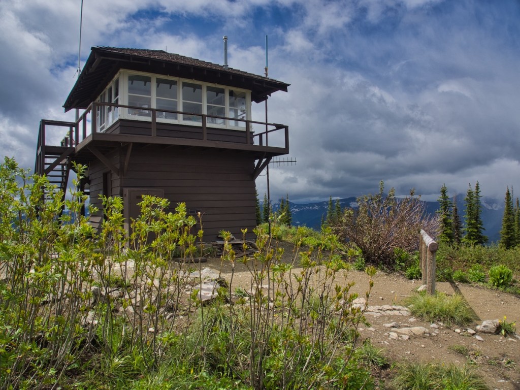
You’ll know the top is near when the forest canopy opens up on the ridge. Just before the last switchback, the lookout is visible through the trees. The Park Service built the structure in 1931 in response to fires originating along the railroad and U.S. Highway 2 corridor. Park Service personnel modernized the tower with solar panels. Probably the same table and chairs, though.

Doug Peacock, author, naturalist, and close friend of Edward Abbey (The Monkey Wrench Gang) manned the Scalplock and Huckleberry Lookouts during the years 1976 to 1984.¹ Peacock’s book, Grizzly Years: In Search of American Wilderness, is about his time alone in the Wyoming and Montana mountains, his life with grizzlies, and how they helped him heal from the atrocities he experienced in Viet Nam. I enjoyed it.
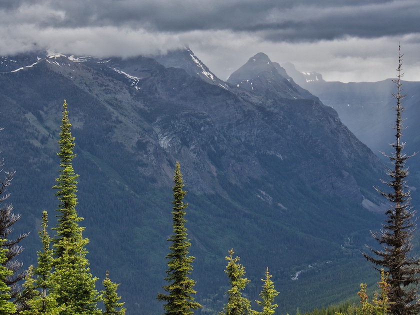
On a cloudless day, Mount Saint Nicholas, Salvage Mountain, and Church Butte rise to the north across the Park Creek Valley. Two Medicine Pass is at the far end of Park Creek. To the east on the far side of the Ole Creek Valley is Elk Mountain, which had its own fire lookout tower at one time. Looking to the immediate south and southeast are Running Rabbit Mountain, Snowslip Mountain, and Mount Shields. The Great Bear Wilderness stretches to the horizon on the south side of the U.S. Highway 2 (Roosevelt Highway).
Hike Summary
| Scalplock Mountain Summit: 6,919 feet |
| Total Distance: 10 miles |
| Total Elevation Gain: 3,347 feet; Loss: 190 feet |
| Walking Time Estimate: 5 to 6 hours |
| Difficulty Score: 16.4, strenuous* (Score calculated using the Petzoldt equation for energy-rated miles.) |
(For difficulty comparisons: St. Mary Falls 2.4, Bullhead Lake 7.8, Iceberg Lake 12.9, Dawson/Pitamakan Loop 24.7.)
Notes
- Butler, David R. Fire Lookouts of Glacier National Park. Charleston, SC: Arcadia Publishing, 2014.
- Robinson, Donald H. Through the Years in Glacier National Park. West Glacier, MT: Glacier Natural History Association, Inc., 1973.
