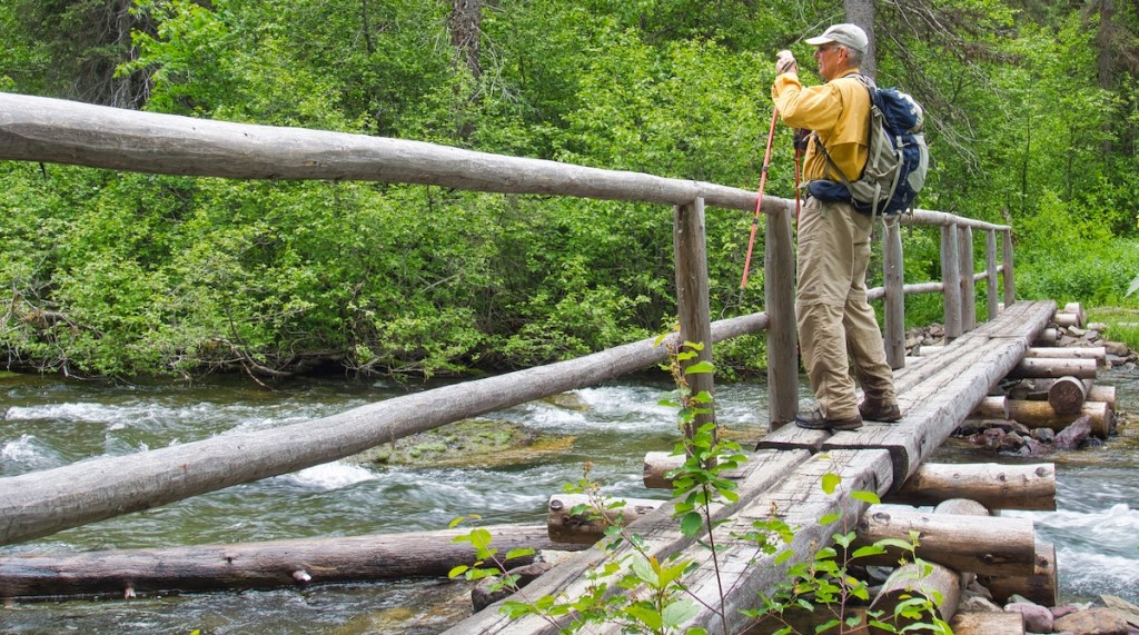
Located in the remote northwest region of Glacier National Park near Polebridge, Montana, this hike will take you through old growth forest to three crystal clear mountain lakes with views of magnificent peaks. I think the drive to get there is worth it.
The Inside North Fork Road (Glacier Route Seven) is closed between Camas and Logging Creeks. So, that leaves two options. From Columbia Falls, drive the North Fork Road for 35 miles (56.3 km) to Polebridge. This route is mostly gravel, and it can be a bone-jarring, dusty ride. The second choice is to drive through West Glacier into the park and out Camas Road. That leaves only about 14 miles (22.5 km) of mostly gravel, which is usually in a little better shape than the North Fork Road south of there.
As any local knows, you cannot visit this region of Glacier without first stopping at the Polebridge Mercantile and bakery located just outside the park. There will probably be someone around by 7 AM. Early is desirable because their fresh baked goods have a quasi-cult following. If you arrive around dinner time, check out the Northern Lights Saloon and Cafe next to the Merc. I doubt that they will disappoint you.
By the way, if the Mercantile seems old, it is. Bill Adair built the Merc in 1914. Local folks back then knew it merely as Adair’s. Bill and his wife ran the store and lived in their homestead cabin, which is now the Northern Lights Saloon and Cafe. These buildings are now part of the W.L. Adair General Mercantile Historic District which was placed on the National Register of Historic Places in 1983.¹

A few other things of which you should be aware. Polebridge and the surrounding area are off the grid. There is no cell service or Wi-Fi. However, there is a computer with the Internet in the store that the owner may let you use. And there is no public garbage service.
Trailhead
The hike begins near the Bowman Lake Campground and picnic area 6.3 miles (10.1 km) from Polebridge. Starting at the ‘Merc’, drive east toward the North Fork of the Flathead River, the western boundary of Glacier National Park. The entrance station is just past the east side of the bridge. The Red Bench Fire spared the ranger’s residence and check-station when it roared through during the summer of 1988. The other historic buildings were not so lucky.² ³
After passing through the check station, veer to the left and then take the first road to the right. The route leading to Bowman Lake is narrow and rough with blind curves and few pullouts. The Park Service prohibits vehicles or vehicle combinations over 21 feet (6.4 m).
Find the picnic area parking lot next to the campground. Signs will help you locate a path leading to the West Lakes Trail.

The Hike
The West Lakes Trail skirts the south end of Bowman Lake and crosses over Bowman Creek via a substantial footbridge. Within the first 0.5-miles (0.8 km) after the bridge, you will pass a ranger patrol cabin displaying moose antlers over the front porch. I’d like to know the history that this structure has witnessed since it’s construction in 1934. Not far from the cabin, a healthy-looking black bear crossed the trail in front of us.

After 0.6-miles (1.0 km) there is a junction with the Quartz Lake Trail. One can go right or left since it’s a loop hike. I prefer the clockwise direction or veering left. From the junction, it’s a climb of 1,200 feet (366 m) over four miles to the top of Cerulean Ridge. Passing over the top, old growth forest gives way to younger lodgepole pine trees. The 36,000-acre Red Bench Fire consumed the forest to the southwest along Quartz Ridge.³ This fire adapted species quickly reclaims the scorched land left in the wake of a fire.
Before the footpath descends far, openings in the trees provide views of all three bodies of water- Quartz Lake, Middle Quartz Lake, and Lower Quartz Lake.
I’m stingy with elevation. I hate to lose that which I’ve gained. But gaining the lake requires descending over 1,000 feet (305 m). At the shoreline of Quartz Lake, the trailhead is 6.1 miles (9.8 km) away with a little more than that remaining in the trip.
The backcountry campground next to the beach is a great place to rest and have a bite to eat. (There are three campsites. Only one is first come first serve.) We sat on the shore listening to the waves roll onto the gravel beach, with the smell of fir trees in the air, and the spectacular Vulture Peak rising into the clouds at the end of the 4-mile (6.4 km) long lake. Our only company was a curious whitetail buck, in velvet. Clouds moved down from the peaks, and a curtain of rain made its way across the water to our new position under large spruce trees. The sound of falling rain and its sweet smell was calming as long as I could shut out thoughts of the miles of wet brush we were about to walk through.

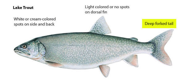
According to Carter Fredenberg, park fisheries biologist, non-native lake trout were first documented in Quartz Lake during 2005.⁴ This species outcompetes the native bull trout, a threatened species, found in the lake. Lake trout also disrupt native ecosystems when they show up.
Each year since 2009, Fredenberg and his team use a clever strategy to reduce the population of the outsider. They tag lake trout with radio transmitters. These fish lead the team to their fall spawning areas in Quartz Lake, where they deploy gill nets to remove the gathering lake trout. So far, it appears to be successful.⁴

Onward. The trail leaving the campground leads to a footbridge over Quartz Creek in 0.3-miles (0.5 km). At the same time, it changes direction from southeast to southwest. Middle Quartz Lake is small and only about 500 feet (152 m) from Quartz Lake. However, the views of this little gem don’t appear until after the bridge.
The 3.1-mile (5.0 km) walk from Quartz to Lower Quartz is under the canopy of old-growth forest. Glimpses of Quartz Ridge to the west occur every once in a while. You will walk parallel to the lake for a little over a mile before seeing the backcountry campground at the south end. (There are four campsites. Two are reservable. Unlike Quartz Lake, the Park Service allows stock at this site.) You’ll probably need your bug spray if you plan on staying. This site is not on my top ten list.
Upon leaving the campground, the path turns to the northwest. It crosses Quartz Creek via one of the longest footbridges that I have seen in the park. Over 2.6 miles (4.2 km), your legs will push you up almost 900 feet (274 m) in elevation to the crest of Quartz Ridge. The last leg of the loop drops nearly 1,100 feet (335 m) over 2 miles (3.2 km) before reaching the parking lot.

Mileage and Elevation Changes
| Section | Distance | Elevation Gain/Loss |
| TH to Quartz Lake | 6.1 mi/9.8 km | 1,550 ft (472 m)/1,180 ft (360 m) |
| Lower Quartz Lk | 3.1 mi/5 km | 0/225 ft (69 m) |
| back to TH | 3.5 mi/5.6 km | 900 ft (274 m)/1,100 ft (335 m) |
Notes
- “Adair, W.L. General Mercantile Historic District.” National Register of Historic Places. Last modified , 1985. Accessed July 15, 2019. https://npgallery.nps.gov/NRHP/GetAsset/NRHP/86000155_text
- “Polebridge Ranger Station Residence.” National Register of Historic Places. Last modified , 1984. Accessed July 15, 2019. https://npgallery.nps.gov/NRHP/GetAsset/ff5b2ecd-d11e-4f8a-86a5-1dee4d575199.
- “Wildfire History of Glacier National Park.” National Park Service. Accessed November 27, 2018. https://nps.maps.arcgis.com/apps/PublicInformation/index.html?appid=9636385ceaa14684b099ac4759792a7e.
- Wilson, Samuel. “Fish Work in Glacier Lake Shows Results.” Daily Inter Lake, March 18, 2015.
