The adventure to the Snyder Lakes and the headwaters of Snyder Creek begins in the shadows of a western redcedar and western hemlock forest. As the elevation increases, the forest transitions to spruce and subalpine fir, and finally to stunted and scattered subalpine fir and 10-foot (3-meter) high alder.
In August of 2017, lightning ignited the forest. The Sprague Fire burned 16,982 acres (6,872 hectares) and the iconic Sperry Chalet. You will see some evidence of the fire during this hike.
Grizzly bears are known to use the Snyder Creek drainage. Make plenty of noise. A surprised bear is usually not a nice bear. Practice safely unholstering and removing the safety clip from your canister of bear spray. And know and be able to judge the effective distance of the spray. Finally, know the discharge and aiming techniques.
The trail starts at 3,100 feet (945 meters) and ends 4.3 miles (6.9 kilometers) later at Lower Snyder Lake (5,247 feet/1,600 meters). The rest of the trip involves climbing up cliffs and bushwhacking to Upper Snyder Lake (5,575 feet/1,700 meters). The total round trip distance is 12.1 miles (19.5 kilometers).
The Sperry Trailhead is across the Going-to-the-Sun Road from Lake McDonald Lodge. This footpath leads to Sperry Chalet and beyond, but it also provides access to the Snyder Creek drainage. The route gradually gains elevation as it passes the Swan Mountain Outfitters Corral. Then it’s all business. If you’re out of shape, chances are good that this will not be enjoyable going up or coming down.
About 1.7 miles (2.7 kilometers) from the trailhead, you will pass the trail junction to Mount Brown Lookout. Walk another 0.1-miles (0.2-kilometers) and the Snyder Lake Trail will present itself. This route is not as steep as the Sperry Trail.
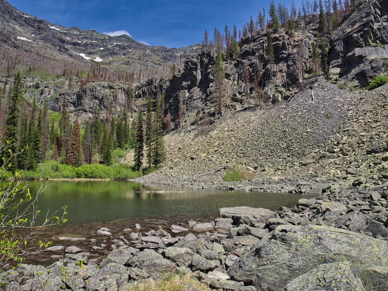
A little over 2 miles (3.2 kilometers) after entering the drainage, you will come to a bridge over Snyder Creek. There are three backcountry campsites along the trail and up from Snyder Lake not far from the bridge. Two of these are reservable. However, all will be closed July 1, 2019 for the rest of the season. Assuming a site is not occupied, these are convenient places to rest and eat. There are also a few places further along the trail where one can work their way down to the water’s edge.
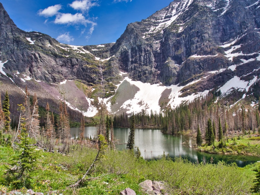
The trail diminishes and then disappears at the far end of the lake where a talus field begins. You can hear the water from Upper Snyder Lake cascading down a narrow canyon about 200 yards (183 meters) away. We chose the gorge as the place to negotiate the 300-foot (274-meter) cliffs separating the two lakes.
There were three of us. Tony took the lead. He is a climber of mountains and has years of experience. Counter to scientific thought, he has lungs that reach down to his knees and has the endurance of a mountain goat. We all need friends who challenge us. Tony challenges me physically and mentally. I have a thing about heights and exposure. He has been very patient while I have tried to work through this mental challenge. And, he is a motivator. For example, on a climb of a local mountain last summer, we arrived at the crux. There were two possible routes. In his quiet way, he told me that if I fell pursuing option number one, I would be seriously hurt but would probably survive. Falling from option two, I would most likely die.
I kept this in mind, as I was searching for a handhold on the crumbly rock with a glacier 200 feet (61 meters) below. He calmly said, “ take your time, no hurry.” I feel that I always grow a little when I go out with Tony.
We worked our way up through narrow openings in the 300-foot (91-meter) rock wall from short ledge to short ledge. Finally, we topped out and began our descent into the abyss of alder. Snyder Creek flows from the east and then makes an abrupt turn and flows from the north where it exits from Upper Snyder Lake. Getting to the lake involved negotiating bogs and the ever-present alder.

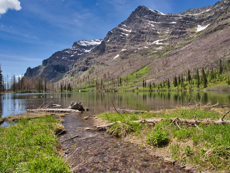
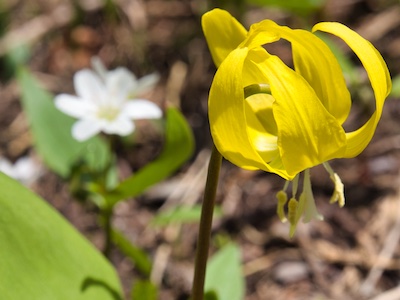
It was worth it. At the lake, hidden in a grand glacial cirque, Mount Brown, the Little Matterhorn, and Edwards Mountain stood like sentinels above us. At least seven waterfalls hundreds of feet tall thundered down the walls of the amphitheater. Spring was just beginning up there. White blossoms with light pink veins of spring beauty and bright yellow flowers of glacier lilies were showing off in small alpine meadows surrounding the lake.


Although George Snyder has the ridge above Lake McDonald, a creek, and two lakes named after him, I think this body of water is the best match.
Snyder came west from Wisconsin in 1894, with only 23 birthdays behind him. He was an independent-minded and a bit unorthodox young man. By the end of 1895, he had built a two-story hotel at the head of Lake McDonald on the site of the current Lake McDonald Lodge. But there was no road to the place, only a rudimentary horse trail. So, he purchased a 40-foot (12-meter) steamboat and had it shipped to Belton. He and other settlers built a crude narrow road from the Middle Fork of the Flathead River near Belton to Apgar. Hardy souls loaded the boat onto a stout wagon and transported it to the foot of the lake.² ³
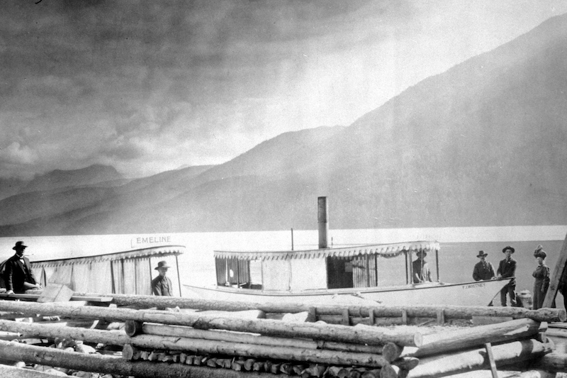
Snyder lost the hotel in 1906. The stories of drinking and gambling being involved may be factual or they might be a myth. At any rate, John Lewis became the new owner. Not defeated, George opened a hostel and pub near Glacier’s west entrance. Some locals, including Glacier National Park officials, viewed the drinking establishment as an offense against morality. Nevertheless, his businesses survived. Snyder was a thorn in the side of Glacier’s administration for years.¹
We returned by a route that took us to the far side of the lake. We could either climb higher and further to use the talus slopes on the southeast flank of Mount Brown and hopefully miss the cliffs. Or, go low and not as far. But that required more bushwhacking through alder.

There were distances that our feet never felt the ground only the flexible intertwined branches of the 10-foot (3-meter) tall shrubs from hell. Our lower legs looked like someone used a cat-o’-nine-tails on them. Negotiating the cliffs downward was not as bad as I thought it would be. Eventually, we intersected the Snyder Lake Trail about 0.1-miles (0.2 kilometers) downhill from the bridge over Snyder Creek.
We stopped long enough to clean out our boots, have a bite to eat, and filter some water for the return trip. After a 9.5 hour day, we were back at the trailhead.
Glacier National Park Guidebooks
Your Ultimate Guide to Going-to-the-Sun Road: Invest in your adventure and unlock the full potential of opportunities along this iconic road. For less than the price of a movie, a lifetime of memories.
Ready to explore? Tom Berquist, a local with nearly 1,000 miles of hiking the trails of Glacier under his belt, provides practical insights, detailed maps, wonderful photos, and valuable planning information. This guide is your trusted companion for an unforgettable East Side adventure.
Notes
- Fraley, John. Wild River Pioneers: adventures in the Middle Fork of the Flathead, Great Bear Wilderness, and Glacier National Park. Helena, MT: Farcountry Press, 2008.
- Guthrie, C.W. The First 100 Years. Helena, MT: Farcountry Press, 2008.
- Robinson, Donald H. Through the Years: in Glacier National Park. 5th ed. West Glacier, MT: Glacier Natural History Association, Inc., 1973.

2 responses to “Snyder Lake and Upper Snyder Lake”
Great post Tom. Makes me want to head up to Glacier.
LikeLiked by 1 person
Thanks! Glad you liked the post.
LikeLike