Trailhead
The beginning of the Iceberg Lake and Ptarmigan Trails can be found by following the Many Glacier Road to the Swiftcurrent Motor Inn and cabins. There is a road on the west end of the restaurant and camp store building, which leads to limited parking and the trailhead. If you’re not there early, it is probably better to leave your car in the main parking lot in front and walk back to the trailhead. It’s not far.
The restaurant, camp store, and gift shop, along with many of the small, simple cabins in the back, are part of the Swiftcurrent Auto Camp Historic District. In the early 1930s, the Great Northern Railway (GNR) subsidiary, Glacier Park Hotel Company, began building the facility in response to the new automobile tourist. This mobile visitor with limited funds started replacing the wealthy clientele courted by the GNR from 1910 to 1930.2
Notes for a Heavily Used Area
Iceberg Lake is a very popular hike. So, a few words about trail etiquette are in order. Generally, hikers going uphill have the right of way. That being said, if I’m alone going uphill and encounter a group coming down, it makes sense that I yield to the group. It’s a lot easier for me to move to the side than it is for the entire group to do the same.
We all hike at different speeds. Know that it’s considered rude to crowd folks in front of you. Use your favorite friendly greeting so that the people ahead know that you’re there. They should step aside and let you pass. If not, a polite request should do the trick.
There is a pit toilet about 2.6 miles from the trailhead just before the footpath crosses Ptarmigan Creek. If that doesn’t work out, the potty zone is at least 200 feet from the trail and any water. Using an average adult pace distance of 2.5 feet, then 80 paces should put one at about the correct distance from the path or surface water. One should dig a small cat hole to bury paper or solid waste.
I should also note that the Ptarmigan Trail and the Iceberg Lake Trail go through prime grizzly bear habitat. During July and August, berries are ripening. Both black and grizzly bears come to take advantage of this food source, and you will pass through their cafeteria. Be wise and let them know where you are by making noise. Keep your bear spray where you can access it quickly, and know how to use it. The park maintains a webpage with closures and postings for trails and backcountry campgrounds. It’s wise to check this information before heading out.
A Little Geology
The stories behind the chiseled, multilayered mountains make the trip even more spectacular. Trying to comprehend the time that has passed from the early stages of sediment eroding from a lifeless Earth surface to what we see today stretches the imagination. And, this only goes back one-third of the way to Earth’s beginning.1
During the Great Ice Age, that began around two-million years ago and ended around 12,000- years ago, enormous glaciers filled the valleys and ground away at the mountains like a gigantic rasp.3 Aretes, knife-edged ridges, resulted when ice rivers worked on two opposing sides of a mountain. Straight ahead to the northwest are the pinnacles of the glacial arete named the Ptarmigan Wall. When ice scoured rock on three sides, a horn remained. The glacial horn Mount Wilbur (9,231 feet) rises to the southwest.
The ice sculptor also exposed colorful layers of rock deposited over a billion years ago in the ancient Belt Sea. Then, seawater lapped a shoreline 50 miles west of Glacier National Park. Sediment deposited in shallow water reacted with oxygen resulting in reddish colors. That deposited into deeper water with minimal oxygen ended up being green. The beige and tan colors result from the remains of coral forming organisms.1
Red argillite of the Grinnell Formation makes up the base of Mount Wilbur. Just above the Grinnell Formation is the younger buff-colored limestone of the Siyeh Formation which caps both Mount Wilbur and Mount Henkel. If you look carefully at the east face of Mount Wilbur, about halfway between the base of the cliffs and the summit, there is a light gray band about 60 feet high. That is within the Siyeh Formation. This band extends through the Ptarmigan Wall above Iceberg Lake. That gray rock is rich with fossilized algae, which formed a reef hundreds of millions of years ago in the Belt Sea.1

The dark band toward the top of Mount Wilbur and the Ptarmigan Wall is a diorite sill. This band of igneous rock is approximately 100 feet thick and formed when magma was forced between the layers of sedimentary rock in the Siyeh Formation. The 1,000 to 2,000 degree Fahrenheit magma changed the resident limestone into marble. Notice the lighter-colored stone immediately above and below the dark gray sill. That’s the marble.1
The Hike
The first quarter of a mile is steep. But don’t let that dampen your enthusiasm. The slope of the path decreases to about 6% as it passes along the southwest slopes of Mount Henkel (8,770 feet). During May and June, the large, showy yellow flowers of arrowleaf balsamroot provide an excellent early season contrast to the slopes on which they grow. This open section of the trail offers quintessential Glacier National Park scenery.
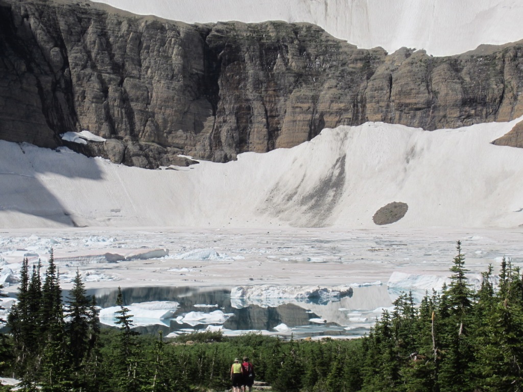
The footpath enters a forest about 1.5 miles from the trailhead. Farther down the trail, where the path uses a bridge to cross Ptarmigan Creek, is a perfect place to rest and grab a snack. Shortly after this is the junction to Iceberg Lake. Take the left fork. Going to the right will lead to Ptarmigan Tunnel. At three miles, the footpath emerges from the trees, and the glacial cirque holding Iceberg Lake comes into view.

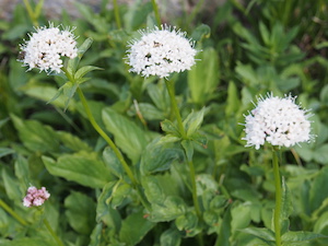
After you cross the footbridge over Iceberg Creek, you’ll enter a beautiful alpine meadow painted with a multitude of colors during July and August. Purple subalpine fleabane, white Sitka valerian, pink mountain heather, and light blue penstemon contribute to the show. It’s a sure bet that you’ll also see Columbian ground squirrels.

Iceberg Peak, to the west, and Mount Wilbur, to the southeast, rising more than 3,000 feet above the lake. Scan the rock faces for mountain goats. Golden eagles, with wingspans of six to eight feet, also hunt this area.


Expect a frozen lake, if you arrive in June. Icebergs should be plentiful in July and mostly gone by the middle of August. For me, no matter the month, sitting on the shoreline and taking it all in is rejuvenating.
“… we saw a mass of ice as large as a house part from the glacier, splash down into the deep lake …” James Willard Shultz, September 1, 19154

After the Hike
If you have never visited the historic Many Glacier Hotel, I recommend that this be the time to do so. The sprawling hotel, modeled after Swiss alpine chalets, was constructed by the Great Northern Railway during the years 1914 and 1915. Then, only the wealthy could afford to enjoy it. Now you can relax there with your hiking partners and enjoy refreshments while being wowed by the surrounding peaks with names like Mount Gould, Angel Wing, and the spectacular Grinnell Point that dominates the view across Swiftcurrent Lake.
Hike Summary
| Total Distance | 9.6 miles |
| Total Elevation Gain | 1,637 feet |
| Total Elevation Loss | 489 feet |
| Difficulty | 12.0, strenuous* (Score calculated using the Petzoldt equation for energy-rated miles.) |
| Total Walking Time | 4 hours 39 minutes (at 2.5 miles-per-hour and allowance for elevation gain) |
Before You Go . . .
If you’ve found this post useful, I invite you to check out my book Glacier National Park, Going-to-the-Sun Road: A Traveler’s Guide. Within this MultiTouch iBook are descriptions of hikes originating along the road corridor from West Glacier to Saint Mary. Interactive maps and photo galleries are included. You’ll also find points of interest highlighted, history, and other recreational opportunities. Thanks for visiting.
End Notes
- Dyson, James L. The Geologic Story of Glacier National Park, Bulletin No. 3. N.p.: Glacier Natural History Association, 1957. Accessed August 31, 2018. https://www.nps.gov/parkhistory/online_books/glac/3/index.htm
- National Register of Historic Places. “Swiftcurrent Auto Camp Historic District.” Accessed August 30, 2018. https://npgallery.nps.gov/NRHP/AssetDetail?assetID=9e575759-c2a0-4079-8d43-99638b12c14a.
- Ray, Louis L. The Great Ice Age. N.p.: U.S. Geological Survey, 1992. Accessed August 30, 2018. https://pubs.usgs.gov/gip/ice_age/ice_age.pdf.
- Schultz, James W. Blackfeet Tales of Glacier National Park. Boston: Houghton Mifflin Company, 1916. Accessed August 30, 2018. http://www.gutenberg.org/files/43399/43399-h/43399-h.htm.

Leave a comment