Tucked away in a glacial valley near the eastern border of Glacier National Park is a turquoise gem curiously called Cracker Lake. To be sure, the name has a story behind it. This and the spectacular scenery make for a unique adventure.

A Brief History
From the continental divide to the plains, Glacier National Park was once part of the Blackfeet Reservation created by the 1851 Fort Laramie Treaty. Ten-thousand Indians from several plains tribes gathered at the conference. Somehow word of the gathering arrived too late for the Blackfeet delegates to attend. The treaty set the Musselshell River, Missouri River, Yellowstone River, and the Rocky Mountain Range as the boundaries for the reservation.1
By executive order in 1873, President Ulysses Grant changed the boundaries, reducing the Blackfeet land. Grant received a lot of criticism over this action. Consequently, he restored their land in 1875. However, this was short-lived. By executive order in 1880, President Rutherford Hayes retook the property.1
President Benjamin Harrison signed the proclamation admitting Montana to the union on November 8, 1889. During the years 1890 to 1893, word spread like wildfire that there were abundant deposits of copper in the mountains. However, it was illegal to do any prospecting or mining on the land east of the continental divide because it was part of the Blackfeet Reservation.3
The Great Northern Railway arrived in East Glacier (Midvale) in 1891. The stage was set for miners and supplies to pour into the region.
Because of the pressure Congress received from the mining powers, President Cleveland appointed William C. Pollock, George Bird Grinnell, and Walter M. Clements to negotiate the purchase of that portion of the Blackfeet Reservation east of the continental divide to the prairies and from Canada south about 60 miles. They were successful. In 1896, the United States Congress ratified the purchase of the “Ceded Strip” for 1.5 million dollars.3
In 1897, L.S. Emmons and Hank Norris followed a mineral lead near the head of Canyon Creek. They stopped for lunch on the shore of Blue Lake. According to the famous story, they left their crackers and cheese at their lunch spot. After that, Emmons and Norris referred to the ore-bearing vein that they were following as “the lead where we left our crackers.” This eventually morphed into the cracker lead. Ultimately, Blue Lake inherited the name and became known as Cracker Lake.3
In 1898, the “Ceded Strip” opened for mining. The Cracker Mine at the head of Cracker Lake opened in the same year. Folks who hoped to profit from the mining operations built the town of Altyn near the mouth of Canyon Creek. This onetime robust little settlement got its name from Dave Altyn, one of the mine’s financial backers. At its peak, Altyn boasted a post office, saloons and dance halls, a store, a hotel, tent-houses, and cabins.2 The Bureau of Reclamation built Lake Sherburne Dam during the years 1914-1921. Now the reservoir hides this history.

Courtesy of Glacier National Park
The mining frenzy was short-lived. As mining experts had predicted, profitability was a pipe dream. Essentially, the bonanza ended by 1903. The Cracker Mine land exchanged hands several times over the years. Finally, the Glacier Natural History Association purchased the mine’s tax deed in September 1953 for $123.96. The Association transferred the land to the federal government in October of that year for the same amount of money.3
Trailhead
About four miles past the entrance station for Many Glacier, a road leads to the historic Many Glacier Hotel. Follow this road to the parking area east of the hotel. At the south end of the parking lot, the trail for Cracker Lake begins.
The Hike
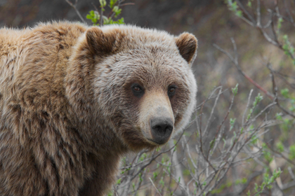
Know that this is prime grizzly bear habitat. In the past, park officials have also posted this trail for mountain lions. Make it a point to check the Glacier National Park Trail Status Reports before heading out. The vegetation can get thick, and there are plenty of blind curves. Make noise, hike in a group, carry bear spray where it is easily accessible. Be sure you have practiced taking the canister out of its holster and removing the safety clip.
Hikers and the Swan Mountain Outfitters’ horses share the first couple of miles of trail. It can be a muddy mess or a dusty, rutted trail with the recognizable fetor of equine deposits. After about 1.3 miles, the horses split off onto the Cracker Flats Horse Loop. This loop rejoins the trail at about 1.5 miles. The footpath improves substantially after this junction.
The trail crosses a footbridge over Allen Creek at 1.6 miles and then climbs a ridge between Allen Creek to the west and Canyon Creek to the east. From the ridge, the path descends into the Canyon Creek valley. Most of this section is in the trees. But there are glimpses of Allen Mountain to the southwest and Wynn Mountain to the east. At five miles from the trailhead, the headwall will appear to the south.

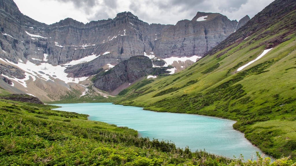
When the lake comes into view, one can’t help but pause. Cracker Lake’s milky-turquoise water, the ten-thousand-foot Mount Siyeh with its sheer north face rising over 4,000 feet from the head of Cracker Lake, and Allen Mountain to the west makes for a great photo op. Keep an eye out for mountain goats and hoary marmots.
Toward the lake’s head, the trail passes above a backcountry campground with only 3 campsites and no trees. Privacy, there is not—outstanding views without a doubt. The historic Cracker Mine site is about 0.3-miles beyond the spur trail to the campsites.

Cracker Mine
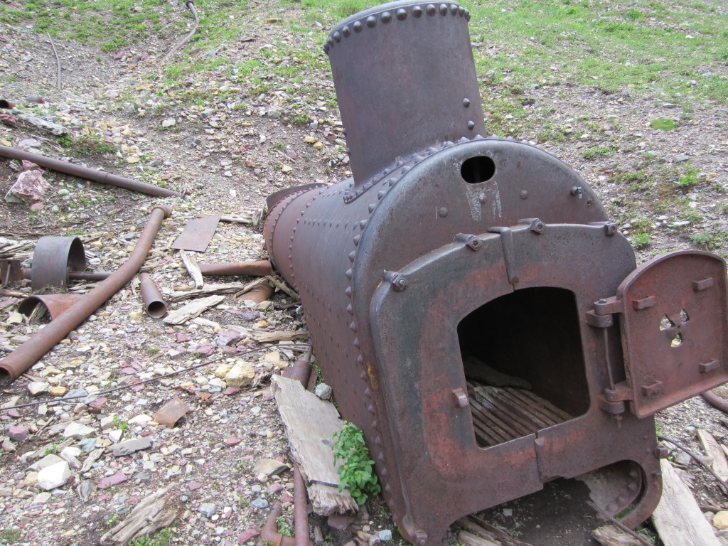
Park personnel collapsed the entrance to the 1,300-foot mine tunnel. Still, it’s obvious where the mine was located. The rusted remains of equipment lie scattered about near the lakeshore. Atlas Engine Works of Indianapolis, Indiana, made at least one piece. It boggles the mind how that enormous chunk of iron got from there to here.
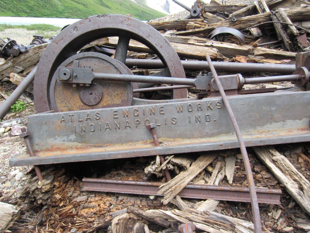
Charles Nielson of East Glacier got a contract to haul the mine’s 16,000-pound concentrator from Fort Browning to the mine site. Fort Browning was a trading post on the Milk River outside the town of Dodson in eastern Montana. That is a 250 to 300-mile trip to reach the mouth of Canyon Creek. Mr. Nielson used a large freight wagon and twelve stout mules on a journey with few roads. To haul the equipment up Canyon Creek, he used a block and tackle. For this monumental task, Nielson received $25 per day. The job took 29 days.3
The Return

Many Glacier Hotel is a superb place to finish the day. The Great Northern Railway completed the construction on July 4, 1915. Spectacular panoramas to the west include Swiftcurrent Lake, the iconic Grinnell Point, and Mount Wilbur. Recent rehabilitation work has ensured that we can enjoy this National Historic Landmark for years to come.
Good company, a cool beverage, stories and quintessential Glacier. Life is good!
Cracker Lake Hike Summary
| Total Distance | 13.0 miles |
| Total Elevation Gain | 1,873 feet |
| Total Elevation Loss | 835 feet |
| Difficulty | 16.7, strenuous* (Score calculated using the Petzoldt equation for energy-rated miles.) |
| Walking Time | 6 hours 8 minutes (at 2.5 miles-per-hour and allowance for elevation gain) |
(For comparison: Red Rock Lake: 4.3, easy; Grinnell Lake: 8.2, moderate)
Glacier National Park Guidebooks
Don’t just visit Glacier, experience it! This guide provides all the essential information you need for a seamless and enjoyable trip across the world-class Going-to-the-Sun Road. From lodging and dining to hiking trails, scenic viewpoints, and more, this guide has you covered. Order now and start planning your adventure.
A Local’s Hiking and Planning Guide for Eastern Glacier: Don’t let the park’s vastness overwhelm you. Our comprehensive ebook is your key to unlocking over 50 hikes through Glacier goodness. A one-time purchase, a lifetime of memories.
Notes
- “Blackfeet Reservation Timeline, Blackfeet Tribe.” Montana Office of Public Instruction. Last modified , 2017. Accessed August 14, 2020. https://opi.mt.gov/Portals/182/Page%20Files/Indian%20Education/Social%20Studies/K-12%20Resources/BlackfeetTimeline.pdf.
- Guthrie, C.W. The First 100 Years. Helena, MT: Farcountry Press, 2008.
- Robinson, Donald H. Through the Years: in Glacier National Park. 5th ed. West Glacier, MT: Glacier Natural History Association, Inc., 1973.
